McFadden-Brownsto complex, 0 to 6 percent slopes -- draft
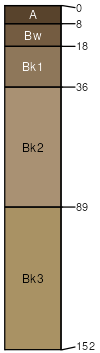
McFadden
(50%)
Shallow Sandy High Plains Southeast (SwSy)
Ustic Haplocalcids
Well drained
Hydric: No
PAWS: 12 cm
stream terraces / Footslope
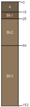
Brownsto
(30%)
Shallow Loamy Green River and Great Divide Basins (SwLy)
Ustic Haplocalcids
Well drained
Hydric: No
PAWS: 6 cm
stream terraces / Footslope
McFadden, wet
(5%)
Hydric:
PAWS: NA
Rawlins
(5%)
Hydric:
PAWS: NA
Rock River
(5%)
Hydric:
PAWS: NA
Bosler
(5%)
Hydric:
PAWS: NA
SSA
Scale
Published
Export
wy630
1:24,000
2025-09-04