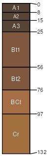
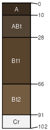
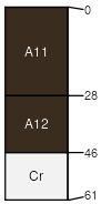
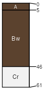
Rankor-Edmundston-Tweedy complex, 30 to 60 percent slopes

Rankor (35%)
Mesic Mountains <40 ppt
Pachic Argixerolls
Well drained
Hydric: No
PAWS: 16 cm
mountain slopes / Backslope
Edmundston (25%)
Granitic Hills and Mountains
Pachic Haploxerolls
Well drained
Hydric: No
PAWS: 12 cm
mountain slopes / Backslope
Tweedy (20%)
Granitic Hills and Mountains
Typic Argixerolls
Well drained
Hydric: No
PAWS: 16 cm
mountain slopes / Backslope
Sorrell (6%)
Typic Argixerolls

Hydric: No
PAWS: NA
mountain slopes
Locobill (4%)
Typic Haploxeralfs

Hydric: No
PAWS: NA
mountain slopes
Tollhouse (3%)
Entic Haploxerolls

Hydric: No
PAWS: NA
mountain slopes
Rock outcrop (3%)


Hydric: No
PAWS: NA
mountain slopes
Tunis (2%)
Typic Haploxerolls

Hydric: No
PAWS: NA
mountain slopes
Riverwash (1%)


Hydric: Yes
PAWS: NA
drainageways
channels
Unnamed (1%)


Hydric: Yes
PAWS: NA
flood plains
SSAScalePublishedExport
ca7601:24,00019812023-09-01