Smithdale-Lexington complex, 6 to 12 percent slopes, severely eroded
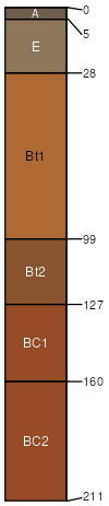
Smithdale
(67%)
Typic Hapludults
Well drained
Hydric: No
PAWS: 33 cm
hills / Summit
hills / Backslope
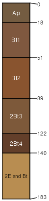
Lexington
(33%)
Northern Loess Interfluve
Ultic Hapludalfs
Well drained
Hydric: No
PAWS: 35 cm
interfluves / Backslope
SSA
Scale
Published
Export
ky610
1:12,000
1968
2025-09-08