| Luverne-Smithdale complex, 15 to 35 percent slopes | LsE | 49288 | 3116206 | 2svn7 | al001 | 1972 | 1:20000 |
Smithdale-Maubila-Boykin complex, 15 to 35 percent slopes | SmE | 23213 | 3116213 | 2z471 | al001 | 1972 | 1:20000 |
Boykin-Smithdale-Flomaton complex, gravelly, 10 to 35 percent slopes | BsE | 22920 | 3116397 | 2y6xj | al001 | 1972 | 1:20000 |
Smithdale sandy loam, 2 to 8 percent slopes | SmC | 13999 | 3116207 | 2svn6 | al001 | 1972 | 1:20000 |
Smithdale-Maubila-Boykin complex, 8 to 15 percent slopes | SmD | 8921 | 3116214 | 2z472 | al001 | 1972 | 1:20000 |
Luverne-Smithdale complex, 5 to 15 percent slopes | LsD | 815 | 3272046 | 2svn8 | al001 | 1972 | 1:20000 |
Maubila-Smithdale complex, 15 to 35 percent slopes | MsF | 48540 | 2232549 | 2s69w | al007 | 2007 | 1:24000 |
Luverne-Smithdale complex, 5 to 15 percent slopes | LsD | 46385 | 2232519 | 2svn8 | al007 | 2007 | 1:24000 |
Luverne-Smithdale complex, 15 to 35 percent slopes | LsF | 46125 | 2232525 | 2svn7 | al007 | 2007 | 1:24000 |
Smithdale sandy loam, 2 to 8 percent slopes | SmC | 29460 | 2233720 | 2svn6 | al007 | 2007 | 1:24000 |
Maubila-Smithdale-Boykin complex, 5 to 20 percent slopes | MsD | 15275 | 2232985 | 2dyls | al007 | 2007 | 1:24000 |
Smithdale sandy loam, 5 to 15 percent slopes | SmD | 14630 | 2238920 | 2f4s7 | al007 | 2007 | 1:24000 |
Wadley-Smithdale-Boykin complex, 5 to 20 percent slopes | WdE | 5645 | 2247144 | 2ffbj | al007 | 2007 | 1:24000 |
Maubila-Smithdale complex, 35 to 45 percent slopes | MsG | 5255 | 2232675 | 2dy8s | al007 | 2007 | 1:24000 |
Troup-Luverne-Smithdale complex, 15 to 35 percent slopes | TsF | 44940 | 328480 | 2s69m | al013 | 1996 | 1:20000 |
Smithdale sandy loam, 8 to 15 percent slopes | SmD | 5590 | 328477 | 2wwlw | al013 | 1996 | 1:20000 |
Boykin-Smithdale-Flomaton complex, gravelly, 10 to 35 percent slopes | BsE | 36104 | 3116197 | 2y6xj | al021 | 1967 | 1:20000 |
Maubila-Smithdale complex, 15 to 35 percent slopes | MsE | 122 | 3116198 | 2s69w | al021 | 1967 | 1:20000 |
Boykin-Luverne-Smithdale complex, 15 to 35 percent slopes | BnE2 | 82700 | 328565 | 2zx5c | al023 | 1998 | 1:24000 |
Smithdale sandy loam, 2 to 5 percent slopes | SmB | 44480 | 328594 | 2x5sj | al023 | 1998 | 1:24000 |
Smithdale loamy fine sand, 5 to 15 percent slopes | SmD | 27580 | 328595 | c0xv | al023 | 1998 | 1:24000 |
Wadley-Smithdale complex, 15 to 35 percent slopes | WsF | 65730 | 600045 | 2wtz1 | al025 | 2004 | 1:24000 |
Maubila-Wadley-Smithdale complex, 8 to 30 percent slopes | MbF | 49630 | 600074 | n4f7 | al025 | 2004 | 1:24000 |
Smithdale-Boykin complex, 2 to 5 percent slopes | SbB | 43800 | 600073 | 2s69n | al025 | 2004 | 1:24000 |
Smithdale-Boykin complex, 5 to 15 percent slopes | SbD | 43720 | 600072 | n4f5 | al025 | 2004 | 1:24000 |
Flomaton-Smithdale-Wadley complex, 10 to 25 percent slopes | FaE | 21580 | 600099 | n4g1 | al025 | 2004 | 1:24000 |
Smithdale-Saffell complex, 15 to 45 percent slopes | SsF | 10140 | 600098 | n4g0 | al025 | 2004 | 1:24000 |
Smithdale-Pikeville complex, 6 to 15 percent slopes | SpD | 14763 | 328709 | c11j | al033 | 1986 | 1:20000 |
Smithdale sandy loam, 15 to 35 percent slopes | SmE | 9602 | 328781 | c13v | al039 | 1985 | 1:20000 |
Troup-Luverne-Smithdale complex, 15 to 35 percent slopes | TsE | 1140 | 330512 | 2s69m | al041 | 2005 | 1:24000 |
Smithdale sandy loam, 8 to 15 percent slopes | SmD | 730 | 330511 | 2wwlw | al041 | 2005 | 1:24000 |
Smithdale-Saffell-Luverne complex, gravelly, 8 to 40 percent slopes | SnF | 21002 | 3272036 | 2zkvr | al051 | 1948 | 1:20000 |
Smithdale-Luverne association, 12 to 35 percent slopes | RtE | 97654 | 329501 | 2sh4l | al057 | 1963 | 1:15840 |
Smithdale fine sandy loam, 6 to 10 percent slopes, moderately eroded | RfC2 | 21173 | 329495 | 2vxx5 | al057 | 1963 | 1:15840 |
Smithdale-Luverne-Maubila complex, 15 to 35 percent slopes | CuE | 49483 | 329553 | 2sh52 | al059 | 1962 | 1:15840 |
Smithdale fine sandy loam, 6 to 10 percent slopes, moderately eroded | RuC2 | 7267 | 329592 | 2vxx5 | al059 | 1962 | 1:15840 |
Luverne-Smithdale complex, 15 to 35 percent slopes | LsF | 40516 | 329765 | 2svn7 | al065 | 2003 | 1:24000 |
Luverne-Smithdale complex, 5 to 15 percent slopes | LsD | 34614 | 329764 | 2svn8 | al065 | 2003 | 1:24000 |
Smithdale sandy loam, 2 to 8 percent slopes | ScC | 19424 | 329734 | 2svn6 | al065 | 2003 | 1:24000 |
Smithdale sandy loam, 5 to 15 percent slopes | ScD | 10850 | 329735 | c23m | al065 | 2003 | 1:24000 |
Maubila-Smithdale complex, 15 to 35 percent slopes | MsF | 9521 | 329768 | 2s69w | al065 | 2003 | 1:24000 |
Wadley-Smithdale-Boykin complex, 5 to 20 percent slopes | WbD | 6242 | 725102 | sbjd | al065 | 2003 | 1:24000 |
Maubila-Smithdale-Boykin complex, 5 to 20 percent slopes | MsD | 5513 | 329767 | c24n | al065 | 2003 | 1:24000 |
Luverne-Smithdale complex, 35 to 45 percent slopes | LsG | 2436 | 728353 | sfx8 | al065 | 2003 | 1:24000 |
Maubila-Smithdale complex, 35 to 45 percent slopes | MsG | 1162 | 725099 | sbj9 | al065 | 2003 | 1:24000 |
Smithdale-Luverne-Maubila complex, 15 to 35 percent slopes | SmE | 134600 | 2494834 | 2psg3 | al075 | 2010 | 1:24000 |
Luverne-Smithdale complex, 8 to 15 percent slopes | LsD | 51746 | 2494545 | 2sh54 | al075 | 2010 | 1:24000 |
Smithdale sandy loam, 2 to 8 percent slopes | SiC | 24730 | 2494836 | 2psg5 | al075 | 2010 | 1:24000 |
Smithdale fine sandy loam, 6 to 15 percent slopes | SiD | 11256 | 2494835 | 2sh4n | al075 | 2010 | 1:24000 |
Smithdale-Luverne-Maubila complex, 15 to 35 percent slopes | SsE | 2816 | 2494837 | 2sh52 | al075 | 2010 | 1:24000 |
Smithdale-Saffell complex, 15 to 35 percent slopes | SvE | 1250 | 2494838 | 2psg7 | al075 | 2010 | 1:24000 |
Smithdale fine sandy loam, 5 to 10 percent slopes | SmC | 6982 | 523058 | kk8v | al077 | 1973 | 1:20000 |
Brantley-Smithdale complex, 15 to 30 percent slopes | BsF | 20360 | 2514609 | 2qcv8 | al085 | 2011 | 1:24000 |
Luverne-Smithdale complex, 15 to 35 percent slopes | LvF | 9130 | 2514939 | 2svn7 | al085 | 2011 | 1:24000 |
Brantley-Smithdale complex, 30 to 60 percent slopes | BsG | 5396 | 2514610 | 2qcv9 | al085 | 2011 | 1:24000 |
Smithdale sandy loam, 8 to 15 percent slopes | SdD | 2832 | 2514628 | 2wwlw | al085 | 2011 | 1:24000 |
Smithdale sandy loam, 5 to 8 percent slopes | SdC | 1503 | 2514627 | 2qcvv | al085 | 2011 | 1:24000 |
Smithdale-Boykin-Luverne complex, 15 to 45 percent slopes | SmF | 50930 | 330596 | c30d | al091 | 1997 | 1:24000 |
Smithdale loamy sand, 5 to 8 percent slopes | SdC | 20270 | 330594 | c30b | al091 | 1997 | 1:24000 |
Smithdale loamy sand, 8 to 15 percent slopes | SdD | 17560 | 330595 | c30c | al091 | 1997 | 1:24000 |
Smithdale-Luverne association, 12 to 35 percent slopes | 34 | 69230 | 330637 | 2sh4l | al093 | 1976 | 1:20000 |
Smithdale fine sandy loam, 6 to 10 percent slopes | 32 | 40250 | 330635 | c31n | al093 | 1976 | 1:20000 |
Smithdale-Luverne complex, 15 to 35 percent slopes | 33 | 24250 | 330636 | 2sh55 | al093 | 1976 | 1:20000 |
Luverne-Smithdale association, hilly | 16 | 17600 | 330617 | c312 | al093 | 1976 | 1:20000 |
Smithdale fine sandy loam, 5 to 15 percent slopes | SmD | 1603 | 2995044 | 2t42r | al097 | 2018 | 1:24000 |
Smithdale sandy loam, 2 to 5 percent slopes | SmB | 233 | 2995043 | 2x5sj | al097 | 2018 | 1:24000 |
Smithdale sandy loam, 15 to 25 percent slopes, terrace escarpments | Ta | 1267 | 330990 | 30wkc | al101 | 1958 | 1:20000 |
Urban land-Anthoportic udorthents-Smithdale complex, 8 to 12 percent slopes | UAsD | 1264 | 330868 | 30wk7 | al101 | 1958 | 1:20000 |
Luverne-Smithdale complex, 15 to 35 percent slopes | LsE | 72 | 3116282 | 2svn7 | al101 | 1958 | 1:20000 |
Luverne-Smithdale complex, 15 to 35 percent slopes | LsE | 98200 | 331239 | 2svn7 | al105 | 1996 | 1:24000 |
Smithdale sandy loam, 2 to 8 percent slopes | ScB | 36020 | 331252 | 2svn6 | al105 | 1996 | 1:24000 |
Maubila-Smithdale complex, 15 to 35 percent slopes | MsE | 35890 | 331242 | 2s69w | al105 | 1996 | 1:24000 |
Smithdale sandy loam, 5 to 15 percent slopes | ScD | 20940 | 331253 | c3pl | al105 | 1996 | 1:24000 |
Luverne-Smithdale complex, 5 to 15 percent slopes | LsD | 12430 | 331238 | 2svn8 | al105 | 1996 | 1:24000 |
Smithdale-Luverne-Maubila complex, 15 to 35 percent slopes | SnF | 194590 | 331286 | 2sh52 | al107 | 1997 | 1:24000 |
Smithdale sandy loam, 5 to 8 percent slopes | SmC | 51890 | 331285 | c3qm | al107 | 1997 | 1:24000 |
Luverne-Smithdale complex, 8 to 15 percent slopes | LsD | 30500 | 331268 | 2sh54 | al107 | 1997 | 1:24000 |
Smithdale sandy loam, 5 to 8 percent slopes | SmC | 1540 | 331455 | c3x3 | al117 | 1982 | 1:24000 |
Smithdale sandy loam, 8 to 15 percent slopes | SmD | 1160 | 331456 | c3x4 | al117 | 1982 | 1:24000 |
Troup and Smithdale soils, 5 to 20 percent slopes | TSE | 45764 | 331495 | c3yd | al119 | 1986 | 1:24000 |
Smithdale loamy sand, 1 to 5 percent slopes | SmB | 11795 | 331490 | c3y7 | al119 | 1986 | 1:24000 |
Smithdale-Luverne association, 12 to 35 percent slopes | 39 | 118372 | 331533 | 2sh4l | al125 | 1980 | 1:20000 |
Smithdale-Luverne complex, 15 to 35 percent slopes | 36 | 46009 | 331530 | 2sh55 | al125 | 1980 | 1:20000 |
Smithdale-Ruston association, 5 to 35 percent slopes | 38 | 45240 | 331532 | 2sh4m | al125 | 1980 | 1:20000 |
Smithdale fine sandy loam, 6 to 15 percent slopes | 33 | 44274 | 331527 | 2sh4n | al125 | 1980 | 1:20000 |
Luverne-Smithdale complex, 4 to 10 percent slopes | 20 | 38934 | 331513 | c3yz | al125 | 1980 | 1:20000 |
Smithdale-Pikeville association, hilly | 40 | 37528 | 331535 | c3zp | al125 | 1980 | 1:20000 |
Smithdale-Flomaton complex, 15 to 35 percent slopes | 35 | 26702 | 331529 | c3zh | al125 | 1980 | 1:20000 |
Smithdale fine sandy loam, 15 to 35 percent slopes | 34 | 16612 | 331528 | 2rzvy | al125 | 1980 | 1:20000 |
Smithdale-Urban land complex, 6 to 15 percent slopes | 37 | 1610 | 331531 | c3zk | al125 | 1980 | 1:20000 |
Smithdale sandy loam, 8 to 25 percent slopes | SmE | 2221 | 331557 | c40d | al127 | 1986 | 1:24000 |
Smithdale fine sandy loam, 5 to 15 percent slopes | SmD | 9528 | 2642131 | 2t42r | al129 | 2013 | 1:24000 |
Boykin-Luverne-Smithdale complex, 15 to 35 percent slopes | BsF | 7962 | 2642063 | 2zx5c | al129 | 2013 | 1:24000 |
Smithdale sandy loam, 2 to 5 percent slopes | SmB | 5690 | 2642130 | 2x5sj | al129 | 2013 | 1:24000 |
Wadley-Boykin-Smithdale complex, 15 to 35 percent slopes | WbF | 4295 | 2642149 | 2rrx6 | al129 | 2013 | 1:24000 |
Wadley-Boykin-Smithdale complex, 5 to 15 percent slopes | WbD | 4043 | 2642148 | 2rrx5 | al129 | 2013 | 1:24000 |
Saffell-Smithdale-Luverne complex, 8 to 35 percent slopes | SaF | 36250 | 331672 | c443 | al131 | 1997 | 1:24000 |
Smithdale-Boykin complex, 2 to 5 percent slopes | SmB | 12500 | 331674 | 2s69n | al131 | 1997 | 1:24000 |
Savannah-Smithdale complex, 2 to 6 percent slopes | SaB | 4685 | 2524837 | 2qdnk | al133 | 2012 | 1:24000 |
Savannah-Smithdale complex, 6 to 10 percent slopes | SaC | 1777 | 2524838 | 2qysv | al133 | 2012 | 1:24000 |
Smithdale-Urban land complex, 2 to 6 percent slopes | SoB | 669 | 2435431 | 2mr89 | al133 | 2012 | 1:24000 |
Smithdale sandy loam, 8 to 25 percent slopes | SmD | 305 | 2515566 | 2qfdl | al133 | 2012 | 1:24000 |
Smithdale-Luverne complex, 15 to 35 percent slopes | SnE | 3 | 2524845 | 2qdmj | al133 | 2012 | 1:24000 |
Smithdale fine sandy loam, 8 to 12 percent slopes | 32 | 522 | 565083 | 2tztf | ar003 | 1977 | 1:20000 |
Smithdale fine sandy loam, 8 to 12 percent slopes | RuD | 516 | 565181 | 2v5xk | ar011 | 1959 | 1:20000 |
Smithdale fine sandy loam, 8 to 12 percent slopes | OfD | 152 | 565165 | 2tztf | ar011 | 1959 | 1:20000 |
Sacul-Smithdale association, rolling | 63 | 27274 | 3179399 | lynx | ar019 | 1983 | 1:20000 |
Smithdale fine sandy loam, 3 to 8 percent slopes | 76 | 1906 | 3179413 | 2tztg | ar019 | 1983 | 1:20000 |
Smithdale-Bowie-Sacul association, undulating | 77 | 36 | 3179414 | lypd | ar019 | 1983 | 1:20000 |
Smithdale fine sandy loam, 3 to 8 percent slopes | 27 | 22361 | 565363 | 2tztg | ar027 | 1983 | 1:20000 |
Smithdale fine sandy loam, 3 to 8 percent slopes | CaC | 4704 | 565448 | 2tztg | ar043 | 1972 | 1:24000 |
Smithdale fine sandy loam, 8 to 12 percent slopes | CaD | 1679 | 565449 | 2tztf | ar043 | 1972 | 1:24000 |
Smithdale fine sandy loam, 3 to 8 percent slopes | 45 | 18630 | 565672 | 2tztg | ar057 | 1976 | 1:20000 |
Sacul-Smithdale association, rolling | 63 | 15704 | 3179289 | lynx | ar059 | 1983 | 1:20000 |
Smithdale-Bowie-Sacul association, undulating | 77 | 7028 | 3179304 | lypd | ar059 | 1983 | 1:20000 |
Smithdale fine sandy loam, 3 to 8 percent slopes | 76 | 1288 | 3179303 | 2tztg | ar059 | 1983 | 1:20000 |
Smithdale fine sandy loam, 3 to 8 percent slopes | StC | 9921 | 721497 | 2tztg | ar099 | 2000 | 1:24000 |
Smithdale fine sandy loam, 15 to 35 percent slopes | StE | 7735 | 721499 | s6s5 | ar099 | 2000 | 1:24000 |
Smithdale fine sandy loam, 8 to 15 percent slopes | StD | 2752 | 721498 | 2ynxz | ar099 | 2000 | 1:24000 |
Smithdale fine sandy loam, 8 to 12 percent slopes | CaD | 1915 | 566053 | 2tztf | ar103 | 1969 | 1:20000 |
Smithdale-Urban land complex, 3 to 8 percent slopes | SuC | 8569 | 566208 | m05s | ar119 | 1972 | 1:20000 |
Smithdale fine sandy loam, 3 to 8 percent slopes | StC | 7115 | 566206 | 2tztg | ar119 | 1972 | 1:20000 |
Smithdale fine sandy loam, 8 to 12 percent slopes | StD | 1819 | 566207 | 2tztf | ar119 | 1972 | 1:20000 |
Smithdale loamy sand, 3 to 8 percent slopes | 25 | 22853 | 566233 | m06l | ar125 | 1976 | 1:20000 |
Smithdale-Urban land complex, 3 to 8 percent slopes | 26 | 3382 | 566234 | m06m | ar125 | 1976 | 1:20000 |
Smithdale loamy sand, 8 to 12 percent slopes | 27 | 3176 | 566235 | m06n | ar125 | 1976 | 1:20000 |
Smithdale and Darco loamy sands, 12 to 30 percent slopes | 28 | 2123 | 566236 | m06p | ar125 | 1976 | 1:20000 |
Smithdale fine sandy loam, 3 to 8 percent slopes | 33C | 10217 | 1707534 | 1v9tr | ar133 | 1996 | 1:24000 |
Warnock-Smithdale complex, 1 to 7 percent slopes | WsC | 44422 | 579209 | mfq5 | ar139 | 1992 | 1:24000 |
Smithdale fine sandy loam, 3 to 8 percent slopes | SmC | 14850 | 579194 | 2tztg | ar139 | 1992 | 1:24000 |
Smithdale fine sandy loam, 8 to 15 percent slopes | SmD | 6758 | 579195 | 2ynxz | ar139 | 1992 | 1:24000 |
Smithdale fine sandy loam, 15 to 30 percent slopes | SmE | 4693 | 579196 | mfpr | ar139 | 1992 | 1:24000 |
Sacul-Smithdale association, gently rolling | 20 | 21167 | 564675 | lylb | ar620 | 1977 | 1:20000 |
Smithdale fine sandy loam, 3 to 8 percent slopes | 25 | 20748 | 564680 | 2tztg | ar620 | 1977 | 1:20000 |
Smithdale-Sacul association, rolling | 29 | 16199 | 564684 | lylm | ar620 | 1977 | 1:20000 |
Smithdale association, rolling | 28 | 8037 | 564683 | lyll | ar620 | 1977 | 1:20000 |
Smithdale fine sandy loam, 3 to 8 percent slopes | 27 | 7817 | 564682 | 2v5xh | ar620 | 1977 | 1:20000 |
Smithdale fine sandy loam, 8 to 12 percent slopes | 26 | 5021 | 564681 | 2tztf | ar620 | 1977 | 1:20000 |
Smithdale fine sandy loam, 3 to 8 percent slopes | 47 | 16640 | 564870 | 2tztg | ar660 | 1975 | 1:20000 |
Smithdale fine sandy loam, 8 to 12 percent slopes | 48 | 8762 | 564871 | 2tztf | ar660 | 1975 | 1:20000 |
Smithdale fine sandy loam, 5 to 8 percent slopes | 74 | 27312 | 564952 | lyw8 | ar670 | 1981 | 1:20000 |
Smithdale sandy loam, 5 to 8 percent slopes | 34 | 878 | 564318 | ly6t | ar680 | 1980 | 1:20000 |
Brandon-Saffell-Smithdale complex, 20 to 35 percent slopes, eroded | BnE2 | 14822 | 570619 | 2wn5f | ky083 | 1995 | 1:12000 |
Brandon-Smithdale complex, 12 to 20 percent slopes, severely eroded | BsD3 | 14131 | 570620 | m4s3 | ky083 | 1995 | 1:12000 |
Brandon-Purchase-Smithdale complex, 12 to 20 percent slopes, eroded | BdD2 | 9939 | 570618 | m4s1 | ky083 | 1995 | 1:12000 |
Smithdale sandy loam, 20 to 45 percent slopes, eroded | SmE2 | 9749 | 570650 | m4t2 | ky083 | 1995 | 1:12000 |
Providence-Smithdale complex, 12 to 20 percent slopes, severely eroded | PmD3 | 4636 | 570641 | m4ss | ky083 | 1995 | 1:12000 |
Gullied land-Smithdale-Feliciana complex, 15 to 55 percent slopes | GuE | 1907 | 570633 | m4sj | ky083 | 1995 | 1:12000 |
Smithdale-Saffell complex, 35 to 55 percent slopes, eroded | SsE2 | 433 | 570651 | m4t3 | ky083 | 1995 | 1:12000 |
Brandon-Saffell-Smithdale complex, 20 to 35 percent slopes, eroded | BnE2 | 3714 | 1592732 | 2wn5f | ky602 | 1972 | 1:12000 |
Brandon-Smithdale complex, 12 to 20 percent slopes, severely eroded | BsD3 | 1154 | 1597368 | 1qm60 | ky602 | 1972 | 1:12000 |
Brandon-Saffell-Smithdale complex, 20 to 35 percent slopes, eroded | BsE2 | 12052 | 2232584 | 2wn5f | ky610 | 1968 | 1:12000 |
Saffell-Smithdale-Brandon complex, 20 to 60 percent slopes | SsF | 10214 | 2232592 | 2dy63 | ky610 | 1968 | 1:12000 |
Saffell-Smithdale-Brandon complex, 20 to 60 percent slopes, severely eroded | SsF3 | 7061 | 2623441 | 2qykg | ky610 | 1968 | 1:12000 |
Smithdale-Lexington complex, 12 to 25 percent slopes, severely eroded | SlD3 | 3111 | 2232605 | 2dy6j | ky610 | 1968 | 1:12000 |
Smithdale-Lexington complex, 12 to 25 percent, eroded | SlD2 | 1610 | 2232604 | 2dy6h | ky610 | 1968 | 1:12000 |
Smithdale sandy loam, 20 to 45 percent slopes, eroded | SmE2 | 1257 | 2232601 | 2dy6d | ky610 | 1968 | 1:12000 |
Smithdale, Toinette and Luverne soils, 25 to 60 percent slopes | STF | 1250 | 2232599 | 2vxy0 | ky610 | 1968 | 1:12000 |
Smithdale loam, 12 to 20 percent slopes, eroded | SdD2 | 514 | 2232600 | 2dy6c | ky610 | 1968 | 1:12000 |
Saffell-Brandon-Smithdale complex, 6 to 12 percent slopes, severely eroded | SbC3 | 69 | 2232591 | 2dy62 | ky610 | 1968 | 1:12000 |
Providence-Smithdale complex, 12 to 20 percent slopes, severely eroded | PmD3 | 65 | 2232589 | 2dy60 | ky610 | 1968 | 1:12000 |
Smithdale-Lexington complex, 6 to 12 percent slopes, severely eroded | SlC3 | 16 | 2232603 | 2dy6g | ky610 | 1968 | 1:12000 |
Smithdale fine sandy loam, 8 to 20 percent slopes | SVF | 217 | 1724604 | 1vwld | la013 | 1992 | 1:24000 |
Larue-Smithdale association, moderately steep | LA | 1610 | 1725654 | 1vxp8 | la021 | 1985 | 1:24000 |
Smithdale-Oula-Providence association, 5 to 40 percent slopes | SP | 16914 | 1722421 | 1vt9z | la025 | 1983 | 1:24000 |
Smithdale-Briley(lucy)-Providence association, 5 to 25 percent slopes | SR | 13794 | 1722422 | 1vtb0 | la025 | 1983 | 1:24000 |
Sweatman-Smithdale association, 5 to 40 percent slopes | SW | 10401 | 1722425 | 1vtb3 | la025 | 1983 | 1:24000 |
Oula-Providence-Smithdale association, 5 to 40 percent slopes | OA | 8541 | 1722407 | 1vt9j | la025 | 1983 | 1:24000 |
Memphis-Smithdale association, 5 to 40 percent slopes | MS | 8463 | 1722403 | 1vt9d | la025 | 1983 | 1:24000 |
Alaga-Smithdale-Briley(lucy) association, 5 to 40 percent slopes | AA | 3249 | 1722375 | 1vt8h | la025 | 1983 | 1:24000 |
Smithdale fine sandy loam, 5 to 12 percent slopes | Sm | 4679 | 569335 | 2ynxy | la027 | 1986 | 1:20000 |
Smithdale sandy loam, 8 to 30 percent slopes | SM | 16309 | 1605282 | 1qwf9 | la037 | 1992 | 1:24000 |
Smithdale fine sandy loam, 5 to 12 percent slopes | Sm | 67392 | 1527486 | 2ynxy | la043 | 1982 | 1:24000 |
Ruston-Smithdale association, moderately rolling | RS | 12458 | 1527481 | 1n8gl | la043 | 1982 | 1:24000 |
Smithdale fine sandy loam, 12 to 30 percent slopes | Sm | 34382 | 1600193 | 1qq44 | la059 | 1986 | 1:24000 |
Smithdale-Lucy-Providence association, 5 to 25 percent slopes | SR | 1072 | 1600203 | 1qq4g | la059 | 1986 | 1:24000 |
Smithdale fine sandy loam, 8 to 20 percent slopes | Sm | 11711 | 1903130 | 21wc9 | la069 | 1983 | 1:24000 |
Smithdale fine sandy loam, 8 to 12 percent slopes | RsE | 379 | 1725308 | 2tztf | la073 | 1969 | 1:24000 |
Smithdale fine sandy loam, 8 to 12 percent slopes | SmE | 23439 | 569988 | 2tztf | la079 | 1973 | 1:24000 |
Smithdale fine sandy loam, 12 to 20 percent slopes | SmF | 18417 | 569989 | m43r | la079 | 1973 | 1:24000 |
Ruston-Smithdale association, 3 to 12 percent slopes | RS | 48024 | 1721646 | 2w8yd | la091 | 1991 | 1:24000 |
Smithdale fine sandy loam, 12 to 20 percent slopes | SM | 2178 | 1721648 | 2vy0n | la091 | 1991 | 1:24000 |
Smithdale fine sandy loam, 8 to 12 percent slopes | Sm | 1904 | 327019 | 2sywb | la103 | 1985 | 1:24000 |
Ruston-Smithdale association, 3 to 12 percent slopes | RS | 63997 | 1536521 | 2w8yd | la105 | 1985 | 1:24000 |
Smithdale fine sandy loam, 12 to 20 percent slopes | Sm | 1663 | 1536524 | 2vy0n | la105 | 1985 | 1:24000 |
Smithdale fine sandy loam, 8 to 15 percent slopes | SM | 22382 | 1725366 | 2ynxz | la111 | 1992 | 1:24000 |
Smithdale fine sandy loam, 8 to 12 percent slopes | Sm | 36938 | 1724153 | 2sywb | la117 | 1989 | 1:24000 |
Smithdale fine sandy loam, 12 to 20 percent slopes | Sn | 7886 | 1724154 | 2vy0n | la117 | 1989 | 1:24000 |
Ruston-Smithdale association, 3 to 12 percent slopes | Ru | 592 | 1898811 | 2w8yd | la117 | 1989 | 1:24000 |
Smithdale fine sandy loam, 5 to 12 percent slopes | SM | 14248 | 570365 | 2ynxy | la119 | 1989 | 1:24000 |
Smithdale sandy loam, 8 to 30 percent slopes | SM | 11994 | 1725616 | 1vxn1 | la125 | 2002 | 1:24000 |
Smithdale fine sandy loam, 5 to 20 percent slopes | SM | 8785 | 1725982 | 1vy0v | la127 | 1991 | 1:24000 |
Smithdale-Ruston association, 5 to 35 percent slopes | CrE | 35906 | 331733 | 2sh4m | ms003 | 1967 | 1:20000 |
Smithdale sandy loam, 12 to 35 percent slopes | SmE | 42734 | 567460 | m1h5 | ms005 | 1971 | 1:20000 |
Smithdale sandy loam, 8 to 12 percent slopes | SmD | 33232 | 567458 | m1h3 | ms005 | 1971 | 1:20000 |
Susquehanna-Smithdale association, hilly | SSE | 18243 | 567455 | m1h0 | ms005 | 1971 | 1:20000 |
Smithdale sandy loam, 8 to 12 percent slopes, severely eroded | SmD3 | 7456 | 567459 | m1h4 | ms005 | 1971 | 1:20000 |
Smithdale sandy loam, 12 to 35 percent slopes, severely eroded | SmE3 | 2179 | 567461 | m1h6 | ms005 | 1971 | 1:20000 |
Smithdale fine sandy loam, 15 to 40 percent slopes | 32F | 75894 | 331770 | 2shry | ms007 | 1997 | 1:24000 |
Smithdale-Sweatman complex, 15 to 35 percent slopes, eroded | 60F2 | 68637 | 331793 | 2tjkf | ms007 | 1997 | 1:24000 |
Smithdale fine sandy loam, 8 to 15 percent slopes | 32D | 24357 | 331769 | 2shrx | ms007 | 1997 | 1:24000 |
Smithdale-Sweatman complex, 8 to 15 percent slopes, eroded | 60D2 | 24222 | 331792 | c47z | ms007 | 1997 | 1:24000 |
Smithdale-Udorthents complex, gullied | 70 | 2509 | 331794 | c481 | ms007 | 1997 | 1:24000 |
Smithdale and Toinette soils, 20 to 45 percent slopes | STF | 75624 | 331817 | 2vxy1 | ms009 | 1972 | 1:20000 |
Smithdale-Sweatman-Providence association, 12 to 35 percent slopes | SSF | 47194 | 331818 | 2vxx0 | ms009 | 1972 | 1:20000 |
Smithdale-Lexington complex, 12 to 17 percent slopes, eroded | SdF2 | 8989 | 331819 | c48v | ms009 | 1972 | 1:20000 |
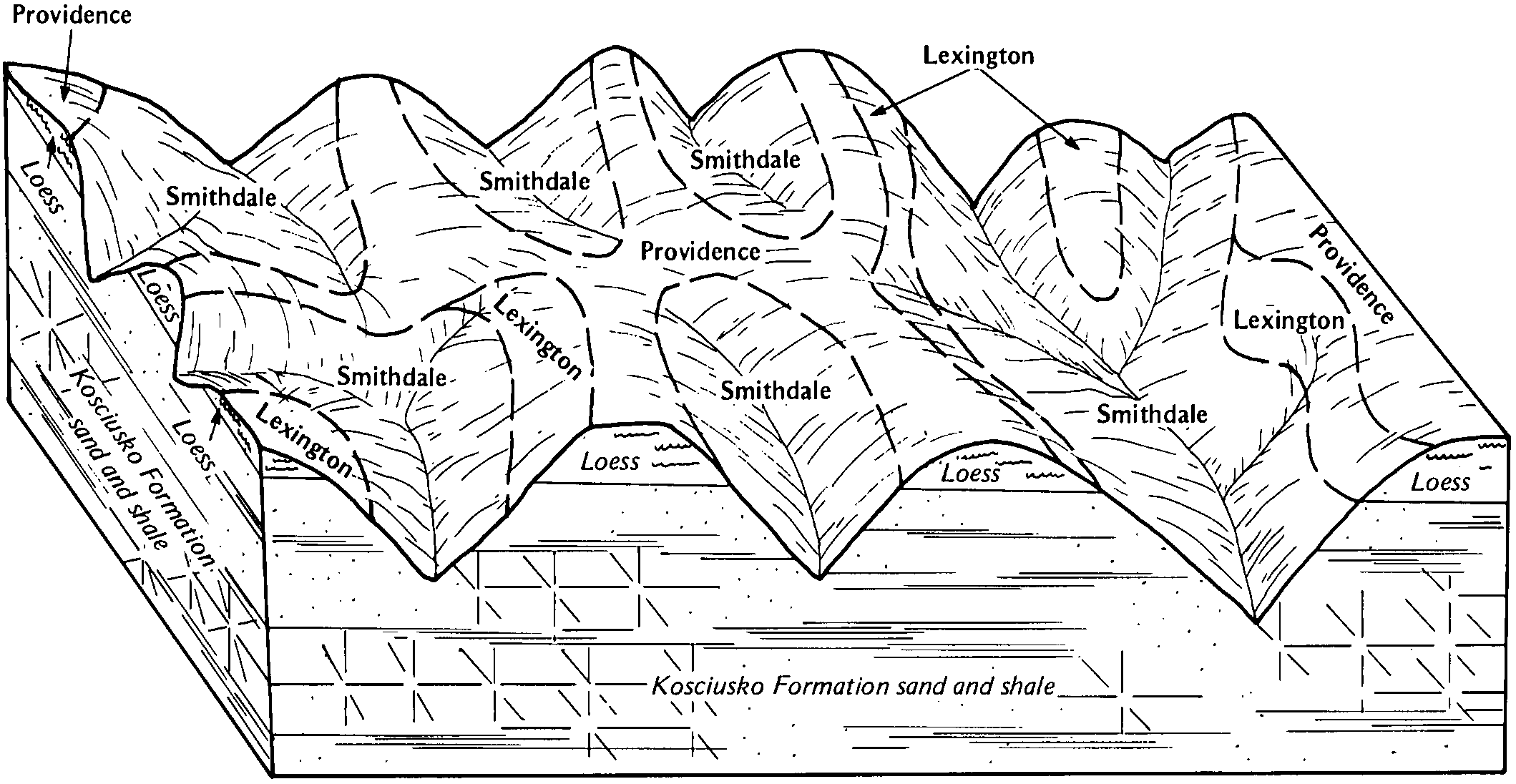
Smithdale-Providence-Lexington association, hilly | 9F | 65839 | 567569 | m1lp | ms015 | 1985 | 1:20000 |
Smithdale sandy loam, 12 to 30 percent slopes, eroded | 10E2 | 9757 | 567523 | m1k6 | ms015 | 1985 | 1:20000 |
Gullied land-Smithdale complex | 48 | 5064 | 567548 | m1l0 | ms015 | 1985 | 1:20000 |
Smithdale fine sandy loam, 12 to 40 percent slopes | CaF | 21422 | 331879 | 30wbd | ms017 | 1969 | 1:20000 |
Smithdale-Sweatman association, hilly | SS | 34590 | 331951 | c4f3 | ms019 | 1982 | 1:20000 |
Smithdale-Ruston association, 5 to 40 percent slopes | SR | 18156 | 331950 | 2sh50 | ms019 | 1982 | 1:20000 |
Smithdale-Maben association, hilly | SN | 17486 | 331949 | c4f1 | ms019 | 1982 | 1:20000 |
Smithdale fine sandy loam, 8 to 15 percent slopes | SmE | 7215 | 331955 | 2shrx | ms019 | 1982 | 1:20000 |
Smithdale fine sandy loam, 15 to 35 percent slopes | SmF | 4179 | 331956 | 2rzvy | ms019 | 1982 | 1:20000 |
Smithdale fine sandy loam, 5 to 8 percent slopes | SmC | 26754 | 2810630 | 2tjkd | ms023 | 1963 | 1:15840 |
Smithdale fine sandy loam, 17 to 35 percent slopes | SmF | 26466 | 2695044 | 2rzvm | ms023 | 1963 | 1:15840 |
Smithdale fine sandy loam, 12 to 17 percent slopes | SmE | 23671 | 2695043 | 2rzvk | ms023 | 1963 | 1:15840 |
Wadley-Toinette-Smithdale association, 12 to 40 percent slopes | EsF | 19856 | 3121741 | 2z24j | ms023 | 1963 | 1:15840 |
Smithdale fine sandy loam, 8 to 12 percent slopes | SmD | 15494 | 2695042 | 2rzvj | ms023 | 1963 | 1:15840 |
Orangeburg fine sandy loam, 12 to 17 percent slopes (smithdale) | OrE | 1476 | 332025 | c4hh | ms023 | 1963 | 1:15840 |
Orangeburg fine sandy loam, 17 to 35 percent slopes (smithdale) | OrF | 883 | 332026 | c4hj | ms023 | 1963 | 1:15840 |
Orangeburg fine sandy loam, 8 to 12 percent slopes (smithdale) | OrD | 736 | 332023 | c4hf | ms023 | 1963 | 1:15840 |
Cahaba fine sandy loam, 5 to 12 percent slopes, eroded (smithdale) | CaD2 | 422 | 331984 | c4g5 | ms023 | 1963 | 1:15840 |
Orangeburg fine sandy loam, 8 to 12 percent slopes, severely eroded (smithdale) | OrD3 | 173 | 332024 | c4hg | ms023 | 1963 | 1:15840 |
Smithdale-Ruston association, 5 to 40 percent slopes | SRE | 13477 | 332103 | 2sh50 | ms025 | 1974 | 1:20000 |
Sweatman-Smithdale association, hilly | SXE | 2925 | 332104 | 2shs7 | ms025 | 1974 | 1:20000 |
Lorman-Smithdale association, hilly | LS | 48949 | 567685 | m1qf | ms029 | 1981 | 1:20000 |
Smithdale sandy loam, 17 to 40 percent slopes | SmF | 36784 | 567708 | m1r5 | ms029 | 1981 | 1:20000 |
Smithdale sandy loam, 12 to 17 percent slopes | SmE | 24320 | 567707 | m1r4 | ms029 | 1981 | 1:20000 |
Smithdale-Lexington association hilly | ST | 20976 | 567703 | m1r0 | ms029 | 1981 | 1:20000 |
Smithdale sandy loam, 8 to 12 percent slopes | SmD | 13463 | 567706 | m1r3 | ms029 | 1981 | 1:20000 |
Saffell-Smithdale association, hilly | SF | 5300 | 567702 | m1qz | ms029 | 1981 | 1:20000 |
Smithdale sandy loam, 17 to 40 percent slopes, severely eroded | SmF3 | 875 | 567709 | m1r6 | ms029 | 1981 | 1:20000 |
Ruston fine sandy loam, 12 to 17 percent slopes (smithdale) | RsE | 20668 | 332180 | c4nh | ms031 | 1962 | 1:15840 |
Wadley-Toinette-Smithdale association, 12 to 40 percent slopes | EsF | 11190 | 3121740 | 2z24j | ms031 | 1962 | 1:15840 |
Ruston fine sandy loam, 12 to 17 percent slopes, eroded (smithdale) | RsE2 | 6202 | 332181 | c4nj | ms031 | 1962 | 1:15840 |
Ruston fine sandy loam, 17 to 40 percent slopes (smithdale) | RsF | 5270 | 332183 | c4nl | ms031 | 1962 | 1:15840 |
Ruston fine sandy loam, 8 to 12 percent slopes, eroded (smithdale) | RsD2 | 5229 | 332178 | c4nf | ms031 | 1962 | 1:15840 |
Ruston fine sandy loam, 8 to 12 percent slopes (smithdale) | RsD | 4499 | 332177 | c4nd | ms031 | 1962 | 1:15840 |
Ruston, Ora, and Cuthbert soils, 5 to 12 percent slopes (smithdale, ora and sweatman) | RuC | 4276 | 332186 | c4np | ms031 | 1962 | 1:15840 |
Ruston fine sandy loam, 12 to 17 percent slopes, severely eroded (smithdale) | RsE3 | 4123 | 332182 | c4nk | ms031 | 1962 | 1:15840 |
Ruston fine sandy loam, 8 to 12 percent slopes, severely eroded (smithdale) | RsD3 | 1748 | 332179 | c4ng | ms031 | 1962 | 1:15840 |
Ruston fine sandy loam, 17 to 40 percent slopes, eroded (smithdale) | RsF2 | 450 | 332184 | c4nm | ms031 | 1962 | 1:15840 |
Ruston fine sandy loam, 17 to 40 percent slopes, severely eroded (smithdale) | RsF3 | 237 | 332185 | c4nn | ms031 | 1962 | 1:15840 |
Smithdale sandy loam, 15 to 40 percent slopes | 38F1 | 100266 | 567811 | m1vh | ms037 | 1992 | 1:20000 |
Smithdale-Lexington association, 5 to 40 percent slopes | 69F | 14966 | 567819 | m1vr | ms037 | 1992 | 1:20000 |
Smithdale sandy loam, 8 to 15 percent slopes | 38D1 | 8262 | 567810 | m1vg | ms037 | 1992 | 1:20000 |
Smithdale-Lexington-Memphis association, 5 to 40 percent slopes | 70F | 7075 | 567820 | m1vs | ms037 | 1992 | 1:20000 |
Lorman-Smithdale association, 15 to 35 percent slopes | 78F | 1619 | 567824 | m1vx | ms037 | 1992 | 1:20000 |