Fairburn-Baux-Rock outcrop complex, 30 to 60 percent slopes
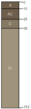
Fairburn
(31%)
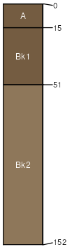
Shallow Loamy (SwLy) 15-19 Northern Plains Precipitation Zone
Aridic Ustorthents
Well drained
Hydric: No
PAWS: 6 cm
hills / Summit
hills / Shoulder
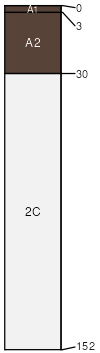
Baux
(29%)
Very Shallow (VS) 15-19 Northern Plains Precipitation Zone
Aridic Haplustolls
Excessively drained
Hydric: No
PAWS: 4 cm
hills / Shoulder
hills / Backslope
hills / Footslope
Rock outcrop
(25%)
Hydric: No
PAWS: NA
free faces / Shoulder
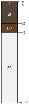
Bauxson
(4%)
Shallow Loamy (SwLy) 15-19 Northern Plains Precipitation Zone
Aridic Argiustolls
Well drained
Hydric: No
PAWS: 7 cm
hills / Summit
hills / Shoulder
hills / Backslope
Ironbutte
(4%)
Shallow Loamy (SwLy) 15-19 Northern Plains Precipitation Zone
Aridic Ustorthents
Well drained
Hydric: No
PAWS: 5 cm
hills / Summit
hills / Shoulder
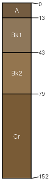
Ucross
(4%)
Loamy (Ly) 15-19 Northern Plains Precipitation Zone
Aridic Ustorthents
Well drained
Hydric: No
PAWS: 14 cm
hills / Shoulder
hills / Backslope
hills / Footslope
Iwait
(3%)
Loamy (Ly) 15-19 Northern Plains Precipitation Zone
Aridic Ustorthents
Well drained
Hydric: No
PAWS: 40 cm
hills / Backslope
hills / Footslope
SSA
Scale
Published
Export
wy719
1:24,000
2013
2025-09-04