Westmoreland-Dekalb complex, 25 to 40 percent slopes
gray mottles in the lower part of the subsoil
(%)
Hydric:
PAWS: NA
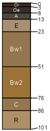
channery loam surface layer
(%)
Hydric:
PAWS: NA
many sandstone fragments in subsoil; bedrock at 40-60 inches
(%)
Hydric:
PAWS: NA
silt loam surface layer
(%)
Hydric:
PAWS: NA
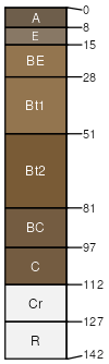
Westmoreland
(55%)
Side Slope
Ultic Hapludalfs
Well drained
Hydric: No
PAWS: 16 cm
hills / Backslope
Dekalb
(30%)
Side Slope
Typic Dystrochrepts
Well drained
Hydric: No
PAWS: 8 cm
hills / Backslope
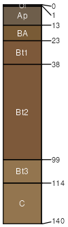
Rigley
(15%)
Hydric:
PAWS: NA
hills
SSA
Scale
Published
Export
oh013
1:16,000
1978
2025-08-27