Smithpond-Montwel-Badland complex, 4 to 15 percent slopes
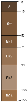
Smithpond
(50%)
Semidesert Sandy Loam (Fourwing Saltbush)
Ustic Haplocalcids
Well drained
Hydric: No
PAWS: 23 cm
fan remnants / Backslope
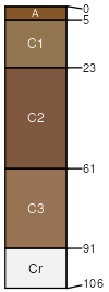
Montwel
(30%)
Desert Loam (Shadscale)
Typic Torriorthents
Well drained
Hydric: No
PAWS: 13 cm
hills / Toeslope
Badland
(15%)
Hydric: No
PAWS: NA
Mespun
(2%)
Semidesert Sand (Fourwing Saltbush)
Ustic Torripsamments
Excessively drained
Hydric: No
PAWS: NA
fan remnants
Muff
(2%)
Desert Alkali Bench (Castlevalley saltbush)
Typic Natrargids
Well drained
Hydric: No
PAWS: NA
hills / Toeslope
Rock outcrop
(1%)
Hydric: No
PAWS: NA
cliffs
erosion remnants
escarpments
ledges
SSA
Scale
Published
Export
ut013
1:24,000
2025-08-27