Euell-Hungryhill-Bullrey complex, 4 to 15 percent slopes
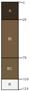
Euell
(40%)
Upland Alpine Group
Vitrandic Argicryolls
Well drained
Hydric: No
PAWS: 13 cm
ridges
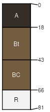
Hungryhill
(30%)
Upland Alpine Group
Ustic Argicryolls
Well drained
Hydric: No
PAWS: 8 cm
ridges
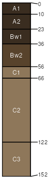
Bullrey
(25%)
Upland Alpine Group
Pachic Haplocryolls
Well drained
Hydric: No
PAWS: 14 cm
saddles
ridges
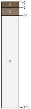
Larkspur
(5%)
Shallow Sagebrush Shrubland Group
Lithic Cryorthents
Well drained
Hydric: No
PAWS: 2 cm
ridges
SSA
Scale
Published
Export
mt635
1:24,000
2006
2025-08-31