|
|
|
Rock outcrop (15%)
Hydric: Unranked
PAWS: NA |

|
|
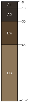
Burtoner (2%)
Typic Argiustolls
Well drained
Hydric: No
PAWS: 9 cm |

|
|
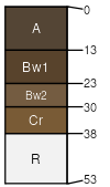
Baxton (2%)
Typic Haplustolls
Well drained
Hydric: No
PAWS: 8 cm |
hillsides mountainsides ridges
|
|
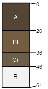
Connieo (2%)
Lithic Argiustolls
Well drained
Hydric: No
PAWS: 5 cm |
escarpments hillsides ridges
|
|
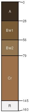
Breeton (2%)
Upland Shrubland Group
Pachic Haplustolls
Well drained
Hydric: No
PAWS: 17 cm |
alluvial fans hillsides terraces
|
|
Elmark (2%)
Typic Haplustalfs
Well drained
Hydric: No
PAWS: 9 cm |

hillsides ridges mountainsides escarpments
|
|