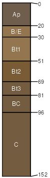
Cardington silt loam, 12 to 18 percent slopes, eroded
Cardington
(85%)
Till Ridge
Aquic Hapludalfs
Moderately well drained
Hydric: No
PAWS: 21 cm
ground moraines / Summit
ground moraines / Shoulder
ground moraines / Backslope
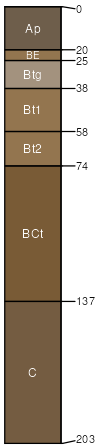
Bennington
(8%)
Hydric:
PAWS: NA
flats
ground moraines
severely eroded areas with a silty clay loam surface layer
(7%)
Hydric:
PAWS: NA
SSA
Scale
Published
Export
oh175
1:16,000
1980
2025-09-09