Badland-Bonhigh complex, 2 to 20 percent slopes
Badland
(30%)
Hydric: No
PAWS: NA
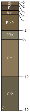
Bonhigh
(25%)
Clayey Foothills and Basins West (Cy)
Aridic Haplustalfs
Well drained
Hydric: No
PAWS: 8 cm
hillslopes / Backslope
Volborg taxadjunct
(10%)
Shale Foothills and Basins West (Sh)
Aridic Ustorthents
Well drained
Hydric: No
PAWS: 6 cm
hillslopes / Backslope
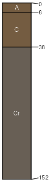
Cacklin
(10%)
Sandy Pinedale Plateau (Sy PP)
Aridic Haplustalfs
Well drained
Hydric: No
PAWS: 14 cm
hillslopes / Backslope
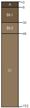
Cackmod
(10%)
Sandy Pinedale Plateau (Sy PP)
Aridic Haplustalfs
Well drained
Hydric: No
PAWS: 8 cm
hillslopes / Backslope
Lauzer family
(10%)
Saline Upland Foothills and Basins West (SU)
Aridic Natrustalfs
Well drained
Hydric: No
PAWS: 10 cm
hillslopes / Backslope
Polaris
(5%)
Very Shallow Foothills and Basins West (VS)
Aridic Calciustepts
Well drained
Hydric: No
PAWS: 5 cm
hillslopes / Footslope
SSA
Scale
Published
Export
wy635
1:24,000
2025-09-04