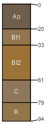
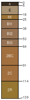
Gilpin-Wellston silt loams, 10 to 25 percent slopes
Gilpin
(51%)
Moderately Deep Siltstone-Shale Uplands
Typic Hapludults
Well drained
Hydric: No
PAWS: 13 cm
hills / Shoulder
hills / Backslope
Wellston
(49%)
Deep Well Drained Siltstone-Shale Uplands
Typic Hapludults
Well drained
Hydric: No
PAWS: 19 cm
hills / Shoulder
hills / Backslope
SSA
Scale
Published
Export
in013
1:16,000
1985
2025-09-04