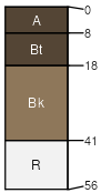
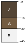
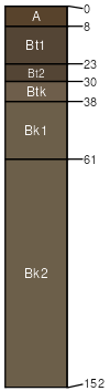
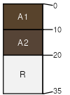
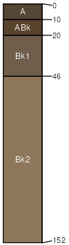
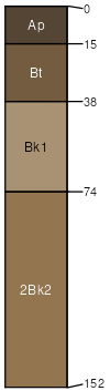
Gnojek,very stony-Tolbert,very stony-Shawmut,very stony complex, 35 to 60 percent slopes

Gnojek (35%)
Upland Sagebrush Shrubland Group
Lithic Argiustolls
Well drained
Hydric: No
PAWS: 3 cm
mountain slopes / Shoulder
mountain slopes / Backslope
Tolbert (30%)
Upland Sagebrush Shrubland Group
Lithic Argiustolls
Well drained
Hydric: No
PAWS: 3 cm
mountain slopes / Summit
mountain slopes / Backslope
Shawmut (15%)
Upland Sagebrush Shrubland Group
Typic Argiustolls
Well drained
Hydric: No
PAWS: 12 cm
mountain slopes / Backslope
mountain slopes / Footslope
Rock outcrop (10%)


Hydric:
PAWS: NA
Vershal (5%)
Lithic Haplustolls
Well drained
Hydric: No
PAWS: 1 cm
mountain slopes / Shoulder
mountain slopes / Backslope
Winspect (3%)
Typic Calciustolls
Well drained
Hydric: No
PAWS: 16 cm
mountain slopes / Shoulder
mountain slopes / Backslope
Meagher (2%)
Typic Argiustolls
Well drained
Hydric: No
PAWS: 18 cm
swales / Footslope
mountain slopes
SSAScalePublishedExport
mt6691:24,0002023-08-29