| Winspect-Ustic Calcicryolls, families, complex, 0 to 35 percent slopes | 43B7EF | 944 | 3458648 | 31wmc | id720 | | 1:24000 |
Winspect-Winspect, cool-Rock outcrop complex, 25 to 60 percent slopes | 702F | 1172 | 344252 | ck6x | mt051 | 1992 | 1:24000 |
Wimper-Winspect complex, 4 to 8 percent slopes | 129C | 181 | 154565 | 55tz | mt616 | 2003 | 1:24000 |
Wimper-Winspect complex, 15 to 35 percent slopes | 129E | 142 | 154566 | 55v0 | mt616 | 2003 | 1:24000 |
Winspect gravelly loam, 8 to 30 percent slopes | 339E | 134 | 154719 | 55zy | mt616 | 2003 | 1:24000 |
Winspect gravelly loam, 35 to 60 percent slopes, moderately impacted | 1039F | 56 | 155231 | 56jg | mt616 | 2003 | 1:24000 |
Winspect cobbly loam, 35 to 60 percent slopes | 339F | 17 | 154720 | 55zz | mt616 | 2003 | 1:24000 |
Winspect gravelly loam, 15 to 35 percent slopes, moderately impacted | 1039E | 4 | 155230 | 56jf | mt616 | 2003 | 1:24000 |
Winspect gravelly loam, 8 to 15 percent slopes, moderately impacted | 1039D | 3 | 155229 | 56jd | mt616 | 2003 | 1:24000 |
Winspect gravelly loam, 15 to 35 percent slopes | 39E | 4274 | 144382 | 4v7h | mt621 | 1997 | 1:24000 |
Winspect gravelly loam, 35 to 60 percent slopes | 39F | 2198 | 144383 | 4v7j | mt621 | 1997 | 1:24000 |
Winspect gravelly loam, 8 to 15 percent slopes | 39D | 1759 | 144381 | 4v7g | mt621 | 1997 | 1:24000 |
Wimper-Winspect complex, 15 to 35 percent slopes | 129E | 1387 | 144191 | 4v1b | mt621 | 1997 | 1:24000 |
Winspect-Lap gravelly loams, 15 to 35 percent slopes | 139E | 962 | 144203 | 4v1q | mt621 | 1997 | 1:24000 |
Winspect-Lap gravelly loams, 35 to 60 percent slopes | 139F | 744 | 144204 | 4v1r | mt621 | 1997 | 1:24000 |
Winspect gravelly loam, 4 to 8 percent slopes | 39C | 730 | 144380 | 4v7f | mt621 | 1997 | 1:24000 |
Wimper-Winspect cobbly loams, 15 to 35 percent slopes | 229E | 376 | 144278 | 4v44 | mt621 | 1997 | 1:24000 |
Wimper-Winspect complex, 8 to 15 percent slopes | 129D | 195 | 144190 | 4v19 | mt621 | 1997 | 1:24000 |
Winspect-Rock outcrop complex, 35 to 60 percent slopes | 439F | 107 | 144404 | 4v86 | mt621 | 1997 | 1:24000 |
Wimper-Winspect complex, 35 to 60 percent slopes | 129F | 58 | 144192 | 4v1c | mt621 | 1997 | 1:24000 |
Winspect-Rock outcrop complex, 15 to 35 percent slopes | 439E | 13 | 144403 | 4v85 | mt621 | 1997 | 1:24000 |
Winspect cobbly loam, 4 to 8 percent slopes | 239C | 11 | 144282 | 4v48 | mt621 | 1997 | 1:24000 |
Winspect-Rock outcrop complex, 60 to 80 percent slopes | 439G | 10 | 144405 | 4v87 | mt621 | 1997 | 1:24000 |
Fairfield-Beanlake-Winspect stony loams, 2 to 25 percent slopes | 643D | 27574 | 147877 | 4yw7 | mt630 | 1991 | 1:24000 |
Beanlake-Winspect stony loams, dry, 2 to 25 percent slopes | 343D | 22495 | 147793 | 4ysj | mt630 | 1991 | 1:24000 |
Beanlake-Winspect stony loams, 4 to 25 percent slopes | 543D | 21085 | 147848 | 4yv9 | mt630 | 1991 | 1:24000 |
Winspect-Cabba-Wayden complex, 8 to 35 percent slopes | 443E | 9728 | 147820 | 4ytd | mt630 | 1991 | 1:24000 |
Regent-Fairfield-Winspect stony loams, 8 to 35 percent slopes | 743D | 3068 | 147901 | 4yx0 | mt630 | 1991 | 1:24000 |
Winspect, dry-Cabbart complex, 15 to 45 percent slopes | 833E | 2604 | 147917 | 4yxj | mt630 | 1991 | 1:24000 |
Winspect gravelly loam, 15 to 35 percent slopes | 39E | 375 | 1702930 | 1v517 | mt635 | 2006 | 1:24000 |
Winspect gravelly loam, 35 to 60 percent slopes | 39F | 188 | 1702931 | 1v518 | mt635 | 2006 | 1:24000 |
Winspect gravelly loam, 8 to 15 percent slopes | 39D | 31 | 1702929 | 1v516 | mt635 | 2006 | 1:24000 |
Winspect, very bouldery-Blaincreek, very stony-Tolbert, very stony complex, 8 to 35 percent slopes | 50E | 1722 | 639209 | pg4n | mt637 | 2014 | 1:24000 |
Winspect-Work-Bowery, 8 to 35 percent slopes, extremely bouldery | 419E | 1352 | 149983 | 5125 | mt639 | 2000 | 1:24000 |
Winspect cobbly loam, 4 to 15 percent slopes | 303D | 927 | 149870 | 50yj | mt639 | 2000 | 1:24000 |
Winspect-Ticell complex, 15 to 35 percent slopes | 310E | 446 | 149877 | 50yr | mt639 | 2000 | 1:24000 |
Lap-Winspect complex, 35 to 70 percent slopes | 412F | 399 | 149975 | 511x | mt639 | 2000 | 1:24000 |
Winspect very cobbly loam, 15 to 35 percent slopes | 303E | 230 | 149871 | 50yk | mt639 | 2000 | 1:24000 |
Lap-Winspect-Rock outcrop complex, 8 to 35 percent slopes | 412E | 107 | 149974 | 511w | mt639 | 2000 | 1:24000 |
Shawmut-Winspect-Water complex, 8 to 25 percent slopes | 651E | 3318 | 145848 | 4wrs | mt644 | 1995 | 1:24000 |
Winspect gravelly loam, 15 to 35 percent slopes | 39E | 1821 | 145723 | 4wmr | mt644 | 1995 | 1:24000 |
Shawmut-Winspect-Water complex, 2 to 8 percent slopes | 651C | 1537 | 145847 | 4wrr | mt644 | 1995 | 1:24000 |
Winspect gravelly loam, 8 to 15 percent slopes | 39D | 1394 | 145722 | 4wmq | mt644 | 1995 | 1:24000 |
Shawmut-Winspect-Water complex, 25 to 50 percent slopes | 651F | 672 | 145849 | 4wrt | mt644 | 1995 | 1:24000 |
Winspect gravelly loam, 35 to 60 percent slopes | 39F | 637 | 145724 | 4wms | mt644 | 1995 | 1:24000 |
Winspect gravelly loam, 4 to 8 percent slopes | 39C | 129 | 145721 | 4wmp | mt644 | 1995 | 1:24000 |
Beanlake-Winspect cobbly loams, 2 to 15 percent slopes | 327C | 24769 | 348571 | cpq7 | mt657 | 1990 | 1:24000 |
Winspect-Beanlake cobbly loams, 15 to 35 percent slopes | 327E | 17536 | 348572 | cpq8 | mt657 | 1990 | 1:24000 |
Beanlake-Manhattan-Winspect complex, 2 to 15 percent slopes | 727C | 5251 | 348793 | cpyd | mt657 | 1990 | 1:24000 |
Beanlake-Saypo-Winspect complex, 0 to 8 percent slopes | 427C | 5038 | 348644 | cpsl | mt657 | 1990 | 1:24000 |
Winspect, extremely bouldery-Meagher, extremely bouldery-Sawicki, extremely bouldery-Bacbuster, stony complex, cool, 15 to 45 percent slopes | 5620E | 3971 | 699329 | rgq0 | mt669 | | 1:24000 |
Winspect, Stony - Castner, Very Stony Complex, 15 to 60 percent slopes,Warm | 8611F | 2717 | 699359 | rgqz | mt669 | | 1:24000 |
Winspect-Wilspring complex, 8 to 30 percent slopes | 725E | 266 | 362067 | d4rl | mt670 | 2007 | 1:24000 |
Winspect gravelly loam, 8 to 30 percent slopes | 724E | 197 | 362068 | d4rm | mt670 | 2007 | 1:24000 |
Osote-Winspect complex, 2 to 20 percent slopes | DLC | 7536 | 1479887 | 1lny9 | ut013 | | 1:24000 |
Flynncove-Winspect-Altonah complex, 30 to 70 percent slopes, rubbly | 18_BIA | 6353 | 1707982 | 1vb96 | ut013 | | 1:24000 |
Maryjane-like-Winspect-Sixbeacon complex, 15 to 75 percent slopes | 4503 | 1886 | 3209075 | 2zdr8 | wy629 | | 1:24000 |
Winspect-Lolo-Rock outcrop complex, 40 to 70 percent slopes | 4607 | 307 | 3170955 | 2z1zk | wy629 | | 1:24000 |
Campspass-like-Winspect-Mcmannamy-like complex, 15 to 35 percent slopes | 9446 | 159 | 3250460 | 2zv6j | wy629 | | 1:24000 |
Winspect-Corpening-Wimper complex, 4 to 40 percent slopes | 4410 | 108 | 3170975 | 2z206 | wy629 | | 1:24000 |
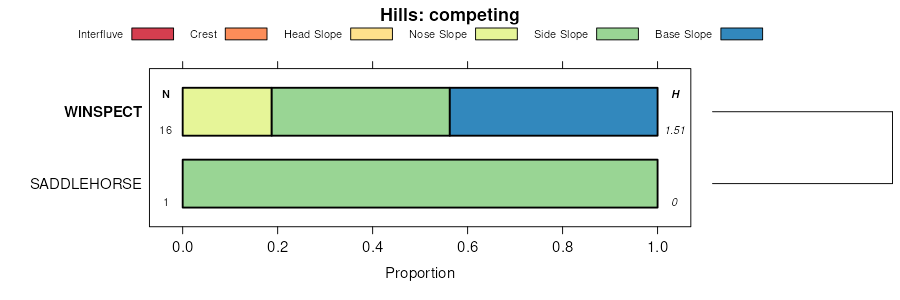
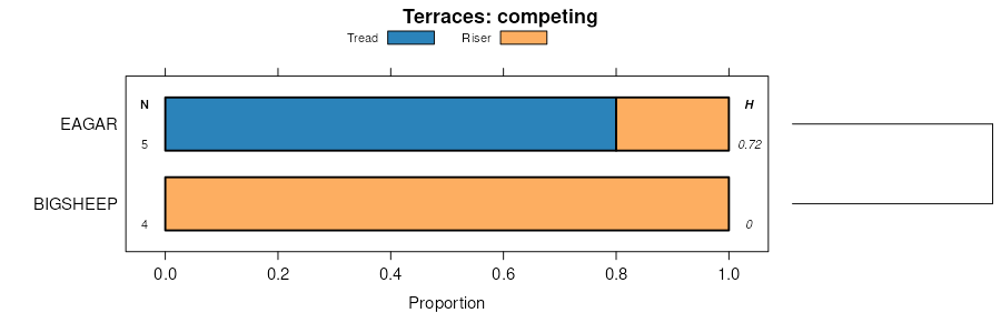
Winspect-Kiev-Bigsheep families, complex, 15 to 40 percent slopes | 618 | 179 | 1862628 | 20j6s | wy647 | | 1:24000 |
Winspect-Kiev-Bigsheep families, complex, 15 to 40 percent slopes | 15L | 10879 | 157750 | 594q | wy656 | 2008 | 1:24000 |
Corbly-Winspect families-Rock outcrop complex, 7 to 60 percent slopes | 351L | 3593 | 1683197 | 1thhp | wy656 | 2008 | 1:24000 |
Campspass-like-Winspect-Mcmannamy-like complex, 15 to 35 percent slopes | 9446 | 88 | 3250537 | 2zv6j | wy656 | 2008 | 1:24000 |
Maryjane-like-Winspect-Sixbeacon complex, 15 to 75 percent slopes | 4503 | 17 | 3302896 | 2zdr8 | wy656 | 2008 | 1:24000 |


