Bacbuster-Bigbear-Vershal, very channery complex, 4 to 15 percent slopes
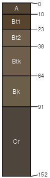
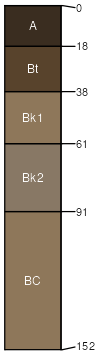
Bacbuster
(30%)
Upland Sagebrush Shrubland
Typic Argiustolls
Well drained
Hydric: No
PAWS: 14 cm
hills / Backslope
hills / Footslope
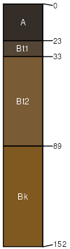
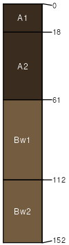
Bigbear
(20%)
Upland Sagebrush Shrubland
Typic Argiustolls
Well drained
Hydric: No
PAWS: 23 cm
hills / Footslope
hills / Toeslope
swales
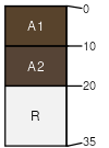
Vershal
(20%)
Shallow Sagebrush Shrubland
Lithic Haplustolls
Well drained
Hydric: No
PAWS: 1 cm
hills / Summit
hills / Shoulder
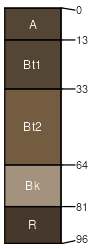
Absarook
(10%)
Loamy (Lo) 15-19 PZ Frigid North
Typic Argiustolls
Well drained
Hydric: No
PAWS: 15 cm
hills / Backslope
hills / Toeslope
Farnuf
(10%)
Loamy (Lo) 15-19 PZ Frigid North
Typic Argiustolls
Well drained
Hydric: No
PAWS: 24 cm
swales
hills / Footslope
hills / Toeslope
Bowery
(5%)
Overflow (Ov) 15-19 PZ Frigid North
Pachic Haplustolls
Well drained
Hydric: No
PAWS: 25 cm
swales
hills
Rock outcrop
(5%)
Hydric:
PAWS: NA
SSA
Scale
Published
Export
mt669
1:24,000
2025-09-03