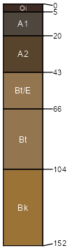
Bachus (29%)
Upland Grassland Group
Pachic Argicryolls
Well drained
Hydric: No
PAWS: 9 cm |

mountain slopes / Backslope mountain slopes / Footslope
|
|
Gilispie (25%)
Shallow Sagebrush Shrubland Group
Lithic Argicryolls
Well drained
Hydric: No
PAWS: 5 cm |

mountain slopes / Summit mountain slopes / Shoulder mountain slopes / Backslope
|
|
Tophat (15%)
Upland Grassland Group
Pachic Argicryolls
Well drained
Hydric: No
PAWS: 21 cm |
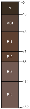
mountain slopes / Backslope mountain slopes / Footslope
|
|
Dalys (10%)
Shallow Shrubland Group
Lithic Haplocryolls
Well drained
Hydric: No
PAWS: 1 cm |
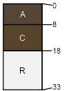
mountain slopes / Shoulder mountain slopes / Backslope
|
|
Decross (10%)
Upland Grassland Group
Pachic Argicryolls
Well drained
Hydric: No
PAWS: 27 cm |

mountain slopes / Backslope mountain slopes / Footslope
|
|
Duckcreek (10%)
Upland Grassland Group
Ustic Argicryolls
Well drained
Hydric: No
PAWS: 15 cm |
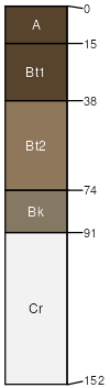
mountain slopes / Backslope mountain slopes / Footslope
|
|
|