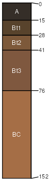
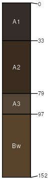
Libeg-Copenhaver-Rock outcrop complex, 15 to 35 percent slopes, moderately impacted

Libeg (40%)
Upland Sagebrush Shrubland
Ustic Argicryolls
Well drained
Hydric: No
PAWS: 12 cm
terraces
alluvial fans
hills
Copenhaver (25%)
Shallow Sagebrush Shrubland Group
Lithic Argicryolls
Well drained
Hydric: No
PAWS: 3 cm
hills / Backslope
Rock outcrop (20%)


Hydric: No
PAWS: NA
Adel (4%)
Pachic Haplocryolls
Well drained
Hydric: No
PAWS: 26 cm
alluvial fans
drainageways
Monad (4%)
Alfic Argicryolls
Well drained
Hydric: No
PAWS: 21 cm
stream terraces
Mollet (4%)
Ustic Argicryolls
Well drained
Hydric: No
PAWS: 20 cm
fans
mountains
terraces
Redchief (3%)
Ustic Argicryolls
Well drained
Hydric: No
PAWS: 18 cm
mountains
hills / Footslope
hills / Backslope
SSAScalePublishedExport
mt6161:24,00020032023-08-25