Regent-Castner complex, 8 to 35 percent slopes
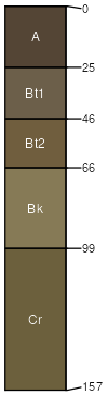
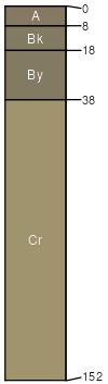
Regent
(65%)
Upland Sagebrush Shrubland Group
Vertic Argiustolls
Well drained
Hydric: No
PAWS: 13 cm
hills
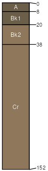
Castner
(20%)
Shallow Grassland Group
Lithic Haplustolls
Well drained
Hydric: No
PAWS: 3 cm
hills
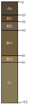
Reeder
(3%)
Loamy (Lo) 15-19 PZ Frigid North
Typic Argiustolls
Well drained
Hydric: No
PAWS: 15 cm
hills
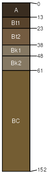
Hilger
(3%)
Droughty (Dr) 15-19 PZ Frigid North
Typic Argiustolls
Well drained
Hydric: No
PAWS: 10 cm
alluvial fans
Wayden
(3%)
Shallow Clay (SwC) 15-19 PZ Frigid North
Typic Ustorthents
Well drained
Hydric: No
PAWS: 6 cm
hills
Castner
(3%)
Shallow Sagebrush Shrubland Group
Lithic Haplustolls
Well drained
Hydric: No
PAWS: 3 cm
hills
Rock outcrop
(2%)
Hydric: No
PAWS: NA
Cabba
(1%)
Shallow (Sw) RRU 46-N 13-19 PZ
Typic Ustorthents
Well drained
Hydric: No
PAWS: 8 cm
hills
SSA
Scale
Published
Export
mt630
1:24,000
1991
2025-08-30