| Regent-Wyola silty clay loams, 3 to 6 percent slopes | E1025B | 3394 | 342205 | 1vzsn | mt025 | 1991 | 1:24000 |
Regent silty clay loam, 2 to 8 percent slopes | 187 | 3666 | 342420 | ch9t | mt027 | 1979 | 1:24000 |
Regent silty clay, 2 to 8 percent slopes | 188 | 3621 | 342421 | ch9v | mt027 | 1979 | 1:24000 |
Regent-Wyola silty clay loams, 3 to 6 percent slopes | E1025B | 19583 | 345649 | 1vzsn | mt109 | 1956 | 1:31680 |
Midway-Regent silty clay loams, 3 to 7 percent slopes | Me | 9726 | 345639 | clnn | mt109 | 1956 | 1:31680 |
Regent-Wyola silty clay loams, 6 to 9 percent slopes | E1025C | 5786 | 345650 | 1vzsp | mt109 | 1956 | 1:31680 |
Midway-Regent silty clay loams, 8 to 11 percent slopes | Mg | 2368 | 345640 | clnp | mt109 | 1956 | 1:31680 |
Regent-Wyola silty clay loams, 0 to 3 percent slopes | E1025A | 1504 | 345648 | 1vzsm | mt109 | 1956 | 1:31680 |
Midway-Regent silty clay loams, 12 to 15 percent slopes | Mh | 347 | 345641 | clnq | mt109 | 1956 | 1:31680 |
Wayden-Regent silty clay loams, hilly | WI | 29665 | 346216 | cm88 | mt607 | 1970 | 1:24000 |
Wayden-Rock outcrop complex, rolling | WL | 25159 | 346218 | cm8b | mt607 | 1970 | 1:24000 |
Reeder-Regent complex, rolling | REa | 6337 | 346105 | cm4p | mt607 | 1970 | 1:24000 |
Amherst-Regent complex, 15 to 35 percent slopes | AVc | 5901 | 345849 | 3106k | mt607 | 1970 | 1:24000 |
Regent silty clay loam, undulating | Rfc | 5091 | 346123 | cm58 | mt607 | 1970 | 1:24000 |
Regent silty clay loam, rolling | Rfd | 4903 | 346124 | cm59 | mt607 | 1970 | 1:24000 |
Regent silty clay loam, gently undulating | Rfa | 3340 | 346122 | cm57 | mt607 | 1970 | 1:24000 |
Wayden-Wyola silty clay loams, rolling | WK | 2667 | 346217 | cm89 | mt607 | 1970 | 1:24000 |
Reeder-Regent-Cabba loams, 2 to 8 percent slopes | 380C | 36926 | 147798 | 4ysp | mt630 | 1991 | 1:24000 |
Reeder-Regent-Cabba loams, 8 to 25 percent slopes | 380D | 35494 | 147799 | 4ysq | mt630 | 1991 | 1:24000 |
Reeder-Regent-Castner complex, 8 to 25 percent slopes | 280D | 29602 | 147770 | 4yrs | mt630 | 1991 | 1:24000 |
Regent-Reeder-Work stony loams, 4 to 30 percent slopes | 178D | 14188 | 147720 | 4yq5 | mt630 | 1991 | 1:24000 |
Regent-Auchard loams, 2 to 8 percent slopes | 278C | 9689 | 147768 | 4yrq | mt630 | 1991 | 1:24000 |
Wayden-Cabba-Regent complex, 15 to 45 percent slopes | 679E | 8235 | 147884 | 4ywg | mt630 | 1991 | 1:24000 |
Regent-Castner complex, 8 to 35 percent slopes | 180D | 7774 | 147722 | 4yq7 | mt630 | 1991 | 1:24000 |
Regent-Wayden-Cabba complex, 15 to 45 percent slopes | 479E | 5230 | 147825 | 4ytk | mt630 | 1991 | 1:24000 |
Regent-Wayden complex, 8 to 35 percent slopes | 879E | 3684 | 147927 | 4yxv | mt630 | 1991 | 1:24000 |
Regent clay loam, 2 to 10 percent slopes | 80C | 3209 | 147916 | 4yxh | mt630 | 1991 | 1:24000 |
Regent-Sinnigam complex, 8 to 35 percent slopes | 780E | 3134 | 147908 | 4yx7 | mt630 | 1991 | 1:24000 |
Sinnigam-Regent complex, 15 to 45 percent slopes | 779E | 3095 | 147906 | 4yx5 | mt630 | 1991 | 1:24000 |
Regent-Fairfield-Winspect stony loams, 8 to 35 percent slopes | 743D | 3068 | 147901 | 4yx0 | mt630 | 1991 | 1:24000 |
Hilger-Regent-Castner stony loams, 15 to 35 percent slopes | 961E | 2885 | 147942 | 4yyb | mt630 | 1991 | 1:24000 |
Regent-Lap complex, 8 to 45 percent slopes | 979E | 1851 | 147946 | 4yyg | mt630 | 1991 | 1:24000 |
Regent-Wyola silty clay loams, 3 to 6 percent slopes | E1025B | 16906 | 2525730 | 1vzsn | nd001 | 1983 | 1:20000 |
Regent-Moreau-Cabba complex, 6 to 9 percent slopes | E1031C | 6249 | 2525731 | 2q64g | nd001 | 1983 | 1:20000 |
Regent-Janesburg complex, 3 to 6 percent slopes | E0651B | 64 | 2755636 | 1vzrt | nd001 | 1983 | 1:20000 |
Regent-Wyola silty clay loams, 0 to 3 percent slopes | E1025A | 22 | 2755641 | 1vzsm | nd001 | 1983 | 1:20000 |
Regent-Janesburg complex, 0 to 3 percent slopes | E0651A | 15 | 2755635 | 1vzrs | nd001 | 1983 | 1:20000 |
Regent-Wyola silty clay loams, 3 to 6 percent slopes | E1025B | 628 | 1715173 | 1vzsn | nd007 | 1998 | 1:24000 |
Regent-Janesburg complex, 3 to 6 percent slopes | E0651B | 124 | 1715167 | 1vzrt | nd007 | 1998 | 1:24000 |
Regent-Janesburg complex, 0 to 3 percent slopes | E0651A | 39 | 1715166 | 1vzrs | nd007 | 1998 | 1:24000 |
Regent-Janesburg complex, 6 to 9 percent slopes | E0651C | 33 | 1715168 | 1vzrv | nd007 | 1998 | 1:24000 |
Regent-Wyola silty clay loams, 3 to 6 percent slopes | E1025B | 6778 | 2563601 | 1vzsn | nd011 | 1969 | 1:20000 |
Regent-Janesburg complex, 3 to 6 percent slopes | E0651B | 6169 | 2563598 | 1vzrt | nd011 | 1969 | 1:20000 |
Regent-Wyola silty clay loams, 0 to 3 percent slopes | E1025A | 2397 | 2563600 | 1vzsm | nd011 | 1969 | 1:20000 |
Regent-Janesburg complex, 0 to 3 percent slopes | E0651A | 1770 | 2563597 | 1vzrs | nd011 | 1969 | 1:20000 |
Regent-Moreau-Cabba complex, 6 to 9 percent slopes | E1031C | 905 | 2563599 | 2q64g | nd011 | 1969 | 1:20000 |
Regent-Moreau-Dogtooth complex, 3 to 9 percent slopes | RlB | 288 | 992887 | 12b5m | nd011 | 1969 | 1:20000 |
Regent silty clay loam, 0 to 3 percent slopes | RhA | 112 | 992884 | 12b5j | nd011 | 1969 | 1:20000 |
Regent silty clay loam, 3 to 6 percent slopes | RhB | 60 | 992885 | 12b5k | nd011 | 1969 | 1:20000 |
Regent-Moreau silty clay loams, 6 to 9 percent slopes | RkC | 35 | 992886 | 12b5l | nd011 | 1969 | 1:20000 |
Regent-Wyola silty clay loams, 3 to 6 percent slopes | C954B | 1253 | 2564190 | 2q77n | nd015 | 1967 | 1:20000 |
Regent-Wyola silty clay loams, 6 to 9 percent slopes | C954C | 858 | 2596906 | 2qygc | nd015 | 1967 | 1:20000 |
Regent-Wyola silty clay loams, 6 to 9 percent slopes | E1025C | 550 | 2661692 | 1vzsp | nd015 | 1967 | 1:20000 |
Regent-Wyola silty clay loams, 3 to 6 percent slopes | E1025B | 334 | 2661747 | 1vzsn | nd015 | 1967 | 1:20000 |
Regent-Janesburg complex, 3 to 6 percent slopes | E0651B | 17945 | 1713160 | 1vzrt | nd025 | 1981 | 1:20000 |
Regent-Wyola silty clay loams, 3 to 6 percent slopes | E1025B | 10807 | 1714624 | 1vzsn | nd025 | 1981 | 1:20000 |
Regent-Janesburg complex, 0 to 3 percent slopes | E0651A | 7069 | 2707177 | 1vzrs | nd025 | 1981 | 1:20000 |
Regent-Janesburg complex, 6 to 9 percent slopes | E0651C | 4566 | 1713161 | 1vzrv | nd025 | 1981 | 1:20000 |
Regent-Wyola silty clay loams, 6 to 9 percent slopes | E1025C | 3271 | 2707195 | 1vzsp | nd025 | 1981 | 1:20000 |
Regent-Wyola silty clay loams, 0 to 3 percent slopes | E1025A | 848 | 2707194 | 1vzsm | nd025 | 1981 | 1:20000 |
Regent-Wyola silty clay loams, 3 to 6 percent slopes | E1025B | 2939 | 2661770 | 1vzsn | nd029 | 1979 | 1:20000 |
Regent-Janesburg complex, 3 to 6 percent slopes | E0651B | 2428 | 2661767 | 1vzrt | nd029 | 1979 | 1:20000 |
Regent-Janesburg complex, 6 to 9 percent slopes | E0651C | 1958 | 2661768 | 1vzrv | nd029 | 1979 | 1:20000 |
Regent-Cabba complex, 6 to 9 percent slopes | E0921C | 1867 | 2661760 | cdtn | nd029 | 1979 | 1:20000 |
Regent-Cabba complex, 9 to 15 percent slopes | E0921D | 588 | 2661803 | 2q647 | nd029 | 1979 | 1:20000 |
Regent-Wyola silty clay loams, 0 to 3 percent slopes | E1025A | 292 | 2661769 | 1vzsm | nd029 | 1979 | 1:20000 |
Regent-Wyola silty clay loams, 3 to 6 percent slopes | C954B | 205 | 2596935 | 2q77n | nd029 | 1979 | 1:20000 |
Regent-Wyola silty clay loams, 6 to 9 percent slopes | C954C | 128 | 2596939 | 2qygc | nd029 | 1979 | 1:20000 |
Regent-Wyola silty clay loams, 0 to 3 percent slopes | C954A | 113 | 2596937 | 2q6mj | nd029 | 1979 | 1:20000 |
Regent-Wyola silty clay loams, 3 to 6 percent slopes | E1025B | 774 | 2707279 | 1vzsn | nd033 | 1985 | 1:24000 |
Regent-Wyola silty clay loams, 3 to 6 percent slopes | E1025B | 47619 | 2525864 | 1vzsn | nd037 | 1985 | 1:20000 |
Regent-Janesburg complex, 3 to 6 percent slopes | E0651B | 17365 | 2525859 | 1vzrt | nd037 | 1985 | 1:20000 |
Regent-Wyola silty clay loams, 6 to 9 percent slopes | E1025C | 9131 | 1715487 | 1vzsp | nd037 | 1985 | 1:20000 |
Regent-Janesburg complex, 6 to 9 percent slopes | E0651C | 1854 | 1715484 | 1vzrv | nd037 | 1985 | 1:20000 |
Regent-Moreau-Cabba complex, 6 to 9 percent slopes | E1031C | 17 | 2759637 | 2q64g | nd037 | 1985 | 1:20000 |
Regent-Janesburg complex, 0 to 3 percent slopes | E0651A | 13 | 2759633 | 1vzrs | nd037 | 1985 | 1:20000 |
Regent-Wyola silty clay loams, 3 to 6 percent slopes | E1025B | 36031 | 1718590 | 1vzsn | nd041 | 1986 | 1:20000 |
Regent-Moreau-Cabba complex, 6 to 9 percent slopes | E1031C | 14891 | 2525790 | 2q64g | nd041 | 1986 | 1:20000 |
Regent-Janesburg complex, 3 to 6 percent slopes | E0651B | 10581 | 1718580 | 1vzrt | nd041 | 1986 | 1:20000 |
Regent-Wyola silty clay loams, 0 to 3 percent slopes | E1025A | 6972 | 1718589 | 1vzsm | nd041 | 1986 | 1:20000 |
Regent-Janesburg complex, 0 to 3 percent slopes | E0651A | 3734 | 1718579 | 1vzrs | nd041 | 1986 | 1:20000 |
Regent-Wyola silty clay loams, 3 to 6 percent slopes | E1025B | 1650 | 2661855 | 1vzsn | nd047 | 1992 | 1:20000 |
Regent-Wyola silty clay loams, 3 to 6 percent slopes | C954B | 853 | 2595511 | 2q77n | nd047 | 1992 | 1:20000 |
Regent-Wyola silty clay loams, 0 to 3 percent slopes | E1025A | 41 | 2661854 | 1vzsm | nd047 | 1992 | 1:20000 |
Regent-Wyola silty clay loams, 3 to 6 percent slopes | C954B | 2813 | 2595532 | 2q77n | nd051 | 1992 | 1:24000 |
Regent-Wyola silty clay loams, 3 to 6 percent slopes | E1025B | 400 | 2661992 | 1vzsn | nd051 | 1992 | 1:24000 |
Regent-Wyola silty clay loams, 0 to 3 percent slopes | C954A | 309 | 2595533 | 2q6mj | nd051 | 1992 | 1:24000 |
Regent-Wyola silty clay loams, 0 to 3 percent slopes | E1025A | 53 | 2661991 | 1vzsm | nd051 | 1992 | 1:24000 |
Regent-Janesburg complex, 3 to 6 percent slopes | E0651B | 2294 | 2715037 | 1vzrt | nd053 | 2003 | 1:24000 |
Regent-Janesburg complex, 6 to 9 percent slopes | E0651C | 1992 | 2715038 | 1vzrv | nd053 | 2003 | 1:24000 |
Regent-Wyola silty clay loams, 3 to 6 percent slopes | E1025B | 1677 | 2715049 | 1vzsn | nd053 | 2003 | 1:24000 |
Regent-Cabba complex, 6 to 9 percent slopes | E0921C | 929 | 2715046 | cdtn | nd053 | 2003 | 1:24000 |
Regent-Moreau-Cabba complex, 6 to 9 percent slopes | E1031C | 8 | 2759712 | 2q64g | nd053 | 2003 | 1:24000 |
Regent-Wyola silty clay loams, 6 to 9 percent slopes | E1025C | 935 | 2662452 | 1vzsp | nd055 | 1974 | 1:20000 |
Regent-Wyola silty clay loams, 6 to 9 percent slopes | C954C | 278 | 2597001 | 2qygc | nd055 | 1974 | 1:20000 |
Regent-Wyola silty clay loams, 3 to 6 percent slopes | E1025B | 24 | 2662451 | 1vzsn | nd055 | 1974 | 1:20000 |
Regent-Janesburg complex, 3 to 6 percent slopes | E0651B | 5629 | 1715099 | 1vzrt | nd057 | 1976 | 1:20000 |
Regent-Janesburg complex, 6 to 9 percent slopes | E0651C | 2838 | 2755722 | 1vzrv | nd057 | 1976 | 1:20000 |
Regent-Wyola silty clay loams, 3 to 6 percent slopes | E1025B | 812 | 2699306 | 1vzsn | nd057 | 1976 | 1:20000 |
Regent-Wyola silty clay loams, 6 to 9 percent slopes | E1025C | 629 | 2699307 | 1vzsp | nd057 | 1976 | 1:20000 |
Regent-Janesburg complex, 0 to 3 percent slopes | E0651A | 617 | 2699305 | 1vzrs | nd057 | 1976 | 1:20000 |
Regent-Janesburg complex, 3 to 6 percent slopes | E0651B | 33664 | 1718331 | 1vzrt | nd059 | 1998 | 1:20000 |
Regent-Janesburg complex, 6 to 9 percent slopes | E0651C | 16069 | 1718332 | 1vzrv | nd059 | 1998 | 1:20000 |
Regent-Wyola silty clay loams, 3 to 6 percent slopes | E1025B | 7730 | 2699200 | 1vzsn | nd059 | 1998 | 1:20000 |
Regent-Wyola silty clay loams, 6 to 9 percent slopes | E1025C | 5313 | 2759666 | 1vzsp | nd059 | 1998 | 1:20000 |
Regent-Janesburg complex, 0 to 3 percent slopes | E0651A | 3916 | 2699198 | 1vzrs | nd059 | 1998 | 1:20000 |
Regent-Wyola silty clay loams, 0 to 3 percent slopes | E1025A | 1348 | 2699199 | 1vzsm | nd059 | 1998 | 1:20000 |
Regent-Janesburg complex, 3 to 6 percent slopes | E0651B | 5747 | 2525906 | 1vzrt | nd065 | 1971 | 1:20000 |
Regent-Wyola silty clay loams, 3 to 6 percent slopes | E1025B | 3539 | 2525917 | 1vzsn | nd065 | 1971 | 1:20000 |
Regent-Janesburg complex, 0 to 3 percent slopes | E0651A | 1834 | 2525905 | 1vzrs | nd065 | 1971 | 1:20000 |
Regent-Wyola silty clay loams, 6 to 9 percent slopes | E1025C | 1611 | 2525918 | 1vzsp | nd065 | 1971 | 1:20000 |
Regent-Janesburg complex, 6 to 9 percent slopes | E0651C | 1266 | 2525907 | 1vzrv | nd065 | 1971 | 1:20000 |
Regent-Wyola silty clay loams, 0 to 3 percent slopes | E1025A | 258 | 2525916 | 1vzsm | nd065 | 1971 | 1:20000 |
Regent-Janesburg complex, 3 to 6 percent slopes | E0651B | 26469 | 2699117 | 1vzrt | nd085 | 1992 | 1:24000 |
Dogtooth-Janesburg-Regent complex, 6 to 15 percent slopes | E0705D | 21737 | 2699080 | d1x3 | nd085 | 1992 | 1:24000 |
Janesburg-Regent-Cabba complex, 9 to 35 percent slopes | E0707F | 17436 | 2699098 | d1xt | nd085 | 1992 | 1:24000 |
Regent-Janesburg complex, 6 to 9 percent slopes | E0651C | 12060 | 2699118 | 1vzrv | nd085 | 1992 | 1:24000 |
Regent-Reeder complex, 3 to 6 percent slopes | E1043B | 5770 | 2699120 | d1xw | nd085 | 1992 | 1:24000 |
Regent-Wyola silty clay loams, 3 to 6 percent slopes | E1025B | 3356 | 2699122 | 1vzsn | nd085 | 1992 | 1:24000 |
Regent-Wyola silty clay loams, 6 to 9 percent slopes | E1025C | 2375 | 2699123 | 1vzsp | nd085 | 1992 | 1:24000 |
Moreau-Regent silty clay loams, 3 to 6 percent slopes | E1017B | 2001 | 2699109 | d1xq | nd085 | 1992 | 1:24000 |
Regent-Wyola silty clay loams, 0 to 3 percent slopes | E1025A | 1604 | 2699121 | 1vzsm | nd085 | 1992 | 1:24000 |
Regent-Janesburg complex, 0 to 3 percent slopes | E0651A | 845 | 2699116 | 1vzrs | nd085 | 1992 | 1:24000 |
Regent-Reeder complex, 0 to 3 percent slopes | E1043A | 806 | 2699119 | d1xv | nd085 | 1992 | 1:24000 |
Moreau-Regent silty clay loams, 3 to 6 percent slopes | 2320 | 43 | 337823 | cbjj | nd085 | 1992 | 1:24000 |
Regent-Wayden silty clay loams, 6 to 15 percent slopes | E0923D | 41 | 2759700 | 2r4fx | nd085 | 1992 | 1:24000 |
Janesburg-Regent-Cabba complex, 9 to 35 percent slopes | 2323 | 32 | 337826 | cbjm | nd085 | 1992 | 1:24000 |
Regent-Wyola silty clay loams, 6 to 9 percent slopes | 1498 | 25 | 337765 | cbgn | nd085 | 1992 | 1:24000 |
Regent-Janesburg complex, 3 to 6 percent slopes | E0651B | 6304 | 1716773 | 1vzrt | nd087 | 1974 | 1:20000 |
Regent-Wyola silty clay loams, 3 to 6 percent slopes | E1025B | 6268 | 1716778 | 1vzsn | nd087 | 1974 | 1:20000 |
Regent-Wyola silty clay loams, 0 to 3 percent slopes | E1025A | 2867 | 2707392 | 1vzsm | nd087 | 1974 | 1:20000 |
Regent-Janesburg complex, 0 to 3 percent slopes | E0651A | 2748 | 2707373 | 1vzrs | nd087 | 1974 | 1:20000 |
Regent-Janesburg complex, 6 to 9 percent slopes | E0651C | 1007 | 2758507 | 1vzrv | nd087 | 1974 | 1:20000 |
Regent-Janesburg complex, 3 to 6 percent slopes | E0651B | 24068 | 1713468 | 1vzrt | nd089 | 1965 | 1:20000 |
Regent-Wyola silty clay loams, 3 to 6 percent slopes | E1025B | 9729 | 1713494 | 1vzsn | nd089 | 1965 | 1:20000 |
Regent-Janesburg complex, 6 to 9 percent slopes | E0651C | 6961 | 1713469 | 1vzrv | nd089 | 1965 | 1:20000 |
Regent-Janesburg complex, 0 to 3 percent slopes | E0651A | 5122 | 1713467 | 1vzrs | nd089 | 1965 | 1:20000 |
Regent-Wyola silty clay loams, 0 to 3 percent slopes | E1025A | 2073 | 1713493 | 1vzsm | nd089 | 1965 | 1:20000 |
Regent-Wyola silty clay loams, 6 to 9 percent slopes | E1025C | 327 | 1713495 | 1vzsp | nd089 | 1965 | 1:20000 |
Moreau-Regent complex, 3 to 9 percent slopes, very stony | E6101C | 238 | 2716032 | 2r4fs | nd089 | 1965 | 1:20000 |
Regent-Wyola silty clay loams, 3 to 6 percent slopes | RnB | 47390 | 356199 | 1vzsn | sd031 | 1986 | 1:24000 |
Regent-Wayden silty clay loams, 6 to 15 percent slopes | RpC | 19948 | 356200 | cynb | sd031 | 1986 | 1:24000 |
Regent silty clay loam, 0 to 2 percent slopes | RnA | 2998 | 3079014 | cyn8 | sd031 | 1986 | 1:24000 |
Janesburg-Regent-Cabba complex, 9 to 35 percent slopes | JrF | 79 | 1386974 | 1hk83 | sd031 | 1986 | 1:24000 |
Regent-Ridgeview silty clay loams, 2 to 6 percent slopes | RpB | 35658 | 354231 | cwlt | sd041 | 1972 | 1:24000 |
Regent-Moreau complex, 2 to 9 percent slopes | RmB | 11714 | 354229 | cwlr | sd041 | 1972 | 1:24000 |
Regent silty clay loam, 6 to 9 percent slopes | RgC | 3619 | 354228 | 2yntr | sd041 | 1972 | 1:24000 |
Regent-Ridgeview silty clay loams, 0 to 2 percent slopes | RpA | 2389 | 354230 | cwls | sd041 | 1972 | 1:24000 |
Regent-Wyola silty clay loams, 3 to 6 percent slopes | RfB | 54471 | 354652 | 1vzsn | sd105 | 1977 | 1:24000 |
Regent-Daglum complex, 3 to 6 percent slopes | ReB | 38626 | 354651 | 2yntq | sd105 | 1977 | 1:24000 |
Regent-Wayden silty clay loams, 6 to 15 percent slopes | RhD | 11541 | 354653 | cx1f | sd105 | 1977 | 1:24000 |
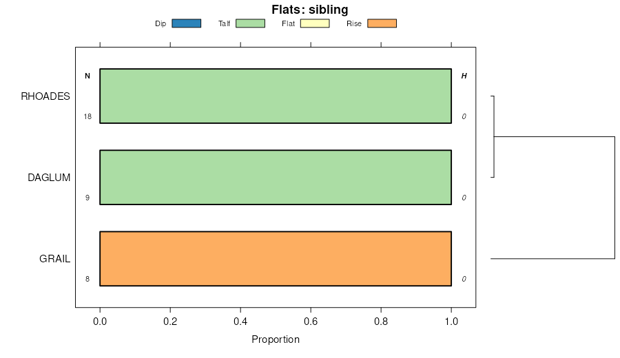
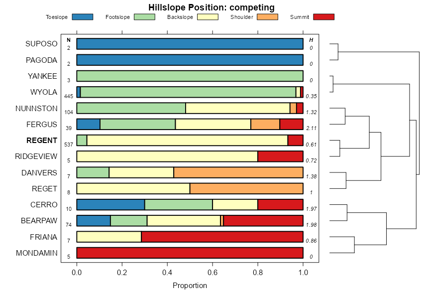
Regent-Rhoades complex, 2 to 9 percent slopes | RnB | 52652 | 355877 | cy9x | sd137 | 1985 | 1:24000 |
Regent silty clay loam, 3 to 6 percent slopes | RgB | 46383 | 355873 | 2ynts | sd137 | 1985 | 1:24000 |
Regent silty clay loam, 6 to 9 percent slopes | RgC | 14410 | 355874 | 2yntr | sd137 | 1985 | 1:24000 |
Regent-Daglum complex, 3 to 6 percent slopes | RmB | 3658 | 355876 | 2yntq | sd137 | 1985 | 1:24000 |
Regent-Cabba complex, 6 to 15 percent slopes | RhD | 3447 | 355875 | cy9v | sd137 | 1985 | 1:24000 |
