Deer Park-Deford-Tawas complex, 0 to 60 percent slopes
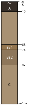
Deer Park
(60%)
Dry Upland
Spodic Udipsamments
Excessively drained
Hydric: No
PAWS: 15 cm
dunes / Summit
dunes / Shoulder
dunes / Backslope
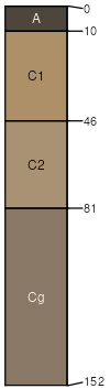
Deford
(20%)
Wet Sandy Lowland
Typic Psammaquents
Poorly drained
Hydric: Yes
PAWS: 18 cm
swales / Toeslope
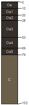
Tawas
(15%)
Mucky Swamp
Terric Haplosaprists
Very poorly drained
Hydric: Yes
PAWS: 37 cm
depressions / Toeslope
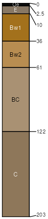
Wurtsmith
(5%)
Sandy Upland
Oxyaquic Udipsamments
Moderately well drained
Hydric: No
PAWS: 13 cm
beach ridges / Backslope
beach ridges / Footslope
beach ridges / Toeslope
SSA
Scale
Published
Export
mi153
1:24,000
2007
2025-09-04