| Tawas-Deford mucks | 93 | 11829 | 1455305 | 1kvcb | mi003 | 2007 | 1:24000 |
Deford and Leafriver soils, 0 to 2 percent slopes | 19 | 752 | 1455254 | 2xxj3 | mi003 | 2007 | 1:24000 |
Wurtsmith-Deford complex, 0 to 6 percent slopes | 298B | 226 | 1455433 | 1kvhg | mi003 | 2007 | 1:24000 |
Deford muck | 369 | 18209 | 191274 | 6f14 | mi007 | 1998 | 1:12000 |
Au Gres-Deford complex, 0 to 3 percent slopes | 368A | 6533 | 191342 | 6f3b | mi007 | 1998 | 1:12000 |
Proper-Deford-Rousseau complex, 0 to 40 percent slopes | 396F | 4444 | 191281 | 6f1c | mi007 | 1998 | 1:12000 |
Deford muck, 0 to 2 percent slopes | DefaaA | 1852 | 3155899 | 2ytj8 | mi009 | 1976 | 1:15840 |
Au Gres-Deford complex, 0 to 3 percent slopes | AugdeA | 1521 | 3155891 | 2ytj7 | mi009 | 1976 | 1:15840 |
Deford loamy fine sand | Dn | 3646 | 189147 | 6btj | mi011 | 1964 | 1:20000 |
Deford loam | Dm | 219 | 189146 | 6bth | mi011 | 1964 | 1:20000 |
Deford and Leafriver soils, 0 to 2 percent slopes | 8114 | 181 | 2441894 | 2xxj3 | mi013 | 1984 | 1:20000 |
Deford muck, 0 to 2 percent slopes | DefaaA | 7 | 3156015 | 2ytj8 | mi029 | 1970 | 1:15840 |
Deford and Leafriver soils, 0 to 2 percent slopes | 50 | 10534 | 415159 | 2xxj3 | mi033 | 1989 | 1:15840 |
Deford and Leafriver soils, 0 to 2 percent slopes | Dm | 670 | 1588042 | 2xxj3 | mi041 | 1969 | 1:24000 |
Deford and Leafriver soils, 0 to 2 percent slopes | 26 | 4348 | 415212 | 2xxj3 | mi043 | 1985 | 1:20000 |
Deford loamy fine sand | Df | 306 | 189323 | 6c06 | mi047 | 1968 | 1:20000 |
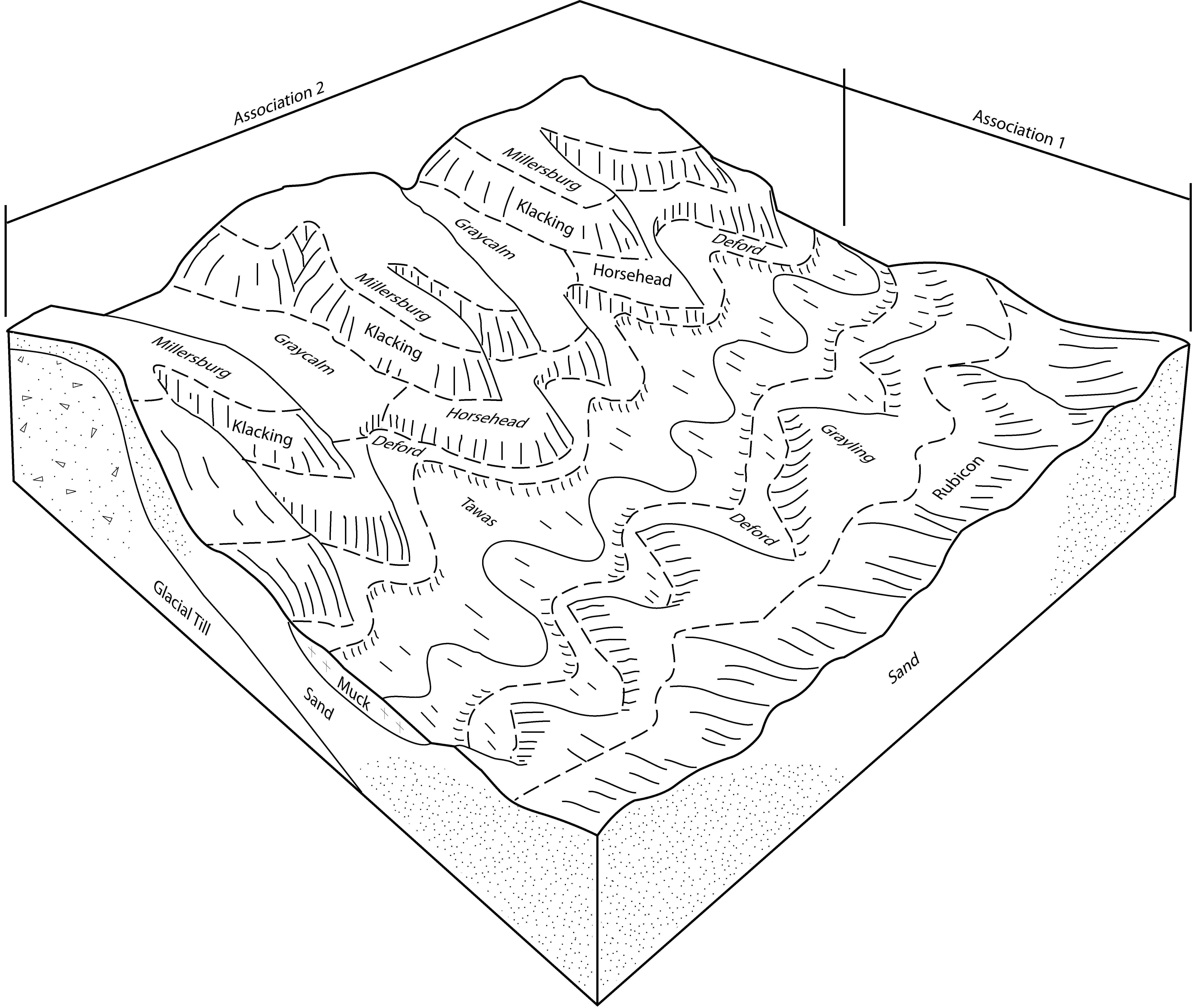
Roscommon-Deford association | RD | 4258 | 189847 | 6ck3 | mi051 | 1966 | 1:15840 |
Wainola-Deford association | WD | 1419 | 189865 | 6ckp | mi051 | 1966 | 1:15840 |
Deford and Leafriver soils, 0 to 2 percent slopes | 650 | 276 | 1456226 | 2xxj3 | mi053 | 2007 | 1:24000 |
Deford-Tawas complex, 0 to 1 percent slopes | 77 | 10564 | 416160 | fz1j | mi061 | 1989 | 1:20000 |
Deford and Leafriver soils, 0 to 2 percent slopes | 67 | 2168 | 416151 | 2xxj3 | mi061 | 1989 | 1:20000 |
Ingalls-Deford complex, 0 to 4 percent slopes | 8156A | 846 | 2484795 | 2pdmp | mi061 | 1989 | 1:20000 |
Deford muck | 369 | 14008 | 191832 | 6fm4 | mi069 | 1995 | 1:15840 |
Au Gres-Deford complex, 0 to 3 percent slopes | 368A | 7726 | 191831 | 6fm3 | mi069 | 1995 | 1:15840 |
Finch-Deford-Au Gres complex, 0 to 3 percent slopes | 409A | 1830 | 191855 | 6fmw | mi069 | 1995 | 1:15840 |
Proper-Finch-Deford complex, 0 to 6 percent slopes | 410B | 923 | 191857 | 6fmy | mi069 | 1995 | 1:15840 |
Au Gres-Deford complex, 0 to 3 percent slopes | AugdeA | 4 | 3187038 | 2ytj7 | mi079 | 1998 | 1:12000 |
Croswell, rarely flooded-Deford, frequently flooded complex, 0 to 6 percent slopes | 201B | 1728 | 631370 | p5zs | mi095 | 2004 | 1:24000 |
Deford and Leafriver soils, 0 to 2 percent slopes | 23 | 1084 | 627467 | 2xxj3 | mi095 | 2004 | 1:24000 |
Deford and Leafriver soils, 0 to 2 percent slopes | 23 | 12540 | 416379 | 2xxj3 | mi097 | 1994 | 1:20000 |
Wainola-Deford fine sands, 0 to 2 percent slopes | WdA | 24 | 2508668 | 6924 | mi099 | 1967 | 1:20000 |
Tawas-Deford mucks | 93 | 13492 | 395304 | f8br | mi103 | 1999 | 1:24000 |
Croswell-Deford complex, 0 to 3 percent slopes | 118A | 9344 | 394998 | f80w | mi103 | 1999 | 1:24000 |
Deford and Leafriver soils, 0 to 2 percent slopes | 19 | 2466 | 395146 | 2xxj3 | mi103 | 1999 | 1:24000 |
Au Gres-Deford complex, 0 to 3 percent slopes | 203A | 1955 | 395160 | f863 | mi103 | 1999 | 1:24000 |
Deford-Wainola-Rousseau complex, 0 to 12 percent slopes | 45C | 35413 | 415481 | fybm | mi109 | 1985 | 1:20000 |
Tawas-Deford complex | 44 | 21162 | 415480 | fybl | mi109 | 1985 | 1:20000 |
Deford and Leafriver soils, 0 to 2 percent slopes | 21 | 9067 | 415459 | 2xxj3 | mi109 | 1985 | 1:20000 |
Urban land-Deford complex | 34 | 1023 | 415472 | fybb | mi109 | 1985 | 1:20000 |
Wainola-Deford association | WD | 34 | 2673566 | 6ckp | mi111 | 1976 | 1:15840 |
Deford-Au Gres-Croswell complex, 0 to 6 percent slopes | 352B | 5519 | 192248 | 6g1k | mi119 | 1997 | 1:12000 |
Deford muck | 369 | 5161 | 192261 | 6g1z | mi119 | 1997 | 1:12000 |
Morganlake-Iosco-Deford complex, 0 to 6 percent slopes | 422B | 1640 | 192295 | 6g32 | mi119 | 1997 | 1:12000 |
Tonkey and Deford soils | Td | 5369 | 187384 | 68zn | mi121 | 1966 | 1:15840 |
Deford fine sand | Ds | 2027 | 187343 | 68yb | mi121 | 1966 | 1:15840 |
Deford-Tawas complex, 0 to 1 percent slopes | 90A | 1611 | 1456501 | 1kwlx | mi131 | 2007 | 1:24000 |
Au Gres-Deford complex, 0 to 3 percent slopes | 19A | 1062 | 1456400 | 1kwhn | mi131 | 2007 | 1:24000 |
Deford and Leafriver soils, 0 to 2 percent slopes | 30A | 709 | 1456409 | 2xxj3 | mi131 | 2007 | 1:24000 |
Ingalls-Deford complex, 0 to 4 percent slopes | 8156A | 131 | 1674845 | 1t6t8 | mi131 | 2007 | 1:24000 |
Deford-Au Gres-Croswell complex, 0 to 6 percent slopes | 352B | 7632 | 241413 | 836j | mi135 | 2003 | 1:12000 |
Au Gres-Deford complex, 0 to 3 percent slopes | 368A | 2125 | 209041 | 70j8 | mi135 | 2003 | 1:12000 |
Deford muck | 369 | 778 | 241423 | 836v | mi135 | 2003 | 1:12000 |
Deford muck | 369 | 768 | 191486 | 6f7z | mi137 | 1998 | 1:12000 |
Au Gres-Deford complex, 0 to 3 percent slopes | 368A | 650 | 191485 | 6f7y | mi137 | 1998 | 1:12000 |
Deford-Au Gres-Croswell complex, 0 to 6 percent slopes | 352B | 591 | 191483 | 6f7w | mi137 | 1998 | 1:12000 |
Deford muck | 369 | 5721 | 190986 | 6dqv | mi143 | 1999 | 1:12000 |
Augres-Deford complex, 0 to 3 percent slopes | 368A | 5132 | 190985 | 6dqt | mi143 | 1999 | 1:12000 |
Deford-Kinross mucks | 473 | 661 | 190974 | 6dqg | mi143 | 1999 | 1:12000 |
Proper-Finch-Deford complex, 0 to 6 percent slopes | 410B | 283 | 191044 | 6dsq | mi143 | 1999 | 1:12000 |
Wainola-Deford fine sands, 0 to 2 percent slopes | WdA | 25418 | 187461 | 6924 | mi147 | 1969 | 1:20000 |
Deford fine sand | De | 703 | 187412 | 690k | mi147 | 1969 | 1:20000 |
Wainola-Deford fine sands, 0 to 2 percent slopes | WfA | 25 | 2508316 | 6924 | mi151 | 1955 | 1:15840 |
Deford fine sand | De | 3 | 2508265 | 690k | mi151 | 1955 | 1:15840 |
Deford and Leafriver soils, 0 to 2 percent slopes | 63 | 24016 | 1456948 | 2xxj3 | mi153 | 2007 | 1:24000 |
Ausable, Deford, and Tawas mucks, frequently flooded | 65 | 17200 | 1457023 | 1kx4r | mi153 | 2007 | 1:24000 |
Deford-Rubicon-Au Gres complex, 0 to 15 percent slopes | 540D | 14779 | 1612304 | 1r3qt | mi153 | 2007 | 1:24000 |
Deford-Meehan-Seney complex, 0 to 3 percent slopes | 493A | 9526 | 1611884 | 1r398 | mi153 | 2007 | 1:24000 |
Rousseau-Neconish-Deford complex, 0 to 25 percent slopes | 22E | 7735 | 1538036 | 1nmg2 | mi153 | 2007 | 1:24000 |
Pelkie, occasionally flooded-Deford,frequently flooded, complex, 0 to 4 percent slopes | 67B | 6564 | 1456913 | 1kx16 | mi153 | 2007 | 1:24000 |
Au Gres-Deford complex, 0 to 3 percent slopes | 19A | 6506 | 1456938 | 1kx20 | mi153 | 2007 | 1:24000 |
Deer Park-Deford-Tawas complex, 0 to 60 percent slopes | 70F | 6206 | 1456952 | 1kx2g | mi153 | 2007 | 1:24000 |
Wurtsmith-Tawas-Deford complex, 0 to 6 percent slopes | 86B | 5847 | 1457029 | 1kx4y | mi153 | 2007 | 1:24000 |
Deford-Meehan complex, 0 to 3 percent slopes, drained | 516A | 4625 | 1456982 | 1kx3f | mi153 | 2007 | 1:24000 |
Neconish-Deford, rarely flooded-Wainola complex, 0 to 6 percent slopes | 491B | 2490 | 1611820 | 1r376 | mi153 | 2007 | 1:24000 |
Deford-Seney complex, frequently flooded, 0 to 3 percent slopes | 518A | 1306 | 1650345 | 1sd9y | mi153 | 2007 | 1:24000 |
Tawas-Deford complex, 0 to 4 percent slopes | 13 | 7172 | 800734 | vw74 | mi605 | 2004 | 1:24000 |
Au Gres-Deford-Croswell complex, 0 to 6 percent slopes | 126B | 3486 | 800765 | vw84 | mi605 | 2004 | 1:24000 |
Betsy Bay-Burt-Deford complex, 0 to 3 percent slopes | 39A | 1667 | 800738 | vw78 | mi605 | 2004 | 1:24000 |
Meehan-Deford complex, 0 to 3 percent slopes | B77A | 3198 | 2653435 | sfxw | mn007 | 1991 | 1:24000 |
Deford-Leafriver complex, 0 to 2 percent slopes | B76A | 459 | 2653434 | sfxv | mn007 | 1991 | 1:24000 |
Redby-Deford-Hiwood complex, 0 to 3 percent slopes | B252A | 11441 | 3115142 | 2z32m | mn021 | 1993 | 1:20000 |
Redby-Deford-Hiwood complex, 0 to 3 percent slopes | B252A | 10078 | 3115145 | 2z32m | mn061 | 1982 | 1:24000 |
Meehan-Deford complex, 0 to 3 percent slopes | B77A | 23716 | 2943772 | sfxw | mn625 | 2015 | 1:24000 |
Leafriver-Deford, depressional-Markey complex, 0 to 1 percent slopes | B71A | 23366 | 2943770 | sfxs | mn625 | 2015 | 1:24000 |
Deford-Leafriver complex, 0 to 2 percent slopes | B76A | 20181 | 2943771 | sfxv | mn625 | 2015 | 1:24000 |
Deford loamy fine sand | Dd | 12620 | 294929 | 9wwv | ny089 | 1990 | 1:24000 |
Deford mucky loamy fine sand | Df | 12503 | 294930 | 9www | ny089 | 1990 | 1:24000 |
Deford loamy fine sand | 7619A | 2469 | 422226 | g5c6 | wi029 | 1975 | 1:15840 |
Rousseau-Deford fine sands, 2 to 6 percent slopes | 7919B | 2320 | 422271 | g5dn | wi029 | 1975 | 1:15840 |
Deford and Cormant soils, 0 to 2 percent slopes | 3719A | 19085 | 3119047 | 2xxj0 | wi075 | 1987 | 1:20000 |
Deford and Leafriver soils, 0 to 2 percent slopes | 3919A | 18693 | 3119048 | 2xxj3 | wi075 | 1987 | 1:20000 |
Deford muck, 0 to 2 percent slopes | 7519A | 1857 | 422385 | 2tnys | wi075 | 1987 | 1:20000 |
Deford and Leafriver soils, 0 to 2 percent slopes | 3919A | 1538 | 395855 | 2xxj3 | wi078 | 1998 | 1:12000 |
Deford and Cormant soils, 0 to 2 percent slopes | 3719A | 17092 | 3119052 | 2xxj0 | wi083 | 1985 | 1:15840 |
Deford and Leafriver soils, 0 to 2 percent slopes | 3919A | 4099 | 3119053 | 2xxj3 | wi083 | 1985 | 1:15840 |
Deford loamy fine sand | 7619A | 6872 | 422542 | g5pd | wi087 | 1975 | 1:15840 |
Deford and Cormant soils, 0 to 2 percent slopes | 3719A | 2337 | 3119056 | 2xxj0 | wi115 | 1981 | 1:15840 |
Deford and Leafriver soils, 0 to 2 percent slopes | 3919A | 1336 | 3119058 | 2xxj3 | wi115 | 1981 | 1:15840 |
