Xema-Mittenbutte-Rock outcrop complex, 6 to 30 percent slopes
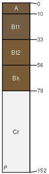
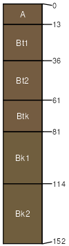
Xema
(45%)
Sandy (Sy) 15-19 Northern Plains Precipitation Zone
Aridic Haplustalfs
Well drained
Hydric: No
PAWS: 11 cm
hills / Shoulder
hills / Backslope
ridges / Summit
ridges / Shoulder
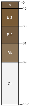
Mittenbutte
(25%)
Shallow Sandy (SwSy) 15-19 Northern Plains Precipitation Zone
Aridic Ustorthents
Well drained
Hydric: No
PAWS: 6 cm
ridges / Summit
ridges / Shoulder
hills / Summit
hills / Shoulder
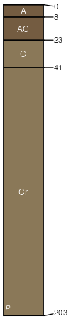
Rock outcrop
(15%)
Hydric: No
PAWS: NA
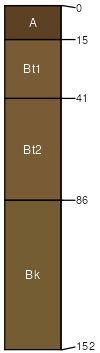
Vonalf
(5%)
Sandy (Sy) 15-19 Northern Plains Precipitation Zone
Aridic Haplustalfs
Well drained
Hydric: No
PAWS: 21 cm
ridges / Backslope
hills / Backslope
Elwop
(5%)
Sandy (Sy) 15-17 PZ
Aridic Haplustalfs
Well drained
Hydric: No
PAWS: 13 cm
hills / Summit
hills / Shoulder
ridges / Summit
ridges / Shoulder
Arwite
(5%)
Sandy (Sy) 15-17 PZ
Aridic Haplustalfs
Well drained
Hydric: No
PAWS: 22 cm
ridges / Backslope
ridges / Footslope
hills / Backslope
hills / Footslope
SSA
Scale
Published
Export
wy719
1:24,000
2013
2025-09-04