Uwharrie-Tatum complex, 8 to 15 percent slopes
Uwharrie
(75%)
Acidic upland forest, moist
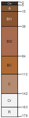
Typic Hapludults
Well drained
Hydric: No
PAWS: 33 cm
ridges / Backslope
hillslopes
Tatum
(15%)
Acidic upland forest, moist
Typic Hapludults
Well drained
Hydric: No
PAWS: 16 cm
ridges / Backslope
hillslopes
SSA
Scale
Published
Export
nc045
1:24,000
2000
2025-09-02