| Tatum gravelly loam, 6 to 15 percent slopes | TnD | 9146 | 328553 | c0wh | al021 | 1967 | 1:20000 |
Tatum gravelly loam, 2 to 6 percent slopes | TnB | 3560 | 328552 | c0wg | al021 | 1967 | 1:20000 |
Tatum-Chewacla association, hilly | TCD | 61987 | 122794 | 43s3 | al027 | 1971 | 1:20000 |
Tatum-Tallapoosa-Riverview association, steep | TRE | 52653 | 122795 | 43s4 | al027 | 1971 | 1:20000 |
Tatum-Fruithurst association, hilly | TFH | 97653 | 122810 | 43sm | al029 | 1974 | 1:24000 |
Tatum-Tallapoosa-Fruithurst association, steep | TTS | 86144 | 122811 | 43sn | al029 | 1974 | 1:24000 |
Tatum-Fruithurst complex, 6 to 10 percent slopes | TfC | 24908 | 122812 | 43sp | al029 | 1974 | 1:24000 |
Badin-Tatum-Tallapoosa complex, 2 to 6 percent slopes, moderately eroded | BdB2 | 1604 | 1895710 | 21mmy | al037 | 2006 | 1:24000 |
Tatum silt loam, 4 to 12 percent slopes | TaD | 4600 | 331459 | c3x7 | al117 | 1982 | 1:24000 |
Tatum-Weogufka association, steep | TWS | 3720 | 331458 | c3x6 | al117 | 1982 | 1:24000 |
Tallapoosa-Tatum association, hilly | ThE | 92030 | 523261 | kkhd | al121 | 1969 | 1:20000 |
Tallapoosa-Tatum complex, 6 to 15 percent slopes | TcD | 18057 | 523260 | kkhc | al121 | 1969 | 1:20000 |
Tatum slaty loam, 6 to 10 percent slopes | TmC | 7194 | 523263 | kkhg | al121 | 1969 | 1:20000 |
Tatum slaty loam, 2 to 6 percent slopes | TmB | 2401 | 523262 | kkhf | al121 | 1969 | 1:20000 |
Townley-Tatum complex, 6 to 10 percent slopes, eroded | TtC2 | 1373 | 523268 | kkhm | al121 | 1969 | 1:20000 |
Badin-Tatum-Tallapoosa complex, 2 to 6 percent slopes, moderately eroded | BdB2 | 2905 | 1476396 | 1lk9p | al123 | 2005 | 1:24000 |
Tatum-Montonia complex, 15 to 30 percent slopes | TaD | 1390 | 117098 | 3xvc | nc045 | 2000 | 1:24000 |
Uwharrie-Tatum complex, 8 to 15 percent slopes | UvC | 1206 | 117103 | 3xvj | nc045 | 2000 | 1:24000 |
Tatum-Montonia complex, 8 to 15 percent slopes | TaC | 751 | 117097 | 3xvb | nc045 | 2000 | 1:24000 |
Uwharrie-Tatum complex, 8 to 15 percent slopes, moderately eroded | UwC2 | 395 | 117104 | 3xvk | nc045 | 2000 | 1:24000 |
Tatum-Montonia complex, 2 to 8 percent slopes | TaB | 380 | 117096 | 3xv9 | nc045 | 2000 | 1:24000 |
Tatum gravelly silt loam, 15 to 25 percent slopes | TaE | 2161 | 112341 | 3rwx | nc063 | 1971 | 1:15840 |
Tatum loam, 10 to 15 percent slopes | TaD | 3260 | 112610 | 3s5l | nc069 | 1997 | 1:24000 |
Tatum loam, 15 to 30 percent slopes | TaE | 697 | 112611 | 3s5m | nc069 | 1997 | 1:24000 |
Tatum gravelly loam, 2 to 8 percent slopes | TaB | 13620 | 112656 | 3s72 | nc071 | 1985 | 1:24000 |
Tatum gravelly loam, 8 to 15 percent slopes | TaD | 11000 | 112657 | 3s73 | nc071 | 1985 | 1:24000 |
Tatum gravelly loam, 15 to 25 percent slopes | TaE | 9071 | 112658 | 3s74 | nc071 | 1985 | 1:24000 |
Tatum loam, 10 to 25 percent slopes | TaE | 7972 | 112783 | 3sc5 | nc077 | 1993 | 1:24000 |
Tatum silty clay loam, 2 to 6 percent slopes, moderately eroded | TmB2 | 10786 | 113064 | 3sn7 | nc083 | 1995 | 1:24000 |
Tatum silt loam, 10 to 25 percent slopes | TbE | 3090 | 113063 | 3sn6 | nc083 | 1995 | 1:24000 |
Tatum silty clay loam, 6 to 10 percent slopes, moderately eroded | TmC2 | 2356 | 113065 | 3sn8 | nc083 | 1995 | 1:24000 |
Tatum silt loam, 15 to 30 percent slopes | TaE | 750 | 117687 | 3ygc | nc181 | 1977 | 1:20000 |
Tatum loam, 2 to 6 percent slopes | TmB | 2823 | 116449 | 3x5f | nc195 | 1980 | 1:24000 |
Tatum silty clay loam, 6 to 10 percent slopes, severely eroded | TaC3 | 6485 | 132150 | 4fhx | sc021 | 1960 | 1:20000 |
Tatum very fine sandy loam, 2 to 6 percent slopes, eroded | TmB2 | 6484 | 132154 | 4fj1 | sc021 | 1960 | 1:20000 |
Tatum very fine sandy loam, 15 to 25 percent slopes | TmE | 6220 | 132159 | 4fj6 | sc021 | 1960 | 1:20000 |
Tatum silty clay loam, 10 to 15 percent slopes, severely eroded | TaD3 | 5978 | 132151 | 4fhy | sc021 | 1960 | 1:20000 |
Tatum silty clay loam, 15 to 35 percent slopes, severely eroded | TaF3 | 5599 | 132152 | 4fhz | sc021 | 1960 | 1:20000 |
Tatum very fine sandy loam, 6 to 10 percent slopes, eroded | TmC2 | 5517 | 132156 | 4fj3 | sc021 | 1960 | 1:20000 |
Tatum very fine sandy loam, 15 to 25 percent slopes, eroded | TmE2 | 5072 | 132160 | 4fj7 | sc021 | 1960 | 1:20000 |
Tatum very fine sandy loam, 25 to 35 percent slopes | TmF | 3730 | 132161 | 4fj8 | sc021 | 1960 | 1:20000 |
Tatum very fine sandy loam, 10 to 15 percent slopes, eroded | TmD2 | 2725 | 132158 | 4fj5 | sc021 | 1960 | 1:20000 |
Tatum silty clay loam, 2 to 6 percent slopes, severely eroded | TaB3 | 1837 | 132149 | 4fhw | sc021 | 1960 | 1:20000 |
Stony land | St | 1076 | 132148 | 4fhv | sc021 | 1960 | 1:20000 |
Tatum very fine sandy loam, 10 to 15 percent slopes | TmD | 994 | 132157 | 4fj4 | sc021 | 1960 | 1:20000 |
Tatum very fine sandy loam, 6 to 10 percent slopes | TmC | 721 | 132155 | 4fj2 | sc021 | 1960 | 1:20000 |
Tatum very fine sandy loam, 2 to 6 percent slopes | TmB | 595 | 132153 | 4fj0 | sc021 | 1960 | 1:20000 |
Tirzah silt loam, 15 to 25 percent slopes, eroded | TrE2 | 31 | 132165 | 4fjd | sc021 | 1960 | 1:20000 |
Tatum silt loam, 2 to 7 percent slopes | 23B | 21869 | 118292 | 3z2w | va011 | 1993 | 1:15840 |
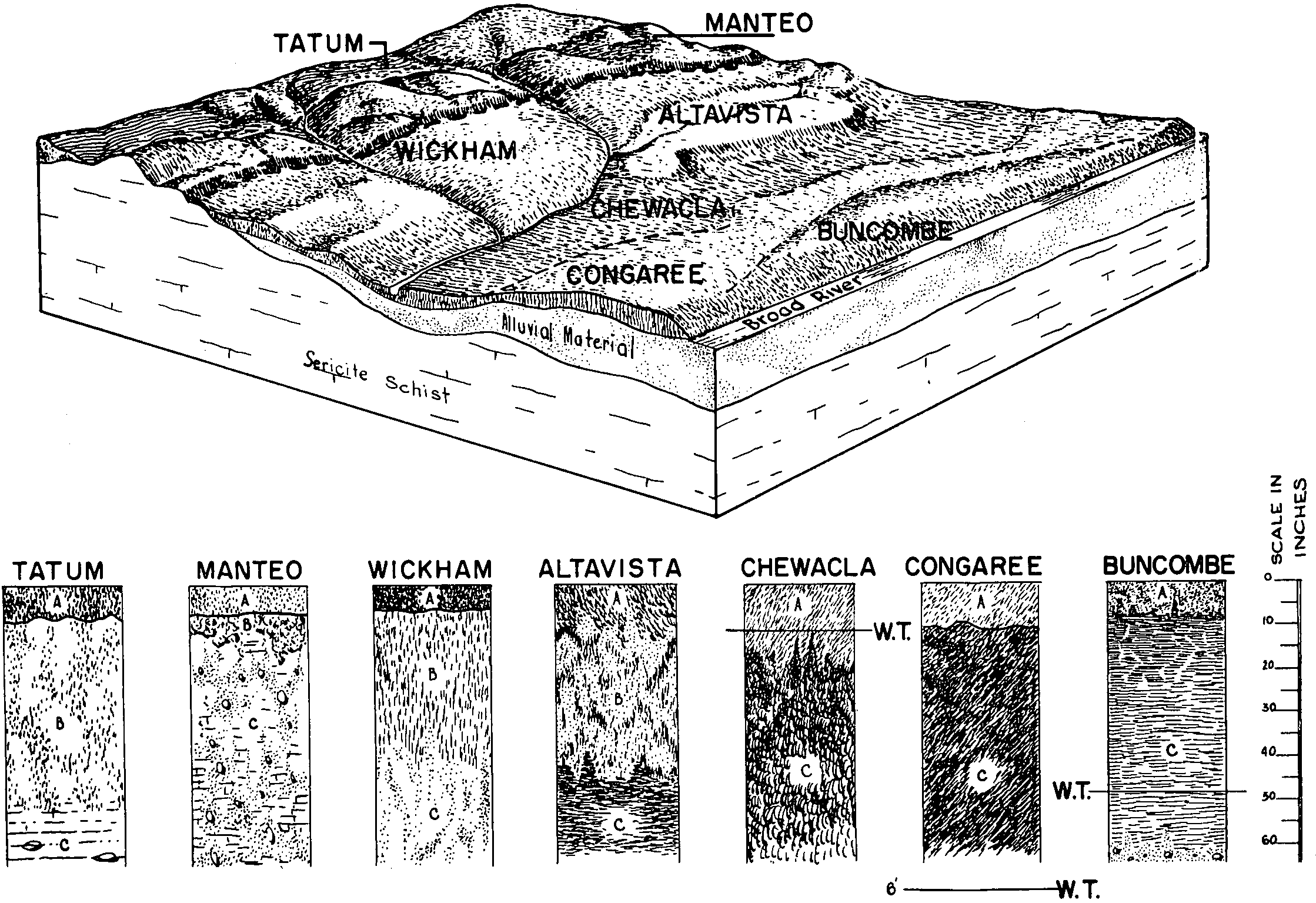
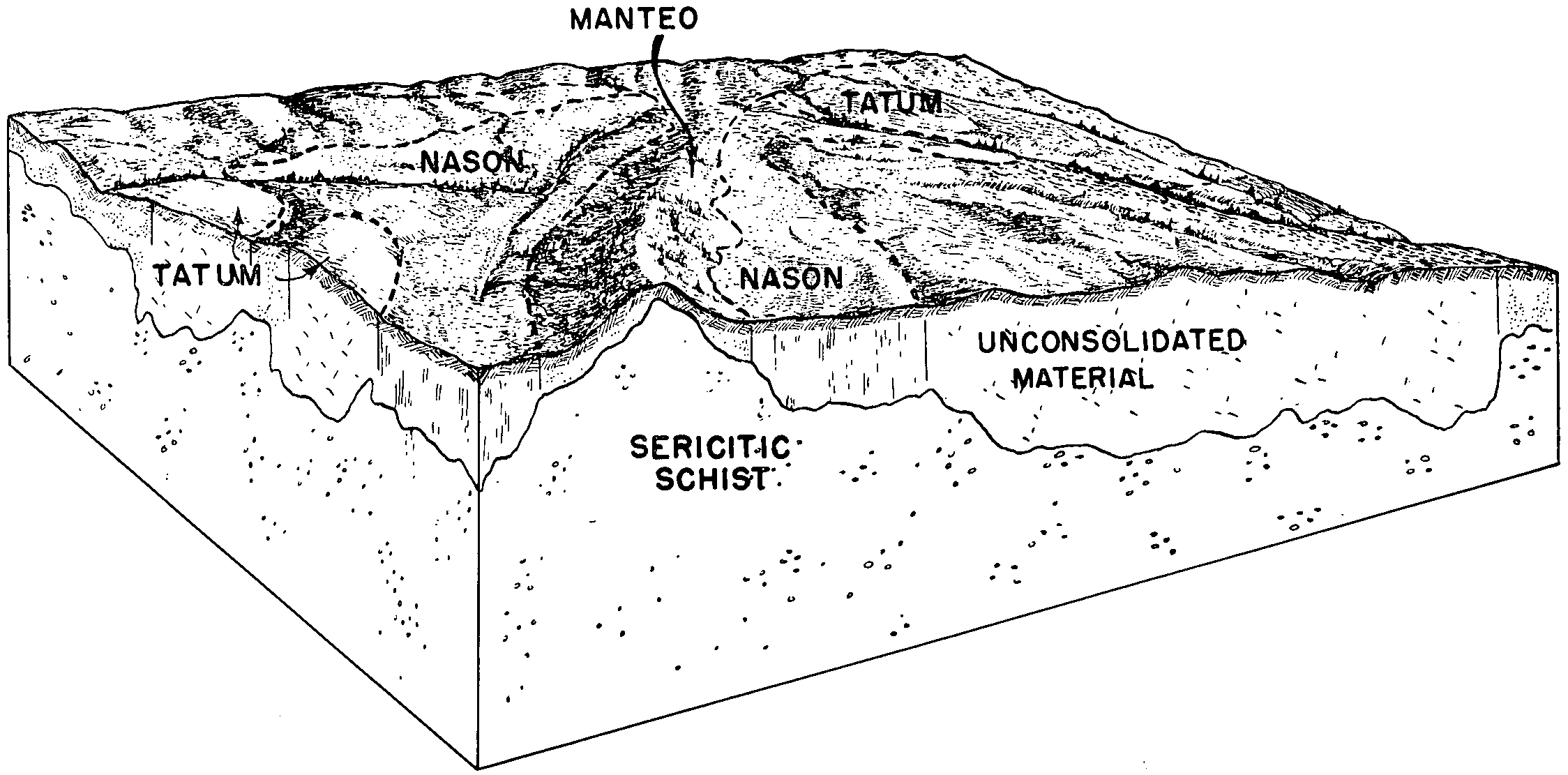
Tatum-Manteo complex, 7 to 15 percent slopes | 22C | 21375 | 118290 | 3z2t | va011 | 1993 | 1:15840 |
Tatum-Manteo complex, 15 to 25 percent slopes | 22D | 15230 | 118291 | 3z2v | va011 | 1993 | 1:15840 |
Tatum-Manteo complex, 2 to 7 percent slopes | 22B | 1256 | 118289 | 3z2s | va011 | 1993 | 1:15840 |
Turbeville-Tatum complex, 7 to 15 percent slopes | 25C | 686 | 118298 | 3z32 | va011 | 1993 | 1:15840 |
Turbeville-Tatum complex, 15 to 25 percent slopes | 25D | 551 | 118299 | 3z33 | va011 | 1993 | 1:15840 |
Turbeville-Tatum complex, 2 to 7 percent slopes | 25B | 517 | 118297 | 3z31 | va011 | 1993 | 1:15840 |
Tatum-Badin complex, 8 to 15 percent slopes | 27C | 1569 | 2420760 | 2m801 | va025 | 2007 | 1:24000 |
Tatum-Badin complex, 2 to 8 percent slopes | 27B | 520 | 2420759 | 2m800 | va025 | 2007 | 1:24000 |
Tatum silt loam, undulating phase | Tc | 24144 | 121839 | 42s9 | va065 | 1950 | 1:15840 |
Tatum silty clay loam, eroded undulating phase | Te | 2353 | 121840 | 42sb | va065 | 1950 | 1:15840 |
Tatum silty clay loam, eroded rolling phase | Td | 1697 | 121838 | 42s8 | va065 | 1950 | 1:15840 |
Tatum silt loam, rolling phase | Tb | 1629 | 121837 | 42s7 | va065 | 1950 | 1:15840 |
Tatum loam, undulating phase | Ta | 382 | 121836 | 42s6 | va065 | 1950 | 1:15840 |
Tatum loam, 7 to 15 percent slopes, eroded | 36C2 | 3990 | 119032 | 3zvr | va075 | 1976 | 1:15840 |
Tatum loam, 2 to 7 percent slopes, eroded | 36B2 | 3291 | 119031 | 3zvq | va075 | 1976 | 1:15840 |
Tatum loam, 15 to 25 percent slopes, eroded | 36D2 | 718 | 119033 | 3zvs | va075 | 1976 | 1:15840 |
Tatum silt loam, 2 to 7 percent slopes, eroded | TaB2 | 26874 | 119419 | 4087 | va109 | 1972 | 1:15840 |
Tatum silt loam, 7 to 15 percent slopes, eroded | TaC2 | 6677 | 119420 | 4088 | va109 | 1972 | 1:15840 |
Tatum silty clay loam, 7 to 15 percent slopes, severely eroded | TmC3 | 2680 | 119423 | 408c | va109 | 1972 | 1:15840 |
Tatum silty clay loam, 2 to 7 percent slopes, severely eroded | TmB3 | 818 | 119422 | 408b | va109 | 1972 | 1:15840 |
Tatum silt loam, 15 to 25 percent slopes, eroded | TaD2 | 211 | 119421 | 4089 | va109 | 1972 | 1:15840 |
Tatum silty clay loam, 15 to 25 percent slopes, severely eroded | TmD3 | 152 | 119424 | 408d | va109 | 1972 | 1:15840 |
Tatum loam, 15 to 30 percent slopes, eroded | 21D2 | 12261 | 119463 | 409n | va111 | 1979 | 1:20000 |
Tatum silt loam, 12 to 20 percent slopes | TaD | 7459 | 119615 | 40gk | va117 | 1990 | 1:24000 |
Tatum silty clay loam, 12 to 20 percent slopes, severely eroded | TcD | 850 | 119616 | 40gl | va117 | 1990 | 1:24000 |
Tatum loam, 7 to 15 percent slopes, eroded | 39C2 | 7383 | 120438 | 41b3 | va177 | 1980 | 1:15840 |
Tatum loam, 2 to 7 percent slopes | 39B | 4464 | 120437 | 41b2 | va177 | 1980 | 1:15840 |
Tatum loam, 15 to 25 percent slopes, eroded | 39D2 | 337 | 120439 | 41b4 | va177 | 1980 | 1:15840 |
Tatum loam, 6 to 15 percent slopes, eroded | TlC2 | 19226 | 120765 | 41nn | va631 | 1973 | 1:15840 |
Tatum loam, 15 to 25 percent slopes, eroded | TlE2 | 8842 | 120766 | 41np | va631 | 1973 | 1:15840 |
Tatum loam, 2 to 6 percent slopes | TlB | 7038 | 120764 | 41nm | va631 | 1973 | 1:15840 |
Tatum clay loam, 6 to 15 percent slopes, severely eroded | TmD3 | 911 | 120767 | 41nq | va631 | 1973 | 1:15840 |
Tatum clay loam, 15 to 25 percent slopes, severely eroded | TmE3 | 467 | 120768 | 41nr | va631 | 1973 | 1:15840 |