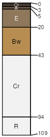
Goldston-Badin complex, 2 to 8 percent slopes
Goldston
(45%)
Acidic high hills and isolated ridges, depth restriction, dry
Typic Dystrudepts
Well drained
Hydric: No
PAWS: 4 cm
interfluves / Summit
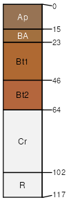
Badin
(40%)
Acidic Upland Forest, Depth Restriction, Dry-moist
Typic Hapludults
Well drained
Hydric: No
PAWS: 12 cm
ridges / Backslope
hillslopes
SSA
Scale
Published
Export
nc179
1:24,000
1991
2025-08-27