Rion-Wateree-Wedowee complex, 8 to 15 percent slopes
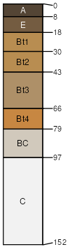
Rion
(35%)
Acidic upland forest, moist
Typic Hapludults
Well drained
Hydric: No
PAWS: 21 cm
hillslopes
ridges / Backslope
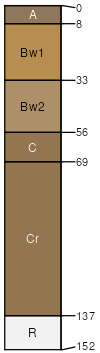
Wateree
(30%)
Lower piedmont acidic upland woodland, depth restriction, dry
Typic Dystrudepts
Well drained
Hydric: No
PAWS: 9 cm
hillslopes
ridges / Backslope
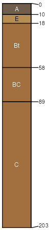
Wedowee
(20%)
Acidic upland forest, moist
Typic Kanhapludults
Well drained
Hydric: No
PAWS: 27 cm
hillslopes
ridges / Backslope
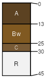
Wake
(5%)
Lithic Dystrudepts
Excessively drained
Hydric: No
PAWS: 2 cm
hillslopes
ridges / Backslope
Rock outcrop
(1%)
Hydric: No
PAWS: 0 cm
SSA
Scale
Published
Export
nc069
1:24,000
1997
2025-09-02