Eram-Verdigris complex, 0 to 12 percent slopes
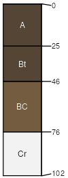
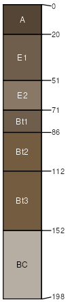
Eram
(55%)
Clayey Upland
Aquic Argiudolls
Moderately well drained
Hydric: No
PAWS: 16 cm
hillslopes / Backslope
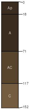
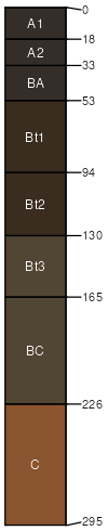
Verdigris
(30%)
Loamy Upland Drainageway
Cumulic Hapludolls
Well drained
Hydric: No
PAWS: 40 cm
drainageways
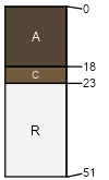
Collinsville
(5%)
Shallow Sandstone Upland
Lithic Hapludolls
Well drained
Hydric: No
PAWS: 6 cm
hillslopes / Backslope
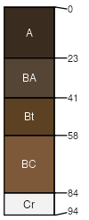
Bates
(5%)
Loamy Upland
Typic Argiudolls
Well drained
Hydric: No
PAWS: 13 cm
hillslopes / Backslope
Taloka
(3%)
Claypan Upland
Mollic Albaqualfs
Somewhat poorly drained
Hydric: No
PAWS: 31 cm
paleoterraces
Summit
(2%)
Loamy Upland
Oxyaquic Vertic Argiudolls
Somewhat poorly drained
Hydric: No
PAWS: 30 cm
interfluves / Backslope
interfluves / Footslope
SSA
Scale
Published
Export
ok131
1:24,000
1963
2025-08-29