Halyard-Fantail association, 30 to 85 percent slopes
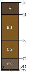
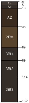
Halyard
(55%)
Moderately deep volcanic slopes 13-31 p.z.
Pachic Argixerolls
Moderately well drained
Hydric: No
PAWS: 11 cm
mountains
hills
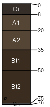
Fantail
(30%)
Loamy slopes 13-31 p.z.
Pachic Argixerolls
Well drained
Hydric: No
PAWS: 9 cm
hills
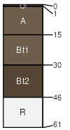
Rock outcrop
(5%)
Hydric: No
PAWS: NA
mountains
hills
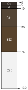
Topdeck
(3%)
Lithic Argixerolls
Hydric: No
PAWS: NA
mountains
hills
Tongva
(3%)
Pachic Argixerolls
Hydric: No
PAWS: NA
mountains
hills
Forestay
(2%)
Ultic Palexerolls
Hydric: No
PAWS: NA
mountains
hills / Shoulder
hills / Backslope
Typic Argixerolls
(2%)
Typic Argixerolls
Hydric: No
PAWS: NA
mountains
hills
SSA
Scale
Published
Export
ca688
1:24,000
2008
2025-09-08