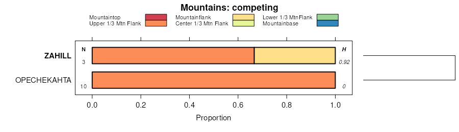
| Vida-Zahill loams, 2 to 8 percent slopes | 991C | 25069 | 1428511 | 2w28h | mt021 | 1971 | 1:24000 |
Zahill-Lambert complex, 15 to 65 percent slopes | Zm | 21770 | 342065 | cgyc | mt021 | 1971 | 1:24000 |
Zahill loam, 15 to 60 percent slopes | Zh | 17742 | 342064 | 2w28g | mt021 | 1971 | 1:24000 |
Zahill-Vida loams, 4 to 15 percent slopes | Vk | 12834 | 342060 | 2vyt4 | mt021 | 1971 | 1:24000 |
Vida-Zahill loams, 0 to 4 percent slopes | 991B | 9574 | 1428514 | 1jyh3 | mt021 | 1971 | 1:24000 |
Zahill-Zahl clay loams, 15 to 60 percent slopes | 72F | 36866 | 344044 | 2vyt5 | mt041 | 1994 | 1:24000 |
Zahill-Vida clay loams, 8 to 25 percent slopes | 721E | 10758 | 344040 | 2vyt6 | mt041 | 1994 | 1:24000 |
Zahill-Rock outcrop-Whitlash complex, 15 to 60 percent slopes | 899F | 10409 | 344099 | ck1z | mt041 | 1994 | 1:24000 |
Vida-Bearpaw-Zahill clay loams, 4 to 15 percent slopes | 671D | 10139 | 344026 | 2vyt1 | mt041 | 1994 | 1:24000 |
Vida-Zahill-Bearpaw clay loams, 2 to 8 percent slopes | 696C | 9143 | 344036 | cjzy | mt041 | 1994 | 1:24000 |
Zahill-Rock outcrop complex, 25 to 60 percent slopes | 725F | 5414 | 344042 | ck04 | mt041 | 1994 | 1:24000 |
Cabba-Zahill complex, 25 to 60 percent slopes | 204F | 2723 | 343871 | cjtm | mt041 | 1994 | 1:24000 |
Zahill-Vida clay loams, 8 to 25 percent slopes | 695E | 8897 | 344250 | 2vyt6 | mt051 | 1992 | 1:24000 |
Vida-Bearpaw-Zahill clay loams, 4 to 15 percent slopes | 692D | 7749 | 344247 | 2vyt1 | mt051 | 1992 | 1:24000 |
Zahill-Zahl clay loams, 15 to 60 percent slopes | 72F | 4319 | 344258 | 2vyt5 | mt051 | 1992 | 1:24000 |
Zahill-Cabba complex, 15 to 45 percent slopes | 723F | 3976 | 344257 | ck72 | mt051 | 1992 | 1:24000 |
Vida-Zahill clay loams, 2 to 8 percent slopes | 695C | 3342 | 344249 | ck6t | mt051 | 1992 | 1:24000 |
Vida-Williams, Zahill-high precipitation loams, 4 to 15 percent slopes | 691D | 1484 | 344246 | 2vyt0 | mt051 | 1992 | 1:24000 |
Vida-Zahill loams, 2 to 8 percent slopes | 151 | 107526 | 344351 | 2w28h | mt055 | 1981 | 1:24000 |
Zahill loam, 15 to 60 percent slopes | 170 | 28658 | 344372 | 2w28g | mt055 | 1981 | 1:24000 |
Zahill-Vida loams, 4 to 15 percent slopes | 169 | 25002 | 344370 | 2vyt4 | mt055 | 1981 | 1:24000 |
Zahill-Cabba loams, 8 to 15 percent slopes | 172 | 20800 | 344374 | ckbv | mt055 | 1981 | 1:24000 |
Zahill-Cabba loams, 15 to 45 percent slopes | 173 | 13624 | 344375 | ckbw | mt055 | 1981 | 1:24000 |
Zahill-Badland complex, 25 to 45 percent slopes | 171 | 9854 | 344373 | ckbt | mt055 | 1981 | 1:24000 |
Zahill-Yawdim complex, 15 to 45 percent slopes | 175 | 4467 | 344377 | ckby | mt055 | 1981 | 1:24000 |
Zahill-Yawdim complex, 4 to 15 percent slopes | 174 | 2583 | 344376 | ckbx | mt055 | 1981 | 1:24000 |
Vida-Zahill loams, 0 to 4 percent slopes | 187 | 1005 | 1485770 | 1lw22 | mt055 | 1981 | 1:24000 |
Zahill loam, 15 to 60 percent slopes | ZaF | 95952 | 345377 | 2w28g | mt083 | 1973 | 1:24000 |
Zahill-Lambert complex, 15 to 65 percent slopes | ZbF | 88550 | 345378 | cld7 | mt083 | 1973 | 1:24000 |
Zahill-Vida loams, 4 to 15 percent slopes | VhD | 55539 | 345374 | 2vyt4 | mt083 | 1973 | 1:24000 |
Vida-Zahill loams, 2 to 8 percent slopes | VhC | 46208 | 345373 | 2w28h | mt083 | 1973 | 1:24000 |
Vida-Zahill loams, 0 to 4 percent slopes | 991B | 430 | 1677536 | 1t9m2 | mt083 | 1973 | 1:24000 |
Vida-Zahill loams, 2 to 8 percent slopes | WzC | 172316 | 348881 | 2w28h | mt091 | 1971 | 1:24000 |
Zahill loam, 15 to 60 percent slopes | ZaE | 95250 | 348883 | 2w28g | mt091 | 1971 | 1:24000 |
Williams-Zahill loams, undulating | WzB | 87936 | 348880 | cq16 | mt091 | 1971 | 1:24000 |
Zahill-Williams complex, hilly | ZwE | 81626 | 348884 | cq1b | mt091 | 1971 | 1:24000 |
Lambert-Zahill complex, 20 to 50 percent slopes | LcF | 54233 | 348856 | cq0f | mt091 | 1971 | 1:24000 |
Zahill-Vida loams, 4 to 15 percent slopes | ZaD | 29149 | 348882 | 2vyt4 | mt091 | 1971 | 1:24000 |
Vida-Williams, Zahill-high precipitation loams, 4 to 15 percent slopes | 695D | 46822 | 345247 | 2vyt0 | mt101 | 1992 | 1:24000 |
Zahill-Zahl clay loams, 15 to 60 percent slopes | 721F | 15934 | 345257 | 2vyt5 | mt101 | 1992 | 1:24000 |
Zahill-Vida clay loams, 8 to 25 percent slopes | 696E | 15883 | 345248 | 2vyt6 | mt101 | 1992 | 1:24000 |
Zahill-Zahl complex, 15 to 25 percent slopes | 721E | 5744 | 345256 | cl89 | mt101 | 1992 | 1:24000 |
Zahill loam, 25 to 45 percent slopes | 72F | 3276 | 345259 | cl8d | mt101 | 1992 | 1:24000 |
Zahill-Dast-Cabba complex, 25 to 65 percent slopes | 722F | 815 | 345258 | cl8c | mt101 | 1992 | 1:24000 |
Vida-Williams, Zahill-high precipitation loams, 4 to 15 percent slopes | 695D | 28940 | 3111837 | 2vyt0 | mt600 | 1969 | 1:24000 |
Vida-Bearpaw-Zahill clay loams, 4 to 15 percent slopes | 692D | 497 | 3111827 | 2vyt1 | mt600 | 1969 | 1:24000 |
Zahill-Vida clay loams, 8 to 25 percent slopes | 151 | 59911 | 346331 | 2vyt6 | mt608 | 1976 | 1:24000 |
Zahill-Zahl clay loams, 15 to 60 percent slopes | 150 | 30074 | 346329 | 2vyt5 | mt608 | 1976 | 1:24000 |
Vida-Bearpaw-Zahill clay loams, 4 to 15 percent slopes | 136 | 22668 | 346300 | 2vyt1 | mt608 | 1976 | 1:24000 |
Cabba-Zahill association, steep | 24 | 11876 | 346390 | cmfw | mt608 | 1976 | 1:24000 |
Zahill-Zahl clay loams, 15 to 60 percent slopes | 72F | 24601 | 346901 | 2vyt5 | mt615 | 1992 | 1:24000 |
Zahill-Vida clay loams, 8 to 25 percent slopes | 721E | 23607 | 346898 | 2vyt6 | mt615 | 1992 | 1:24000 |
Vida-Bearpaw-Zahill clay loams, 4 to 15 percent slopes | 692D | 11009 | 346891 | 2vyt1 | mt615 | 1992 | 1:24000 |
Vida-Zahill clay loams, 2 to 8 percent slopes | 69C | 5837 | 346893 | cmz3 | mt615 | 1992 | 1:24000 |
Zahill-Sagedale-Wayden complex, 15 to 45 percent slopes | 722F | 5119 | 346899 | cmz9 | mt615 | 1992 | 1:24000 |
Zahill-Cabba complex, 15 to 45 percent slopes | 723F | 5009 | 346900 | cmzb | mt615 | 1992 | 1:24000 |
Vida-Williams, Zahill-high precipitation loams, 4 to 15 percent slopes | 691D | 2509 | 346890 | 2vyt0 | mt615 | 1992 | 1:24000 |
Vida-Zahill loams, 2 to 8 percent slopes | 70 | 479896 | 348278 | 2w28h | mt661 | 1982 | 1:24000 |
Zahill-Vida loams, 4 to 15 percent slopes | 71 | 148462 | 348279 | 2vyt4 | mt661 | 1982 | 1:24000 |
Zahill-Tinsley complex, 15 to 45 percent slopes | 76 | 73428 | 348284 | cpdz | mt661 | 1982 | 1:24000 |
Zahill loam, 15 to 60 percent slopes | 72 | 71029 | 348280 | 2w28g | mt661 | 1982 | 1:24000 |
Zahill-Cabba-Cambert complex, 15 to 45 percent slopes | 74 | 54440 | 348282 | cpdx | mt661 | 1982 | 1:24000 |
Zahill-Tinsley complex, 8 to 15 percent slopes | 75 | 20739 | 348283 | cpdy | mt661 | 1982 | 1:24000 |
Zahill-Cabba-Cambert complex, 8 to 15 percent slopes | 73 | 19251 | 348281 | cpdw | mt661 | 1982 | 1:24000 |
Zahl-Williams-Zahill complex, 6 to 9 percent slopes | C135C | 51502 | 2564088 | 2w42f | nd013 | 1991 | 1:24000 |
Williams-Zahl-Zahill complex, 6 to 9 percent slopes | C132C | 22 | 2595620 | 2w42j | nd013 | 1991 | 1:24000 |
Williams-Zahl-Zahill complex, 6 to 9 percent slopes | C132C | 96346 | 2564099 | 2w42j | nd015 | 1967 | 1:20000 |
Williams-Zahl-Zahill complex, 6 to 9 percent slopes | C132C | 14290 | 2564199 | 2w42j | nd021 | 1989 | 1:20000 |
Zahl-Williams-Zahill complex, 6 to 9 percent slopes | C135C | 6724 | 2595690 | 2w42f | nd021 | 1989 | 1:20000 |
Zahl-Williams-Zahill complex, 6 to 9 percent slopes | C135C | 112582 | 2564282 | 2w42f | nd023 | 1992 | 1:24000 |
Zahl-Dooley-Zahill complex, 6 to 9 percent slopes | C385C | 618 | 2564240 | 2q2jd | nd023 | 1992 | 1:24000 |
Williams-Zahl-Zahill complex, 6 to 9 percent slopes | C132C | 6 | 2595765 | 2w42j | nd023 | 1992 | 1:24000 |
Williams-Zahl-Zahill complex, 6 to 9 percent slopes | C132C | 25207 | 2564291 | 2w42j | nd029 | 1979 | 1:20000 |
Zahl-Williams-Zahill complex, 6 to 9 percent slopes | C135C | 91 | 2595824 | 2w42f | nd029 | 1979 | 1:20000 |
Livona-Zahl-Zahill complex, 6 to 9 percent slopes | C368C | 2 | 2596922 | 2q2kj | nd029 | 1979 | 1:20000 |
Williams-Zahl-Zahill complex, 6 to 9 percent slopes | C132C | 1004 | 2564372 | 2w42j | nd031 | 1990 | 1:20000 |
Williams-Zahl-Zahill complex, 6 to 9 percent slopes | C132C | 46618 | 2564387 | 2w42j | nd043 | 1985 | 1:20000 |
Zahl-Williams-Zahill complex, 6 to 9 percent slopes | C135C | 15203 | 2596677 | 2w42f | nd043 | 1985 | 1:20000 |
Livona-Zahl-Zahill complex, 6 to 9 percent slopes | C368C | 8062 | 2596947 | 2q2kj | nd043 | 1985 | 1:20000 |
Zahl-Williams-Zahill complex, 6 to 9 percent slopes | C135C | 9401 | 2566466 | 2w42f | nd045 | 1966 | 1:20000 |
Williams-Zahl-Zahill complex, 6 to 9 percent slopes | C132C | 4200 | 2566434 | 2w42j | nd045 | 1966 | 1:20000 |
Zahl-Williams-Zahill complex, 6 to 9 percent slopes | C135C | 93305 | 2566533 | 2w42f | nd047 | 1992 | 1:20000 |
Livona-Zahl-Zahill complex, 6 to 9 percent slopes | C368C | 181 | 2596967 | 2q2kj | nd047 | 1992 | 1:20000 |
Williams-Zahl-Zahill complex, 6 to 9 percent slopes | C132C | 75 | 2596696 | 2w42j | nd047 | 1992 | 1:20000 |
Williams-Zahl-Zahill complex, 6 to 9 percent slopes | C132C | 4123 | 2566545 | 2w42j | nd049 | 1987 | 1:20000 |
Zahl-Williams-Zahill complex, 6 to 9 percent slopes | C135C | 57943 | 2566619 | 2w42f | nd051 | 1992 | 1:24000 |
Williams-Zahl-Zahill complex, 6 to 9 percent slopes | C132C | 4332 | 2596727 | 2w42j | nd051 | 1992 | 1:24000 |
Vida-Zahill loams, 2 to 8 percent slopes | 43C | 325 | 351821 | 2w28h | nd053 | 2003 | 1:24000 |
Zahill loam, 15 to 60 percent slopes | 44E | 105 | 351825 | 2w28g | nd053 | 2003 | 1:24000 |
Zahill-Vida loams, 4 to 15 percent slopes | 44D | 88 | 351824 | 2vyt4 | nd053 | 2003 | 1:24000 |
Williams-Zahl-Zahill complex, 6 to 9 percent slopes | C132C | 109711 | 2566636 | 2w42j | nd055 | 1974 | 1:20000 |
Zahl-Williams-Zahill complex, 6 to 9 percent slopes | C135C | 10185 | 2566719 | 2w42f | nd055 | 1974 | 1:20000 |
Williams-Zahl-Zahill complex, 6 to 9 percent slopes | C132C | 99634 | 2566733 | 2w42j | nd061 | 1988 | 1:24000 |
Zahl-Williams-Zahill complex, 6 to 9 percent slopes | C135C | 1660 | 2567106 | 2w42f | nd061 | 1988 | 1:24000 |
Williams-Zahl-Zahill complex, 6 to 9 percent slopes | C132C | 88995 | 2566782 | 2w42j | nd083 | 1990 | 1:20000 |
Zahl-Williams-Zahill complex, 6 to 9 percent slopes | C135C | 27 | 2567189 | 2w42f | nd083 | 1990 | 1:20000 |
Williams-Zahl-Zahill complex, 6 to 9 percent slopes | C132C | 85438 | 2566829 | 2w42j | nd093 | 1990 | 1:24000 |
Zahl-Williams-Zahill complex, 6 to 9 percent slopes | C135C | 19619 | 2595739 | 2w42f | nd093 | 1990 | 1:24000 |
Livona-Zahl-Zahill complex, 6 to 9 percent slopes | C368C | 2194 | 2597028 | 2q2kj | nd093 | 1990 | 1:24000 |
Williams-Zahl-Zahill complex, 6 to 9 percent slopes | C132C | 103766 | 2566885 | 2w42j | nd101 | 1967 | 1:20000 |
Zahl-Williams-Zahill complex, 6 to 9 percent slopes | C135C | 4875 | 2566938 | 2w42f | nd101 | 1967 | 1:20000 |
Williams-Zahl-Zahill complex, 6 to 9 percent slopes | C132C | 23224 | 2566950 | 2w42j | nd103 | 1966 | 1:12000 |
Zahl-Williams-Zahill complex, 6 to 9 percent slopes | C135C | 20592 | 2566976 | 2w42f | nd103 | 1966 | 1:12000 |
Vida-Zahill loams, 2 to 8 percent slopes | 2032 | 108546 | 339038 | 2w28h | nd105 | 1993 | 1:24000 |
Williams-Zahl-Zahill complex, 6 to 9 percent slopes | C132C | 58239 | 2566992 | 2w42j | nd105 | 1993 | 1:24000 |
Zahl-Williams-Zahill complex, 6 to 9 percent slopes | C135C | 48270 | 2596789 | 2w42f | nd105 | 1993 | 1:24000 |
Zahill-Vida loams, 4 to 15 percent slopes | W2081 | 30137 | 339039 | 2vyt4 | nd105 | 1993 | 1:24000 |
Zahill loam, 15 to 60 percent slopes | W2176 | 29025 | 339045 | 2w28g | nd105 | 1993 | 1:24000 |
Livona-Zahl-Zahill complex, 6 to 9 percent slopes | C368C | 1733 | 2567001 | 2q2kj | nd105 | 1993 | 1:24000 |
Williams-Zahl-Zahill complex, 6 to 9 percent slopes | C132C | 3234 | 2765557 | 2w42j | sd013 | 1987 | 1:20000 |
Zahl-Williams-Zahill complex, 6 to 9 percent slopes | C175C | 1307 | 2765579 | 2w42f | sd013 | 1987 | 1:20000 |
Williams-Zahl-Zahill complex, 6 to 9 percent slopes | C212C | 35496 | 2797923 | 2w42j | sd021 | 1978 | 1:20000 |
Zahl-Williams-Zahill complex, 6 to 9 percent slopes | C175C | 24055 | 2797902 | 2w42f | sd021 | 1978 | 1:20000 |
Zahl-Williams-Zahill complex, 6 to 9 percent slopes | C175C | 30456 | 2798575 | 2w42f | sd045 | 1973 | 1:20000 |
Williams-Zahl-Zahill complex, 6 to 9 percent slopes | C212C | 149 | 2798598 | 2w42j | sd045 | 1973 | 1:20000 |
Williams-Zahill-Bowbells complex, 3 to 15 percent slopes | C173D | 16 | 2798595 | 2rrql | sd045 | 1973 | 1:20000 |
Williams-Zahill-Bowbells loams, 2 to 15 percent slopes | WzD | 6387 | 355211 | cxmf | sd049 | 1981 | 1:20000 |
Williams-Zahill-Bowbells complex, 3 to 15 percent slopes | C173D | 6017 | 2798666 | 2rrql | sd049 | 1981 | 1:20000 |
Zahl-Williams-Zahill complex, 6 to 9 percent slopes | C135C | 2475 | 2798645 | 2w42f | sd049 | 1981 | 1:20000 |
Zahill-Straw complex, 2 to 25 percent slopes | C139E | 2398 | 2798659 | 2rrpv | sd049 | 1981 | 1:20000 |
Zahill loam, 15 to 40 percent slopes | ZaE | 2221 | 355213 | cxmh | sd049 | 1981 | 1:20000 |
Zahill-La Prairie complex, 2 to 25 percent slopes | ZlD | 1922 | 355215 | cxmk | sd049 | 1981 | 1:20000 |
Zahl-Zahill complex, 15 to 40 percent slopes | C133F | 1584 | 2798657 | 2rrpr | sd049 | 1981 | 1:20000 |
Zahl-Zahill complex, 6 to 25 percent slopes, very stony | C134E | 1282 | 2798658 | 2rrpt | sd049 | 1981 | 1:20000 |
Zahill very stony loam, 6 to 25 percent slopes | ZcE | 671 | 355214 | cxmj | sd049 | 1981 | 1:20000 |
Zahl-Williams-Zahill complex, 6 to 9 percent slopes | C175C | 15550 | 2798737 | 2w42f | sd089 | 1980 | 1:20000 |
Williams-Zahl-Zahill complex, 6 to 9 percent slopes | C212C | 44 | 2798768 | 2w42j | sd089 | 1980 | 1:20000 |
Zahl-Williams-Zahill complex, 6 to 9 percent slopes | C135C | 4950 | 2799467 | 2w42f | sd107 | 1983 | 1:20000 |
Williams-Zahl-Zahill complex, 6 to 9 percent slopes | C212C | 77 | 2799480 | 2w42j | sd107 | 1983 | 1:20000 |
Williams-Zahill-Bowbells complex, 3 to 15 percent slopes | C173D | 58 | 2799478 | 2rrql | sd107 | 1983 | 1:20000 |
Zahl-Williams-Zahill complex, 6 to 9 percent slopes | C135C | 673 | 2799504 | 2w42f | sd115 | 1997 | 1:24000 |
Williams-Zahl-Zahill complex, 6 to 9 percent slopes | C132C | 257 | 2799487 | 2w42j | sd115 | 1997 | 1:24000 |
Zahl-Zahill complex, 15 to 40 percent slopes | C133F | 128 | 2799510 | 2rrpr | sd115 | 1997 | 1:24000 |
Williams-Zahl-Zahill complex, 6 to 9 percent slopes | C212C | 16206 | 2800125 | 2w42j | sd129 | 1975 | 1:20000 |
Zahl-Williams-Zahill complex, 6 to 9 percent slopes | C175C | 6481 | 2800108 | 2w42f | sd129 | 1975 | 1:20000 |
Zahill-Shaboom families, complex, 3 to 25 percent slopes | 80 | 1354 | 815233 | wc9v | ut651 | | 1:24000 |
Zahill family very cobbly clay loam, 10 to 25 percent slopes | 97 | 956 | 708432 | rs5n | wy632 | | 1:24000 |
Zahill family very cobbly loam, 0 to 10 percent slopes | 96 | 789 | 708428 | rs5j | wy632 | | 1:24000 |
