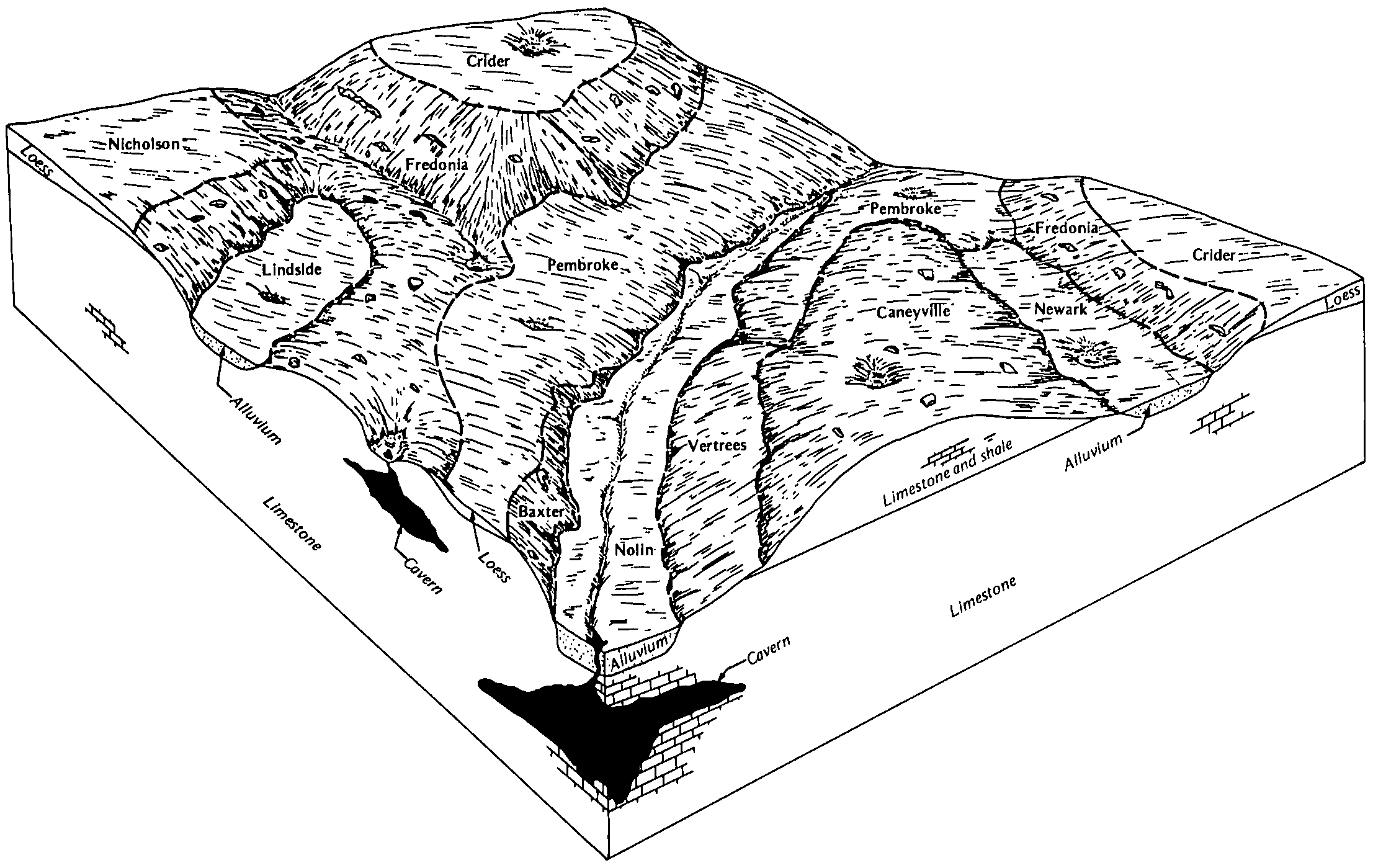
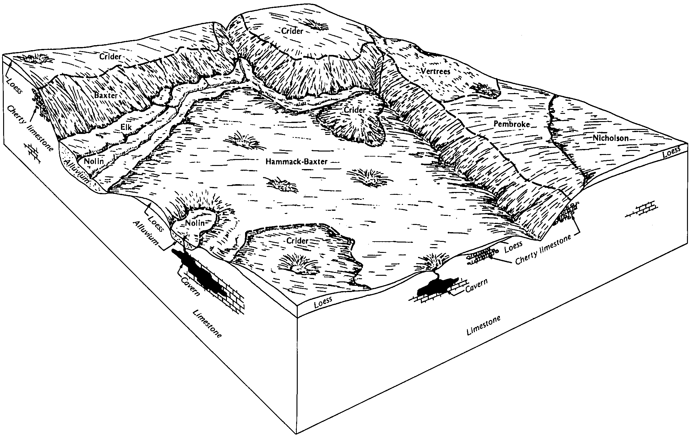
| Vertrees-Haggatt-Caneyville complex, karst, hilly, severely eroded | VccD3 | 37755 | 1678191 | 1tb96 | in061 | 2007 | 1:12000 |
Vertrees-Crider-Caneyville complex, karst, rolling, severely eroded | VcaC3 | 31891 | 780677 | v6c4 | in061 | 2007 | 1:12000 |
Vertrees-Crider-Caneyville silt loams, karst, hilly, eroded | VcbD2 | 18074 | 1677573 | 1t9n8 | in061 | 2007 | 1:12000 |
Crider-Vertrees silt loams, karst, rolling, eroded | CteC2 | 15465 | 780674 | v6c1 | in061 | 2007 | 1:12000 |
Urban land-Crider-Vertrees complex, karst, rolling | UflC | 2426 | 1686618 | 1tm21 | in061 | 2007 | 1:12000 |
Vertrees silt loam, 12 to 20 percent slopes | VeD | 1527 | 1727512 | 1vzm6 | ky011 | 2006 | 1:12000 |
Vertrees silt loam, 6 to 12 percent slopes | VeC | 579 | 1727511 | 1vzm5 | ky011 | 2006 | 1:12000 |
Fredonia-Vertrees complex, 12 to 20 percent slopes, eroded, rocky | FvD2 | 839 | 1404752 | 1j4rl | ky033 | 2005 | 1:12000 |
Vertrees silty clay loam, 6 to 12 percent slopes | VeC | 12871 | 549084 | lfcd | ky047 | 1977 | 1:20000 |
Vertrees silt loam, 6 to 12 percent slopes | VrC | 2480 | 549816 | lg40 | ky213 | 1982 | 1:20000 |
Vertrees silt loam, 2 to 6 percent slopes | VrB | 1410 | 549815 | lg3z | ky213 | 1982 | 1:20000 |
Fredonia-Vertrees complex, 2 to 6 percent slopes | FcB | 1070 | 549798 | lg3f | ky213 | 1982 | 1:20000 |
Vertrees silty clay loam, 6 to 12 percent slopes, severely eroded | VsC3 | 1050 | 549817 | lg41 | ky213 | 1982 | 1:20000 |
Vertrees silty clay loam, 6 to 12 percent slopes, eroded | VeC2 | 7100 | 551183 | lhk3 | ky219 | 1984 | 1:20000 |
Fredonia-Vertrees complex, 6 to 12 percent slopes, very rocky | FeC | 25248 | 553857 | llbc | ky227 | 2004 | 1:12000 |
Fredonia-Vertrees-Urban land complex, 2 to 6 percent slopes, rocky | FnB | 2712 | 553823 | ll98 | ky227 | 2004 | 1:12000 |
Fredonia-Vertrees-Urban land complex, 6 to 12 percent slopes, eroded, rocky | FnC2 | 2140 | 553824 | ll99 | ky227 | 2004 | 1:12000 |
Vertrees silty clay loam, 6 to 12 percent slopes, severely eroded | VrC3 | 1893 | 553841 | ll9v | ky227 | 2004 | 1:12000 |
Fredonia-Vertrees-Urban land complex, 6 to 12 percent slopes, very rocky | FnC | 607 | 553858 | llbd | ky227 | 2004 | 1:12000 |
Fredonia-Vertrees complex, 2 to 6 percent slopes, rocky | FeB | 286 | 553820 | ll95 | ky227 | 2004 | 1:12000 |
Vertrees-Urban land complex, 6 to 12 percent slopes, severely eroded | VtC3 | 193 | 553840 | ll9t | ky227 | 2004 | 1:12000 |
Vertrees silt loam, 6 to 12 percent slopes | VeC | 2063 | 551566 | lhyg | ky606 | 1979 | 1:20000 |
Caneyville-Vertrees silt loams, 12 to 20 percent slopes | CeD | 1499 | 551523 | lhx2 | ky606 | 1979 | 1:20000 |
Vertrees silty clay loam 6 to 20 percent slopes, severely eroded | VtD3 | 30260 | 551079 | 2zs5m | ky621 | 1975 | 1:20000 |
Vertrees silt loam, 6 to 12 percent slopes | VrC | 28575 | 551076 | 2zs5j | ky621 | 1975 | 1:20000 |
Vertrees silt loam, 12 to 20 percent slopes | VrD | 22565 | 551077 | 2zs5l | ky621 | 1975 | 1:20000 |
Vertrees silt loam, 20 to 30 percent slopes, very rocky | VrE | 5105 | 551078 | 2zs5n | ky621 | 1975 | 1:20000 |
Talbott cherty silty clay loam, 6 to 12 percent slopes, eroded (vertrees) | TbC2 | 18006 | 2453013 | 2nbkg | ky646 | 1966 | 1:15840 |
Talbott cherty silty clay loam, 12 to 20 percent slopes, eroded (vertrees) | TbD2 | 9149 | 2453014 | 2nbkh | ky646 | 1966 | 1:15840 |
Talbott cherty silty clay loam, 2 to 6 percent slopes, eroded (vertrees) | TbB2 | 3133 | 2453012 | 2nbkf | ky646 | 1966 | 1:15840 |
Talbott cherty silty clay, 6 to 12 percent slopes, severely eroded (vertrees) | TcC3 | 2537 | 2453015 | 2nbkj | ky646 | 1966 | 1:15840 |
Talbott silty clay loam, 2 to 6 percent slopes, eroded (vertrees) | TlB2 | 825 | 2453016 | 2nbkk | ky646 | 1966 | 1:15840 |
Talbott silty clay loam, 6 to 12 percent slopes, eroded (vertrees) | TlC2 | 528 | 2453017 | 2nbkl | ky646 | 1966 | 1:15840 |
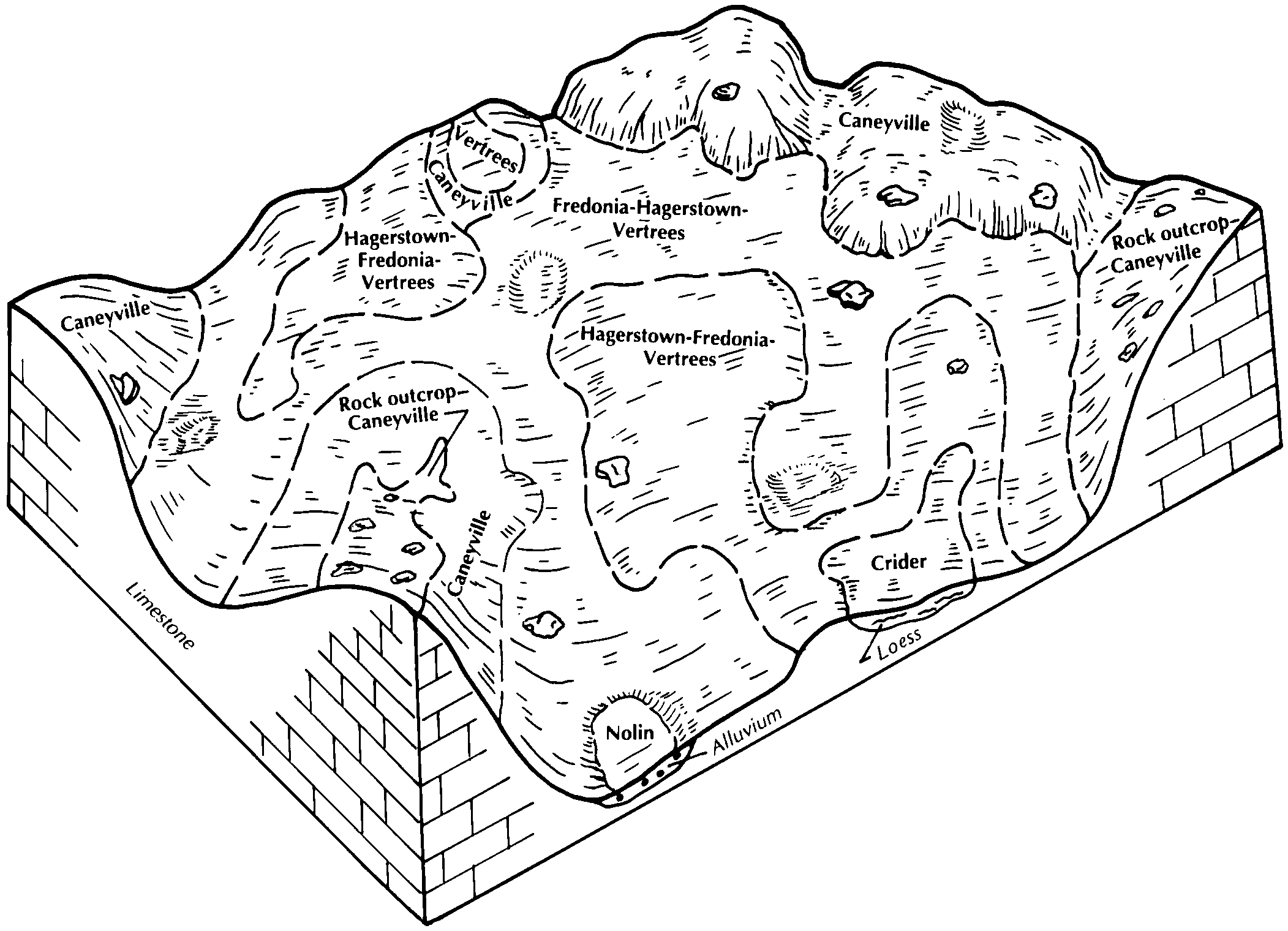
Fredonia-Hagerstown-Vertrees silt loams, rocky, 6 to 20 percent slopes | FdC | 12747 | 2453072 | 2nbmc | ky647 | 1989 | 1:20000 |
Vertrees silt loam, 6 to 12 percent slopes, eroded | VrC2 | 4172 | 2453109 | 2nbnk | ky647 | 1989 | 1:20000 |
Hagerstown-Fredonia-Vertrees silt loams, rocky, 2 to 6 percent slopes | HdB | 2459 | 2453076 | 2nbmh | ky647 | 1989 | 1:20000 |
Vertrees silt loam, 2 to 6 percent slopes, eroded | VrB2 | 1827 | 2453108 | 2nbnj | ky647 | 1989 | 1:20000 |
Vertrees silt loam, 12 to 20 percent slopes, eroded | VrD2 | 1125 | 2453110 | 2nbnl | ky647 | 1989 | 1:20000 |
Vertrees silty clay loam, 6 to 12 percent slopes, severely eroded | VtC3 | 961 | 2453112 | 2nbnn | ky647 | 1989 | 1:20000 |
Fredonia-Hagerstown-Vertrees complex, rocky, 6 to 20 percent slopes, severely eroded | FdC3 | 799 | 2453073 | 2nbmd | ky647 | 1989 | 1:20000 |
Vertrees silt loam, 20 to 30 percent slopes | VrE | 754 | 2453111 | 2nbnm | ky647 | 1989 | 1:20000 |
Fredonia-Hagerstown-Vertrees silt loams, 6 to 20 percent slopes, very rocky | FdC | 190 | 2379388 | 2kvyg | ky648 | 2009 | 1:12000 |
Vertrees silt loam, 6 to 12 percent slopes, eroded | VrC2 | 28 | 2379425 | 2kvzn | ky648 | 2009 | 1:12000 |
Frederick and Vertrees gravelly silt loams, 15 to 25 percent slopes | 13D | 4589 | 517077 | kc1x | va121 | 1980 | 1:15840 |
Frederick and Vertrees gravelly silt loams, 7 to 15 percent slopes | 13C | 3414 | 517076 | kc1w | va121 | 1980 | 1:15840 |
Frederick and Vertrees silt loams, 7 to 15 percent slopes | 12C | 1490 | 517074 | kc1t | va121 | 1980 | 1:15840 |
Frederick and Vertrees gravelly silt loams, 2 to 7 percent slopes | 13B | 1293 | 517075 | kc1v | va121 | 1980 | 1:15840 |
Frederick and Vertrees silt loams, 2 to 7 percent slopes | 12B | 647 | 517073 | kc1s | va121 | 1980 | 1:15840 |
Vertrees-Rock outcrop complex, 8 to 15 percent slopes | VtC | 2939 | 1710348 | 1vdrj | wv037 | | 1:24000 |
Vertrees silt loam, 3 to 8 percent slopes, very rocky | VrB | 1775 | 1710344 | 1vdrd | wv037 | | 1:24000 |
Vertrees silt loam, 3 to 8 percent slopes | VeB | 1642 | 1710342 | 1vdrb | wv037 | | 1:24000 |
Vertrees-Rock outcrop complex, 3 to 8 percent slopes | VtB | 1528 | 1710347 | 1vdrh | wv037 | | 1:24000 |
Vertrees silt loam, 8 to 15 percent slopes, very rocky | VrC | 771 | 1710345 | 1vdrf | wv037 | | 1:24000 |
Vertrees silt loam, 8 to 15 percent slopes | VeC | 239 | 1710343 | 1vdrc | wv037 | | 1:24000 |
Vertrees-Rock outcrop complex, 15 to 25 percent slopes | VtD | 159 | 1710349 | 1vdrk | wv037 | | 1:24000 |
Vertrees silty clay loam, 8 to 15 percent slopes, very rocky | VsC | 69 | 1710346 | 1vdrg | wv037 | | 1:24000 |


