| Macomber-Taconic complex, 3 to 15 percent slopes, very rocky | 401C | 1986 | 3395867 | 9lsc | ct601 | 2003 | 1:12000 |
Taconic-Rock outcrop complex, 45 to 70 percent slopes | 403F | 922 | 3395870 | 9lsg | ct601 | 2003 | 1:12000 |
Taconic-Rock outcrop complex, 15 to 45 percent slopes | 403E | 765 | 3395869 | 9lsf | ct601 | 2003 | 1:12000 |
Taconic-Macomber-Rock outcrop complex, 15 to 25 percent slopes | 402D | 416 | 3395868 | 9lsd | ct601 | 2003 | 1:12000 |
Taconic-Rock outcrop complex, 3 to 15 percent slopes | 403C | 139 | 3395893 | 9lt7 | ct601 | 2003 | 1:12000 |
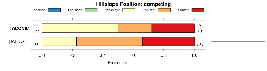
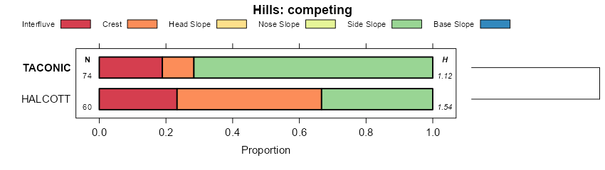
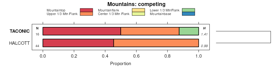
Taconic-Macomber association, steep, very stony | 932E | 36668 | 276653 | 98w9 | ma003 | 1984 | 1:25000 |
Taconic-Macomber association, rolling, very stony | 932C | 11956 | 276652 | 98w8 | ma003 | 1984 | 1:25000 |
Macomber-Taconic complex, 25 to 60 percent slopes, very rocky | 152F | 518 | 279007 | 9cb7 | ma011 | 2012 | 1:12000 |
Taconic-Macomber-Rock outcrop complex, 8 to 15 percent slopes | 153C | 397 | 279006 | 9cb6 | ma011 | 2012 | 1:12000 |
Macomber-Taconic complex, 15 to 25 percent slopes, very rocky | 152D | 296 | 279014 | 9cbg | ma011 | 2012 | 1:12000 |
Macomber-Taconic complex, 8 to 15 percent slopes, very rocky | 152C | 273 | 279015 | 9cbh | ma011 | 2012 | 1:12000 |
Macomber-Taconic complex, 3 to 8 percent slopes, very rocky | 152B | 180 | 279016 | 9cbj | ma011 | 2012 | 1:12000 |
Macomber-Taconic association, steep, very rocky | MbE | 21620 | 290361 | 9r4h | ny021 | 1985 | 1:15840 |
Taconic-Macomber association, very steep, very rocky | TmF | 10937 | 290293 | 9r29 | ny021 | 1985 | 1:15840 |
Macomber-Taconic association, strongly sloping, rocky | MaC | 8677 | 290360 | 9r4g | ny021 | 1985 | 1:15840 |
Taconic-Rock outcrop complex, very steep | TrF | 923 | 290724 | 9rj6 | ny027 | 1992 | 1:24000 |
Taconic-Rock outcrop complex, steep | TrE | 611 | 290723 | 9rj5 | ny027 | 1992 | 1:24000 |
Macomber-Taconic complex, rolling, very rocky | McC | 529 | 290695 | 9rh8 | ny027 | 1992 | 1:24000 |
Taconic-Macomber-Rock outcrop complex, hilly | TmD | 488 | 290722 | 9rj4 | ny027 | 1992 | 1:24000 |
Macomber-Taconic channery silt loams, very rocky, steep | MaE | 9589 | 293181 | 9v2g | ny083 | 1980 | 1:15840 |
Macomber-Taconic channery silt loams, very rocky, very steep | MaF | 6131 | 293182 | 9v2h | ny083 | 1980 | 1:15840 |
Macomber-Taconic channery silt loams, very rocky, sloping | MaC | 1494 | 293180 | 9v2f | ny083 | 1980 | 1:15840 |
Macomber-Taconic complex, 25 to 60 percent slopes, rocky | 42E | 15916 | 281493 | 9fxf | vt003 | 1992 | 1:20000 |
Macomber-Taconic complex, 15 to 25 percent slopes, rocky | 42D | 6783 | 281492 | 9fxd | vt003 | 1992 | 1:20000 |
Taconic-Macomber complex, 25 to 60 percent slopes, very rocky | 43E | 6768 | 281496 | 9fxj | vt003 | 1992 | 1:20000 |
Taconic-Macomber complex, 15 to 25 percent slopes, very rocky | 43D | 4199 | 281495 | 9fxh | vt003 | 1992 | 1:20000 |
Macomber-Taconic complex, 8 to 15 percent slopes, rocky | 42C | 3484 | 281491 | 9fxc | vt003 | 1992 | 1:20000 |
Taconic-Macomber complex, 8 to 15 percent slopes, very rocky | 43C | 1107 | 281494 | 9fxg | vt003 | 1992 | 1:20000 |
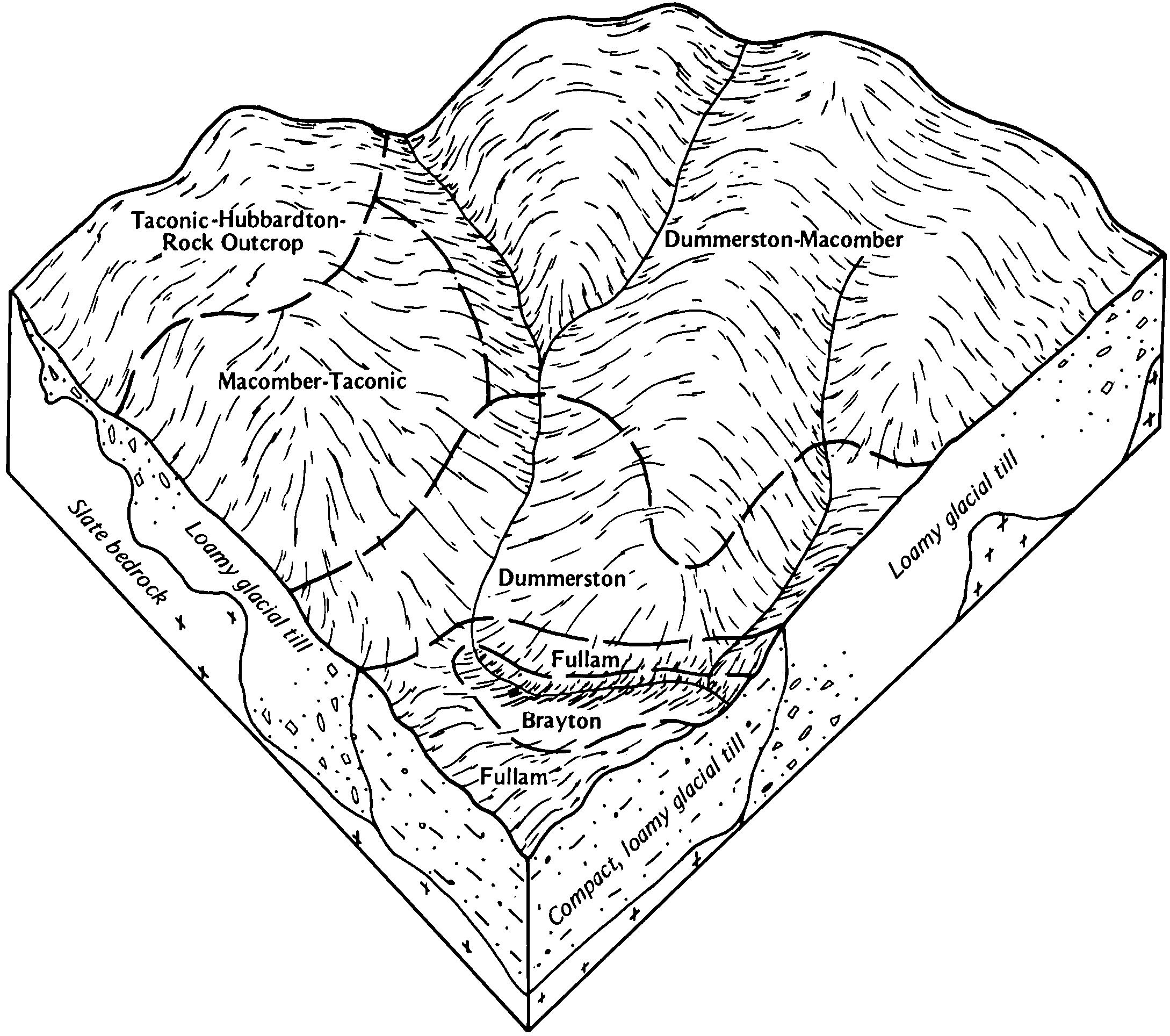
Taconic-Hubbardton-Rock outcrop complex, 25 to 70 percent slopes, very stony | 11F | 825 | 281395 | 9ft8 | vt003 | 1992 | 1:20000 |
Taconic-Hubbardton-Macomber complex, 25 to 80 percent slopes, very rocky | 12F | 40309 | 282154 | 9glr | vt021 | 1985 | 1:20000 |
Taconic-Macomber complex, 8 to 25 percent slopes, very rocky | 43C | 25218 | 282336 | 9gsm | vt021 | 1985 | 1:20000 |
Macomber-Taconic complex, 25 to 80 percent slopes, rocky | 42F | 18279 | 282334 | 9gsk | vt021 | 1985 | 1:20000 |
Macomber-Taconic complex, 15 to 25 percent slopes, rocky | 42D | 16054 | 282332 | 9gsh | vt021 | 1985 | 1:20000 |
Taconic-Hubbardton complex, 8 to 25 percent slopes, very rocky | 11C | 15460 | 282126 | 9gkv | vt021 | 1985 | 1:20000 |
Macomber-Taconic complex, 8 to 15 percent slopes, rocky | 42C | 14250 | 282331 | 9gsg | vt021 | 1985 | 1:20000 |
Taconic-Hubbardton-Rock outcrop complex, 60 to 80 percent slopes | 172F | 1335 | 282567 | 9h12 | vt023 | 1996 | 1:20000 |
Macomber-Taconic complex, 15 to 25 percent slopes, very rocky | 69D | 8620 | 282069 | 9gj0 | vt025 | 1984 | 1:20000 |
Macomber-Taconic complex, 8 to 15 percent slopes, very rocky | 69C | 6388 | 282068 | 9ghz | vt025 | 1984 | 1:20000 |
Macomber-Taconic complex, 25 to 70 percent slopes, very rocky | 69E | 5121 | 282070 | 9gj1 | vt025 | 1984 | 1:20000 |
Taconic-Hubbardton-Rock outcrop complex, 25 to 70 percent slopes | 68E | 3720 | 282067 | 9ghy | vt025 | 1984 | 1:20000 |
Taconic-Hubbardton-Rock outcrop complex, 8 to 25 percent slopes | 68D | 3475 | 282066 | 9ghx | vt025 | 1984 | 1:20000 |
Macomber-Taconic complex, 15 to 25 percent slopes, very rocky | 80D | 1433 | 283314 | 9ht5 | vt027 | 2000 | 1:20000 |
Macomber-Taconic complex, 8 to 15 percent slopes, very rocky | 80C | 606 | 283313 | 9ht4 | vt027 | 2000 | 1:20000 |
Macomber-Taconic complex, 25 to 70 percent slopes, very rocky | 80F | 536 | 283315 | 9ht6 | vt027 | 2000 | 1:20000 |
Taconic-Hubbardton-Rock outcrop complex, 25 to 70 percent slopes | 81F | 47 | 283316 | 9ht7 | vt027 | 2000 | 1:20000 |
Taconic-Hubbardton-Rock outcrop complex, 8 to 25 percent slopes | 81D | 15 | 283317 | 9ht8 | vt027 | 2000 | 1:20000 |