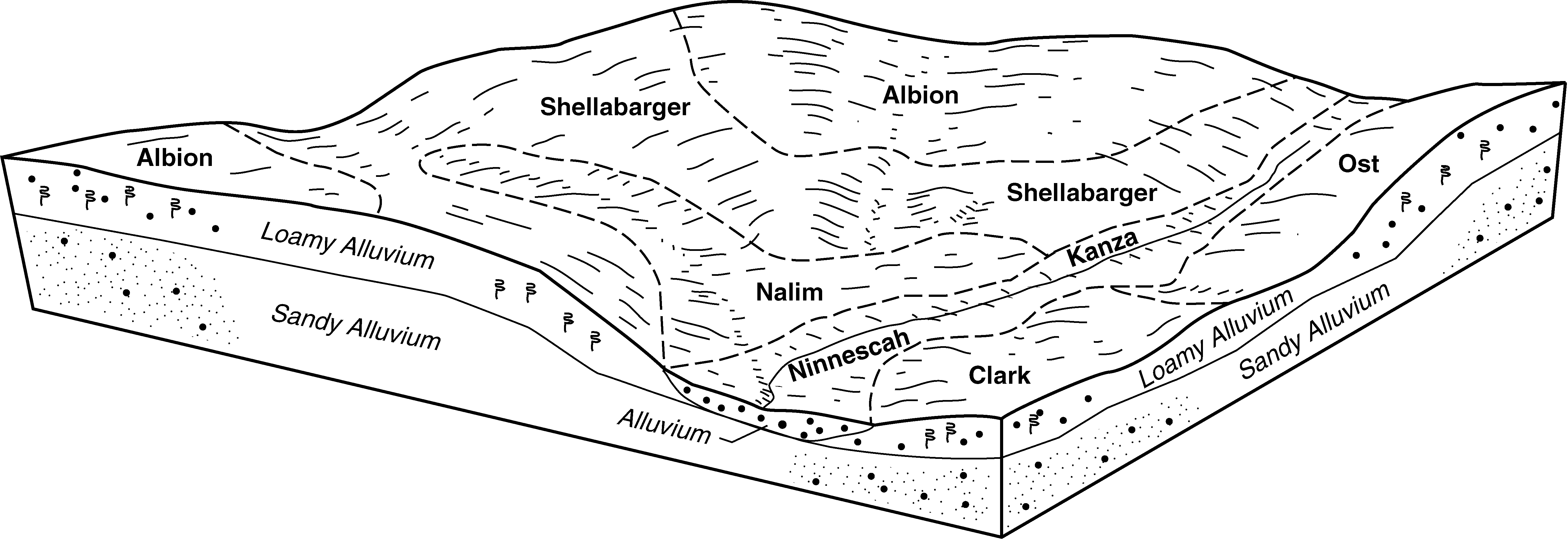
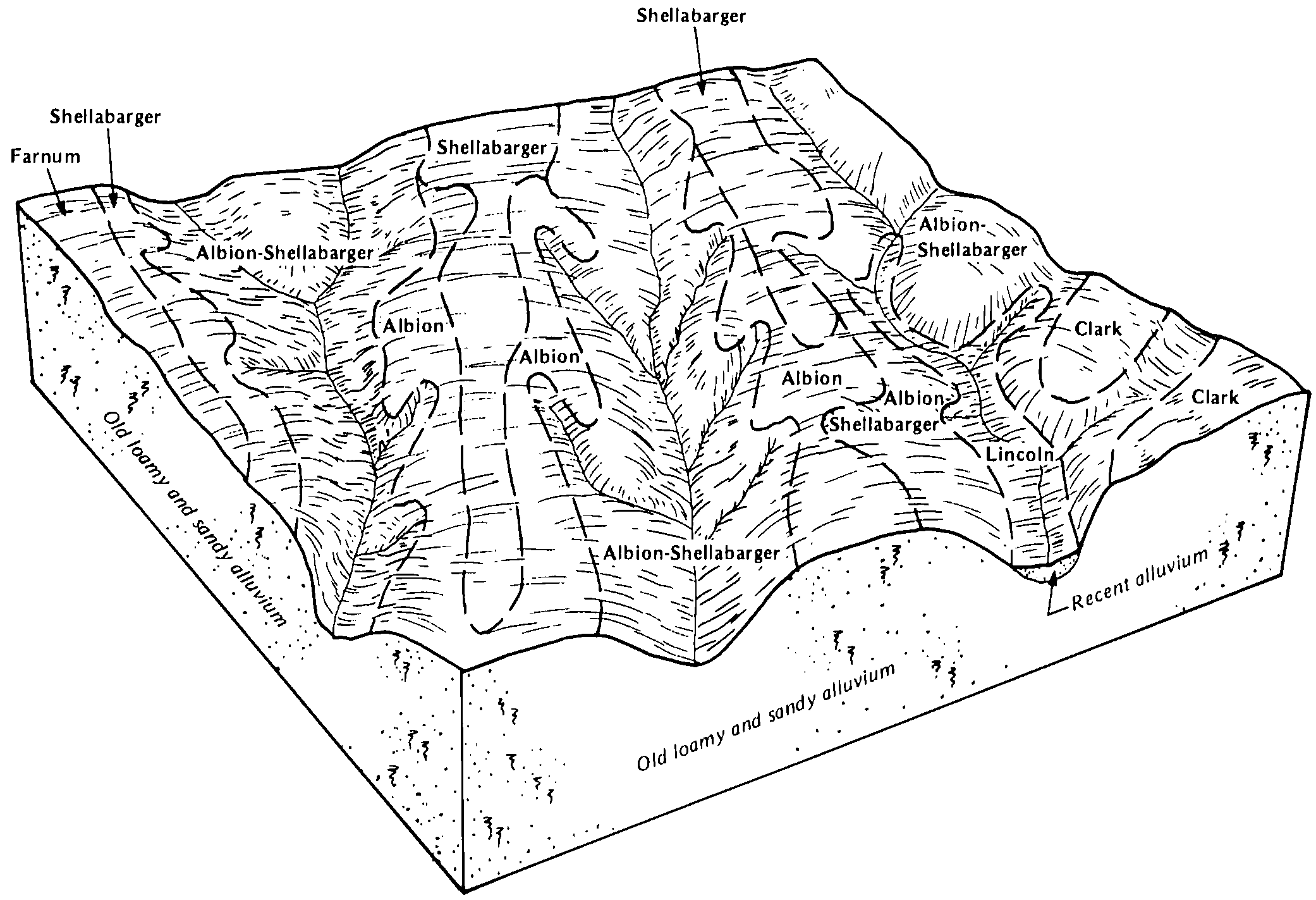
| Albion and Shellabarger sandy loams, 6 to 15 percent slopes | 5850 | 102785 | 1382448 | 2xlhq | ks007 | 1973 | 1:24000 |
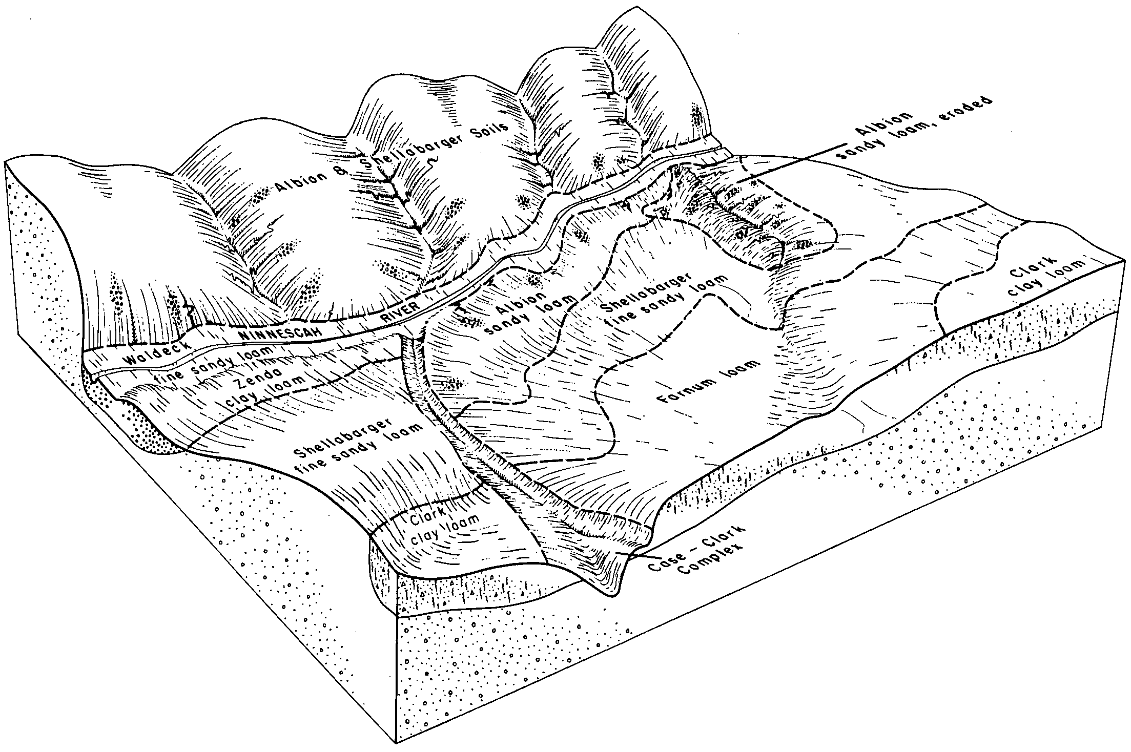
Albion-Shellabarger sandy loams, 3 to 15 percent slopes | 5859 | 22753 | 1382454 | 1hdk9 | ks007 | 1973 | 1:24000 |
Shellabarger sandy loam, 3 to 6 percent slopes | 5957 | 12383 | 1382523 | 1hdmj | ks007 | 1973 | 1:24000 |
Shellabarger sandy loam, 3 to 6 percent slopes, eroded | 5958 | 3894 | 1382524 | 2tt5s | ks007 | 1973 | 1:24000 |
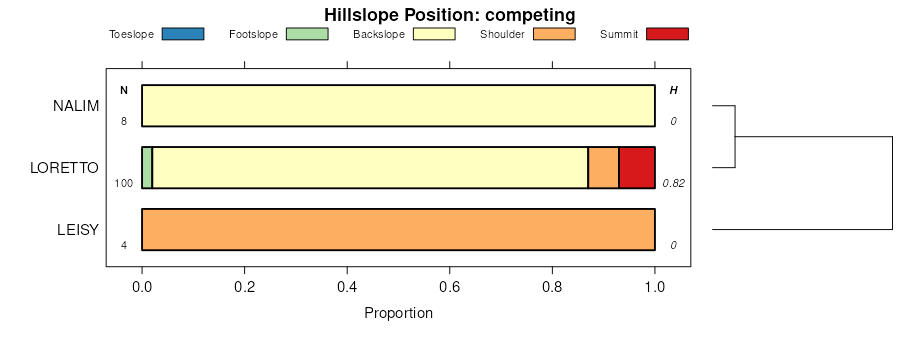
Nalim and Shellabarger fine sandy loams, 0 to 1 percent slopes | 5981 | 2820 | 2478788 | 2tt4j | ks007 | 1973 | 1:24000 |
Albion-Shellabarger sandy loams, 1 to 3 percent slopes | 5858 | 1423 | 1382453 | 2tt5m | ks007 | 1973 | 1:24000 |
Shellabarger sandy loam, 1 to 3 percent slopes | 5956 | 1034 | 1382522 | 2tt54 | ks007 | 1973 | 1:24000 |
Shellabarger fine sandy loam, 0 to 1 percent slopes | 5948 | 101 | 1382520 | 2tt58 | ks007 | 1973 | 1:24000 |
Shellabarger fine sandy loam, 1 to 3 percent slopes | 5949 | 31 | 1382521 | 2tt57 | ks007 | 1973 | 1:24000 |
Albion-Shellabarger sandy loams, 3 to 15 percent slopes | 5859 | 15268 | 1381696 | 1hcrv | ks025 | 1980 | 1:24000 |
Shellabarger loam, 3 to 6 percent slopes | 5952 | 2505 | 1381744 | 1hctd | ks025 | 1980 | 1:24000 |
Shellabarger sandy loam, 1 to 3 percent slopes | 5956 | 23 | 1381745 | 1hctf | ks025 | 1980 | 1:24000 |
Albion-Shellabarger sandy loams, 3 to 15 percent slopes | 5859 | 49535 | 1381237 | 1hc91 | ks033 | 1987 | 1:24000 |
Shellabarger sandy loam, 1 to 3 percent slopes | 5956 | 17281 | 1381290 | 1hcbr | ks033 | 1987 | 1:24000 |
Shellabarger sandy loam, 3 to 6 percent slopes | 5957 | 7014 | 1381291 | 1hcbs | ks033 | 1987 | 1:24000 |
Shellabarger sandy loam, 0 to 1 percent slopes | 5955 | 3604 | 1381289 | 1hcbq | ks033 | 1987 | 1:24000 |
Shellabarger loam, 3 to 6 percent slopes | 5952 | 5 | 1381288 | 1hcbp | ks033 | 1987 | 1:24000 |
Shellabarger fine sandy loam, 1 to 3 percent slopes | 5949 | 30447 | 1382736 | 2tt57 | ks077 | 1965 | 1:24000 |
Shellabarger fine sandy loam, 3 to 6 percent slopes | 5950 | 10081 | 1382737 | 2tt59 | ks077 | 1965 | 1:24000 |
Shellabarger and Albion soils, 7 to 15 percent slopes | 5946 | 6286 | 1382734 | 2tt5n | ks077 | 1965 | 1:24000 |
Shellabarger fine sandy loam, 3 to 6 percent slopes, eroded | 5951 | 4250 | 1382738 | 2tt5b | ks077 | 1965 | 1:24000 |
Shellabarger fine sandy loam, 0 to 1 percent slopes | 5948 | 3320 | 1382735 | 2tt58 | ks077 | 1965 | 1:24000 |
Albion and Shellabarger sandy loams, 6 to 15 percent slopes | 5850 | 3165 | 1382665 | 2xlhq | ks077 | 1965 | 1:24000 |
Shellabarger sandy loam, 1 to 3 percent slopes | 5956 | 890 | 1382741 | 2tt54 | ks077 | 1965 | 1:24000 |
Shellabarger loamy fine sand, 0 to 3 percent slopes | 5953 | 305 | 1382739 | 2tt5q | ks077 | 1965 | 1:24000 |
Shellabarger sandy loam, 3 to 6 percent slopes | 5957 | 165 | 1382742 | 1hdvl | ks077 | 1965 | 1:24000 |
Shellabarger loamy sand, 0 to 3 percent slopes | 5954 | 161 | 1382740 | 2tt5r | ks077 | 1965 | 1:24000 |
Shellabarger sandy loam, 3 to 6 percent slopes, eroded | 5958 | 53 | 1382743 | 2tt5s | ks077 | 1965 | 1:24000 |
Nalim-Shellabarger sandy loams, 0 to 1 percent slopes | 5896 | 3677 | 1473672 | 2tt4g | ks079 | 1970 | 1:24000 |
Shellabarger sandy loam, 1 to 3 percent slopes | 5956 | 89329 | 1444812 | 2tt54 | ks095 | 1977 | 1:24000 |
Shellabarger-Nalim complex, 1 to 3 percent slopes | 5960 | 27217 | 1444816 | 2tt5v | ks095 | 1977 | 1:24000 |
Shellabarger sandy loam, 3 to 6 percent slopes | 5957 | 20099 | 1444813 | 30x0x | ks095 | 1977 | 1:24000 |
Shellabarger sandy loam, 3 to 6 percent slopes, eroded | 5958 | 7445 | 1444814 | 2tt5s | ks095 | 1977 | 1:24000 |
Shellabarger loamy sand, 0 to 3 percent slopes | 5954 | 3042 | 1444810 | 2tt5r | ks095 | 1977 | 1:24000 |
Nalim and Shellabarger fine sandy loams, 0 to 1 percent slopes | 5981 | 1672 | 2478789 | 2tt4j | ks095 | 1977 | 1:24000 |
Shellabarger fine sandy loam, 1 to 3 percent slopes | 5949 | 1360 | 1444807 | 2tt57 | ks095 | 1977 | 1:24000 |
Albion and Shellabarger sandy loams, 6 to 15 percent slopes | 5850 | 1075 | 1444767 | 2xlhq | ks095 | 1977 | 1:24000 |
Albion-Shellabarger sandy loams, 1 to 3 percent slopes | 5858 | 263 | 1444773 | 2tt5m | ks095 | 1977 | 1:24000 |
Shellabarger, eroded, and Albion soils, 6 to 15 percent slopes | 5959 | 199 | 1444815 | 2tt5t | ks095 | 1977 | 1:24000 |
Shellabarger fine sandy loam, 3 to 6 percent slopes | 5950 | 116 | 1444808 | 2tt59 | ks095 | 1977 | 1:24000 |
Shellabarger sandy loam, 0 to 1 percent slopes | 5955 | 105 | 1444811 | 2tt55 | ks095 | 1977 | 1:24000 |
Shellabarger fine sandy loam, 0 to 1 percent slopes | 5948 | 47 | 1444806 | 2tt58 | ks095 | 1977 | 1:24000 |
Shellabarger and Nalim soils, 3 to 6 percent slopes | 5947 | 36 | 1444805 | 2tt5p | ks095 | 1977 | 1:24000 |
Shellabarger fine sandy loam, 3 to 6 percent slopes, eroded | 5951 | 25 | 1444809 | 2tt5b | ks095 | 1977 | 1:24000 |
Albion-Shellabarger sandy loams, 3 to 15 percent slopes | 5859 | 10890 | 1380485 | 1hbhs | ks097 | 1983 | 1:24000 |
Shellabarger loam, 3 to 6 percent slopes | 5952 | 3504 | 1380544 | 1hbkp | ks097 | 1983 | 1:24000 |
Albion and Shellabarger sandy loams, 6 to 15 percent slopes | 5850 | 919 | 1454922 | 2xlhq | ks097 | 1983 | 1:24000 |
Shellabarger sandy loam, 3 to 6 percent slopes | 5957 | 123 | 1380546 | 1hbkr | ks097 | 1983 | 1:24000 |
Shellabarger fine sandy loam, 1 to 3 percent slopes | 5949 | 8 | 1380543 | 2tt57 | ks097 | 1983 | 1:24000 |
Shellabarger sandy loam, 1 to 3 percent slopes | 5956 | 7 | 1380545 | 1hbkq | ks097 | 1983 | 1:24000 |
Albion and Shellabarger sandy loams, 6 to 15 percent slopes | 5850 | 29892 | 1445123 | 2xlhq | ks151 | 1965 | 1:24000 |
Shellabarger fine sandy loam, 1 to 3 percent slopes | 5949 | 11337 | 1445166 | 2tt57 | ks151 | 1965 | 1:24000 |
Shellabarger sandy loam, 1 to 3 percent slopes | 5956 | 2098 | 1445169 | 2tt54 | ks151 | 1965 | 1:24000 |
Shellabarger fine sandy loam, 3 to 6 percent slopes, eroded | 5951 | 1995 | 1445167 | 2tt5b | ks151 | 1965 | 1:24000 |
Shellabarger fine sandy loam, 0 to 1 percent slopes | 5948 | 620 | 1445165 | 2tt58 | ks151 | 1965 | 1:24000 |
Shellabarger sandy loam, 0 to 1 percent slopes | 5955 | 71 | 1445168 | 2tt55 | ks151 | 1965 | 1:24000 |
Shellabarger sandy loam, 3 to 6 percent slopes | 5957 | 26 | 1445170 | 1khtd | ks151 | 1965 | 1:24000 |
Shellabarger sandy loam, 1 to 3 percent slopes | 5956 | 61630 | 1443851 | 2tt54 | ks155 | 1999 | 1:24000 |
Shellabarger-Nalim complex, 1 to 3 percent slopes | 5960 | 35631 | 1443853 | 2tt5v | ks155 | 1999 | 1:24000 |
Albion-Shellabarger sandy loams, 1 to 3 percent slopes | 5858 | 23789 | 1443820 | 2tt5m | ks155 | 1999 | 1:24000 |
Shellabarger sandy loam, 0 to 1 percent slopes | 5955 | 11406 | 1443850 | 2tt55 | ks155 | 1999 | 1:24000 |
Shellabarger, eroded, and Albion soils, 6 to 15 percent slopes | 5959 | 5098 | 1443852 | 2tt5t | ks155 | 1999 | 1:24000 |
Shellabarger loamy sand, 0 to 3 percent slopes | 5954 | 2674 | 1443849 | 2tt5r | ks155 | 1999 | 1:24000 |
Shellabarger and Nalim soils, 3 to 6 percent slopes | 5947 | 1605 | 1443848 | 2tt5p | ks155 | 1999 | 1:24000 |
Shellabarger sandy loam, 1 to 3 percent slopes | 5956 | 19667 | 1443986 | 2tt54 | ks173 | 1976 | 1:24000 |
Nalim-Shellabarger sandy loams, 0 to 1 percent slopes | 5896 | 12214 | 1443978 | 2tt4g | ks173 | 1976 | 1:24000 |
Shellabarger-Nalim complex, 1 to 3 percent slopes | 5960 | 11445 | 1443989 | 2tt5v | ks173 | 1976 | 1:24000 |
Shellabarger sandy loam, 3 to 6 percent slopes | 5957 | 2836 | 1443987 | 30x0x | ks173 | 1976 | 1:24000 |
Albion-Shellabarger sandy loams, 1 to 3 percent slopes | 5858 | 2195 | 1443969 | 2tt5m | ks173 | 1976 | 1:24000 |
Albion and Shellabarger sandy loams, 6 to 15 percent slopes | 5850 | 760 | 1443967 | 2xlhq | ks173 | 1976 | 1:24000 |
Shellabarger sandy loam, 3 to 6 percent slopes, eroded | 5958 | 712 | 1443988 | 2tt5s | ks173 | 1976 | 1:24000 |
Shellabarger-Nalim complex, 1 to 3 percent slopes | 5960 | 7007 | 2478770 | 2tt5v | ks185 | 1975 | 1:24000 |
Nalim and Shellabarger fine sandy loams, 0 to 1 percent slopes | 5981 | 3300 | 1677422 | 2tt4j | ks185 | 1975 | 1:24000 |
Albion-Shellabarger sandy loams, 1 to 3 percent slopes | 5858 | 51 | 1443645 | 2tt5m | ks185 | 1975 | 1:24000 |
Shellabarger sandy loam, 1 to 3 percent slopes | 5956 | 22462 | 1444621 | 2tt54 | ks191 | 1974 | 1:24000 |
Shellabarger sandy loam, 3 to 6 percent slopes | 5957 | 3151 | 1444622 | 30x0x | ks191 | 1974 | 1:24000 |
Shellabarger sandy loam, 3 to 6 percent slopes, eroded | 5958 | 1185 | 1444623 | 2tt5s | ks191 | 1974 | 1:24000 |
Shellabarger and Albion soils, 7 to 15 percent slopes | 5946 | 5 | 1444620 | 2tt5n | ks191 | 1974 | 1:24000 |


