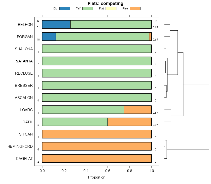
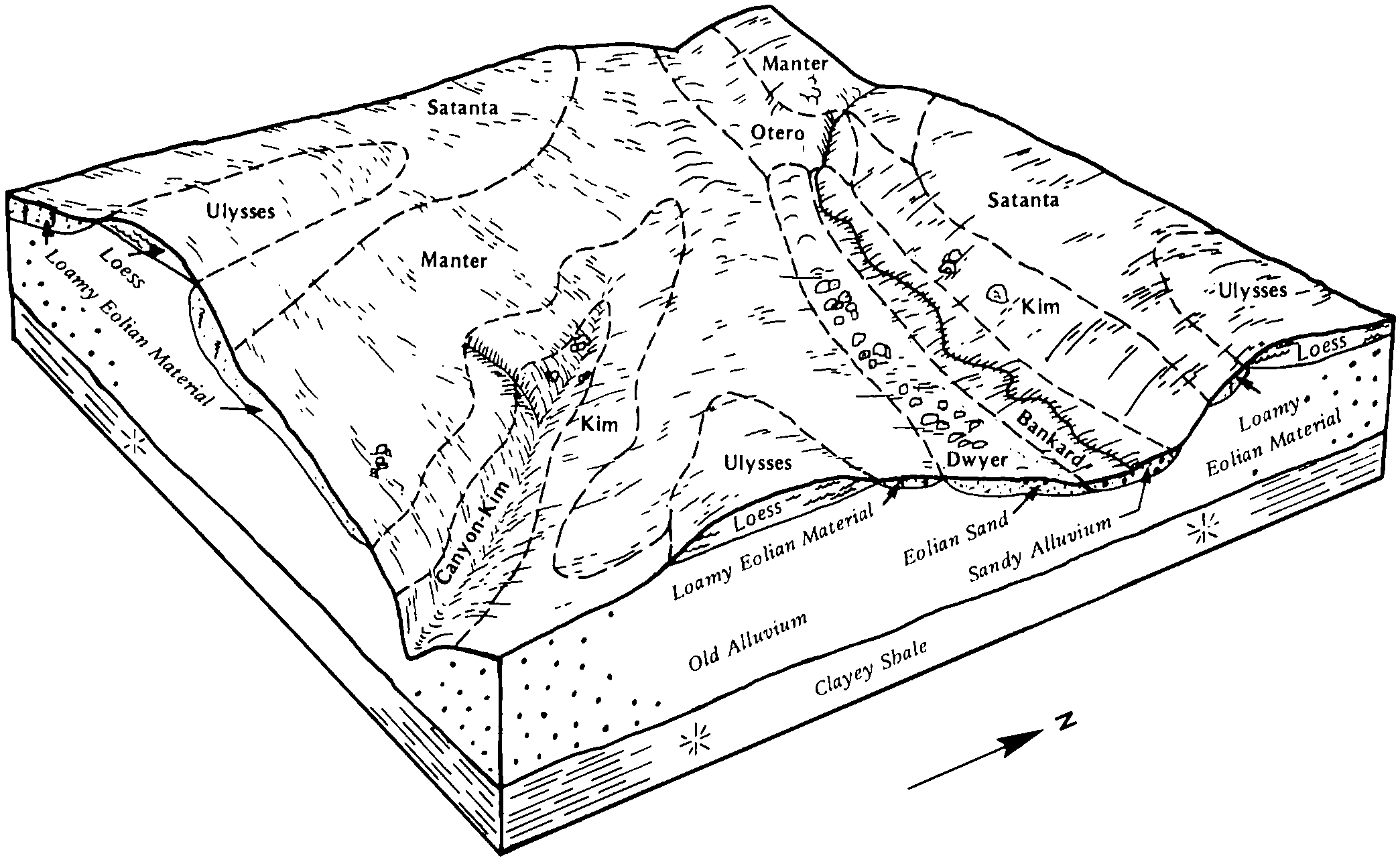
| Satanta loam, 0 to 1 percent slopes | SnA | 1081 | 94073 | 2wz89 | co001 | 1968 | 1:20000 |
Satanta loam, 1 to 3 percent slopes | SnB | 775 | 94074 | 2w5f3 | co001 | 1968 | 1:20000 |
Satanta fine sandy loam, 0 to 1 percent slopes | 1808 | 3886 | 2509194 | 2wz91 | co009 | 1966 | 1:20000 |
Satanta fine sandy loam, 1 to 3 percent slopes | 1809 | 827 | 2509195 | 2wz99 | co009 | 1966 | 1:20000 |
Satanta loam, dry, 0 to 3 percent slopes | SnB | 11685 | 94283 | 2zcs3 | co011 | 1965 | 1:15840 |
Satanta loam, 0 to 3 percent slopes | 38 | 42514 | 94327 | 354t | co017 | 1985 | 1:24000 |
Satanta-Colby complex, 3 to 5 percent slopes | 39 | 39927 | 94328 | 354v | co017 | 1985 | 1:24000 |
Colby-Satanta complex, 5 to 12 percent slopes | 10 | 12635 | 94297 | 353v | co017 | 1985 | 1:24000 |
Satanta-Sampson, loams, 0 to 3 percent slopes, rarely flooded | 78 | 33875 | 96879 | 37t4 | co063 | 1996 | 1:24000 |
Satanta loam, 1 to 3 percent slopes | 76 | 19959 | 96874 | 2w5f2 | co063 | 1996 | 1:24000 |
Satanta-Ulmet loams, 1 to 3 percent slopes | 79 | 13495 | 96817 | 37r4 | co063 | 1996 | 1:24000 |
Satanta-Colby complex, 3 to 5 percent slopes | 77 | 75 | 96875 | 37t0 | co063 | 1996 | 1:24000 |
Satanta loam, dry, 1 to 3 percent slopes | 182 | 8196 | 105263 | 3jjl | co073 | 2001 | 1:24000 |
Satanta loam, 1 to 3 percent slopes | 181 | 6398 | 105262 | 2w5f2 | co073 | 2001 | 1:24000 |
Satanta loam, 1 to 3 percent slopes | 100 | 27358 | 94461 | 2w5f3 | co075 | 1974 | 1:24000 |
Satanta loam, 0 to 1 percent slopes | 99 | 6546 | 94586 | 2wz89 | co075 | 1974 | 1:24000 |
Satanta loam, wet | 103 | 6519 | 94464 | 3597 | co075 | 1974 | 1:24000 |
Satanta loam, watertable | 102 | 1485 | 94463 | 3596 | co075 | 1974 | 1:24000 |
Satanta loam, 3 to 5 percent slopes | 101 | 263 | 94462 | 3595 | co075 | 1974 | 1:24000 |
Satanta loam | 65 | 1859 | 95029 | 35wg | co121 | 1982 | 1:24000 |
Newlin-Satanta complex, 5 to 20 percent slopes | NsE | 14038 | 498743 | jqzh | co622 | 1968 | 1:20000 |
Buick-Satanta loams, 3 to 9 percent slopes | BwD | 2825 | 498710 | jqyf | co622 | 1968 | 1:20000 |
Satanta loam | Sn | 1608 | 498764 | jr05 | co622 | 1968 | 1:20000 |
Satanta loam, calcareous variant, 9 to 25 percent slopes | SrE | 283 | 498766 | jr07 | co622 | 1968 | 1:20000 |
Satanta loam, calcareous variant, 3 to 9 percent slopes | SrD | 219 | 498765 | jr06 | co622 | 1968 | 1:20000 |
Satanta loam, 0 to 3 percent slopes | 79 | 5299 | 95443 | 369t | co625 | 1975 | 1:24000 |
Satanta-Neville complex, 3 to 8 percent slopes | 81 | 2215 | 95446 | 369x | co625 | 1975 | 1:24000 |
Satanta loam, 3 to 5 percent slopes | 80 | 1363 | 95445 | 369w | co625 | 1975 | 1:24000 |
Altvan-Satanta loams, 3 to 9 percent slopes | 4 | 5 | 3210284 | jpwf | co643 | 1975 | 1:20000 |
Satanta loam, 1 to 3 percent slopes | 95 | 8968 | 497748 | 2w5f3 | co644 | 1980 | 1:24000 |
Altvan-Satanta loams, 0 to 3 percent slopes | 3 | 3689 | 497676 | jpw2 | co644 | 1980 | 1:24000 |
Altvan-Satanta loams, 3 to 9 percent slopes | 4 | 1732 | 497687 | jpwf | co644 | 1980 | 1:24000 |
Satanta loam, 3 to 5 percent slopes | 96 | 1716 | 497749 | jpyf | co644 | 1980 | 1:24000 |
Satanta loam, 0 to 1 percent slopes | 94 | 1543 | 497747 | 2wz89 | co644 | 1980 | 1:24000 |
Satanta Variant clay loam, 0 to 3 percent slopes | 98 | 1439 | 497751 | jpyh | co644 | 1980 | 1:24000 |
Satanta loam, 1 to 3 percent slopes | 1811 | 10606 | 1149582 | 2w5f2 | ks023 | 1987 | 1:24000 |
Satanta loam, 0 to 1 percent slopes | 1810 | 8767 | 1149581 | 2w5f0 | ks023 | 1987 | 1:24000 |
Satanta fine sandy loam, 1 to 3 percent slopes | 1809 | 113 | 1149580 | 2wz9b | ks023 | 1987 | 1:24000 |
Satanta loam, 0 to 1 percent slopes | 1810 | 3793 | 1381743 | 2w5f0 | ks025 | 1980 | 1:24000 |
Satanta fine sandy loam, 0 to 1 percent slopes | 1808 | 26 | 1381742 | 1hctb | ks025 | 1980 | 1:24000 |
Satanta loam, 0 to 1 percent slopes | 1810 | 26714 | 1152346 | 2w5f0 | ks055 | 1962 | 1:24000 |
Satanta-Lubbock complex, 0 to 3 percent slopes | 1816 | 4511 | 2509184 | 2mslk | ks057 | 1962 | 1:24000 |
Satanta loam, 1 to 3 percent slopes | 1811 | 187 | 1380468 | 2w5f2 | ks057 | 1962 | 1:24000 |
Satanta loam, 0 to 1 percent slopes | 1810 | 171 | 1380467 | 2w5f0 | ks057 | 1962 | 1:24000 |
Satanta loam, 0 to 1 percent slopes | 1810 | 12067 | 1380676 | 2w5f0 | ks067 | 1965 | 1:24000 |
Satanta fine sandy loam, 0 to 1 percent slopes | 1808 | 9762 | 1380674 | 2wz91 | ks067 | 1965 | 1:24000 |
Satanta fine sandy loam, 1 to 3 percent slopes | 1809 | 1928 | 1380675 | 2wz99 | ks067 | 1965 | 1:24000 |
Satanta-Vona complex, 0 to 3 percent slopes | 1815 | 235 | 2509180 | 2mjc8 | ks067 | 1965 | 1:24000 |
Satanta loam, 0 to 1 percent slopes | 1810 | 13749 | 1380599 | 2w5f0 | ks069 | 1965 | 1:24000 |
Satanta loam, 1 to 3 percent slopes | 1811 | 2083 | 1380600 | 2w5f2 | ks069 | 1965 | 1:24000 |
Satanta loam, 0 to 1 percent slopes | 1810 | 9827 | 1380634 | 2w5f0 | ks081 | 1965 | 1:24000 |
Satanta fine sandy loam, 0 to 1 percent slopes | 1808 | 1700 | 1380632 | 2wz91 | ks081 | 1965 | 1:24000 |
Satanta fine sandy loam, 1 to 3 percent slopes | 1809 | 1039 | 1380633 | 2wz99 | ks081 | 1965 | 1:24000 |
Satanta-Vona complex, 0 to 3 percent slopes | 1815 | 3605 | 2509182 | 2mjc8 | ks093 | 1961 | 1:24000 |
Satanta loam, 0 to 1 percent slopes | 1810 | 508 | 1152044 | 2w5f0 | ks101 | 1966 | 1:24000 |
Manter-Satanta complex, 1 to 3 percent slopes | 1673 | 7965 | 1381795 | 2y7z9 | ks119 | 1973 | 1:24000 |
Satanta loam, 0 to 1 percent slopes | 1810 | 5219 | 1381815 | 2w5f0 | ks119 | 1973 | 1:24000 |
Satanta fine sandy loam, 0 to 1 percent slopes | 1808 | 3986 | 1381814 | 1hcwn | ks119 | 1973 | 1:24000 |
Satanta loam, 1 to 3 percent slopes | 1811 | 2529 | 1381816 | 2w5f2 | ks119 | 1973 | 1:24000 |
Satanta fine sandy loam, 0 to 1 percent slopes | 1808 | 3254 | 2509190 | 2mjc6 | ks129 | 1995 | 1:24000 |
Satanta loam, 0 to 1 percent slopes | 1810 | 2752 | 1382611 | 2w5f0 | ks129 | 1995 | 1:24000 |
Satanta-Keith complex, 1 to 3 percent slopes | 1812 | 8076 | 2509177 | 2mb0b | ks171 | 1963 | 1:24000 |
Satanta loam, 0 to 1 percent slopes | 1810 | 363 | 1151996 | 2w5f0 | ks171 | 1963 | 1:24000 |
Satanta fine sandy loam, 0 to 1 percent slopes | 1808 | 5771 | 2509186 | 2wz91 | ks175 | 1963 | 1:24000 |
Satanta fine sandy loam, 1 to 3 percent slopes | 1809 | 2151 | 2509187 | 2wz99 | ks175 | 1963 | 1:24000 |
Manter-Satanta complex, 1 to 3 percent slopes | 1673 | 1847 | 1382627 | 2y7z9 | ks175 | 1963 | 1:24000 |
Satanta fine sandy loam, 0 to 1 percent slopes | 1808 | 19386 | 2509188 | 2wz91 | ks187 | 1959 | 1:24000 |
Satanta fine sandy loam, 1 to 3 percent slopes | 1809 | 7482 | 2509189 | 2wz99 | ks187 | 1959 | 1:24000 |
Satanta loam, 0 to 1 percent slopes | 1810 | 233 | 1382570 | 2w5f0 | ks187 | 1959 | 1:24000 |
Satanta loam, 0 to 1 percent slopes | 1810 | 1687 | 1539811 | 2w5f0 | ks189 | 2005 | 1:24000 |
Satanta loam, 1 to 3 percent slopes | 1811 | 5398 | 1150207 | 2w5f2 | ks199 | 1984 | 1:24000 |
Satanta fine sandy loam, 1 to 3 percent slopes | 1809 | 11543 | 1692507 | 1tt60 | ne007 | 1988 | 1:20000 |
Satanta-Altvan complex, 3 to 6 percent slopes | 1820 | 9082 | 1692508 | 1tt61 | ne007 | 1988 | 1:20000 |
Altvan-Satanta loams, 0 to 1 percent slopes | 1512 | 341 | 2228141 | 2dskj | ne007 | 1988 | 1:20000 |
Satanta loam, gravelly substratum, 3 to 6 percent slopes | 1817 | 23 | 2228154 | 2dsky | ne007 | 1988 | 1:20000 |
Altvan-Satanta fine sandy loams, 1 to 3 percent slopes | 1511 | 19 | 2228140 | 2dskh | ne007 | 1988 | 1:20000 |
Satanta fine sandy loam, 1 to 3 percent slopes | 1809 | 13505 | 357826 | 2wgfb | ne013 | 1980 | 1:20000 |
Manter-Satanta fine sandy loams, 3 to 6 percent slopes | 1684 | 4500 | 357810 | d0b8 | ne013 | 1980 | 1:20000 |
Satanta fine sandy loam, 3 to 6 percent slopes | 1812 | 3832 | 357827 | 2wgfm | ne013 | 1980 | 1:20000 |
Manter-Satanta fine sandy loams, 0 to 3 percent slopes | 1683 | 2986 | 357809 | d0b7 | ne013 | 1980 | 1:20000 |
Satanta fine sandy loam, 6 to 9 percent slopes | 1813 | 830 | 357828 | 2wgfn | ne013 | 1980 | 1:20000 |
Satanta very fine sandy loam, 3 to 6 percent slopes | 1819 | 1053 | 1699062 | 2wz9m | ne029 | 1980 | 1:20000 |
Satanta very fine sandy loam, 1 to 3 percent slopes | 1818 | 982 | 1699061 | 2wz9l | ne029 | 1980 | 1:20000 |
Satanta loam, 3 to 6 percent slopes | 1814 | 99 | 2219528 | 2dhlp | ne029 | 1980 | 1:20000 |
Satanta fine sandy loam, 1 to 3 percent slopes | 1809 | 76 | 2219504 | 2wz9b | ne029 | 1980 | 1:20000 |
Satanta loam, 1 to 3 percent slopes | 1811 | 48 | 2219527 | 2w5f2 | ne029 | 1980 | 1:20000 |
Satanta fine sandy loam, 1 to 3 percent slopes | 1809 | 2422 | 100429 | 2wgfb | ne031 | 1995 | 1:24000 |
Satanta loam, gravelly substratum, 1 to 3 percent slopes | 1816 | 13081 | 1698709 | 1v0n2 | ne033 | 1989 | 1:20000 |
Satanta loam, gravelly substratum, 3 to 6 percent slopes | 1817 | 5660 | 1698710 | 1v0n3 | ne033 | 1989 | 1:20000 |
Satanta loam, gravelly substratum, 0 to 1 percent slopes | 1815 | 2255 | 1698708 | 1v0n1 | ne033 | 1989 | 1:20000 |
Altvan-Eckley-Satanta complex, 3 to 9 percent slopes | 1509 | 279 | 2219696 | 2dhs3 | ne033 | 1989 | 1:20000 |
Satanta-Johnstown-Altvan loams, 1 to 3 percent slopes | 1825 | 144 | 2219697 | 2dhs4 | ne033 | 1989 | 1:20000 |
Satanta-Altvan complex, 3 to 6 percent slopes | 1820 | 35 | 2219689 | 2dhrw | ne033 | 1989 | 1:20000 |
Satanta-Canyon complex, 12 to 20 percent slopes | 1822 | 1063 | 2217552 | 2dfjy | ne045 | 1973 | 1:20000 |
Satanta-Canyon complex, 6 to 12 percent slopes | 1823 | 328 | 2217553 | 2dfjz | ne045 | 1973 | 1:20000 |
Satanta fine sandy loam, 3 to 6 percent slopes | 1812 | 23 | 2217550 | 2wgfm | ne045 | 1973 | 1:20000 |
Satanta fine sandy loam, 6 to 9 percent slopes | 1813 | 18 | 2217551 | 2wgfn | ne045 | 1973 | 1:20000 |
Satanta-Johnstown-Altvan loams, 1 to 3 percent slopes | 1825 | 61676 | 1698824 | 1v0rs | ne049 | 2000 | 1:24000 |
Johnstown-Satanta-Richfield loams, 0 to 2 percent slopes | 3203 | 23304 | 1698808 | 1v0r8 | ne049 | 2000 | 1:24000 |
Altvan-Eckley-Satanta complex, 3 to 9 percent slopes | 1509 | 19631 | 1698795 | 1v0qv | ne049 | 2000 | 1:24000 |
Satanta-Altvan complex, 3 to 6 percent slopes | 1820 | 15284 | 1698822 | 1v0rq | ne049 | 2000 | 1:24000 |
Satanta-Ascalon complex, 0 to 1 percent slopes | 1821 | 1738 | 1698823 | 1v0rr | ne049 | 2000 | 1:24000 |
Satanta fine sandy loam, 1 to 3 percent slopes | 1809 | 5525 | 1699104 | 2wz9b | ne057 | 1995 | 1:24000 |
Satanta loam, 1 to 3 percent slopes | 1811 | 29228 | 1698912 | 2w5f2 | ne101 | 1990 | 1:20000 |
Satanta loam, 3 to 6 percent slopes | 1814 | 20124 | 1698913 | 1v0vn | ne101 | 1990 | 1:20000 |
Satanta-Dix complex, 3 to 9 percent slopes | 1824 | 6512 | 1698914 | 1v0vp | ne101 | 1990 | 1:20000 |
Satanta loam, 0 to 1 percent slopes | 1810 | 1070 | 1698911 | 2w5f0 | ne101 | 1990 | 1:20000 |
Satanta very fine sandy loam, 3 to 6 percent slopes | 1819 | 852 | 2229428 | 2wz9m | ne101 | 1990 | 1:20000 |
Satanta very fine sandy loam, 1 to 3 percent slopes | 1818 | 747 | 2229427 | 2wz9l | ne101 | 1990 | 1:20000 |
Satanta-Johnstown-Altvan loams, 1 to 3 percent slopes | 1825 | 581 | 2219580 | 2dhnc | ne101 | 1990 | 1:20000 |
Johnstown-Satanta-Richfield loams, 0 to 2 percent slopes | 3203 | 136 | 2219582 | 2dhnf | ne101 | 1990 | 1:20000 |
Altvan-Eckley-Satanta complex, 3 to 9 percent slopes | 1509 | 62 | 2219578 | 2dhn9 | ne101 | 1990 | 1:20000 |
Altvan-Satanta fine sandy loams, 1 to 3 percent slopes | 1511 | 26051 | 1692533 | 1tt6v | ne105 | 2004 | 1:24000 |
Altvan-Satanta loams, 0 to 1 percent slopes | 1512 | 16834 | 1692535 | 1tt6x | ne105 | 2004 | 1:24000 |
Satanta fine sandy loam, 1 to 3 percent slopes | 1809 | 666 | 2227927 | 2dsbm | ne105 | 2004 | 1:24000 |
Satanta loam, 3 to 6 percent slopes | 1814 | 504 | 2219740 | 2dhtj | ne111 | 1971 | 1:24000 |
Satanta very fine sandy loam, 1 to 3 percent slopes | 1818 | 17 | 2229429 | 2wz9l | ne111 | 1971 | 1:24000 |
Satanta loam, 1 to 3 percent slopes | 1811 | 10 | 2219739 | 2w5f2 | ne111 | 1971 | 1:24000 |
Satanta very fine sandy loam, 3 to 6 percent slopes | 1819 | 29591 | 2229321 | 2wz9m | ne135 | 1987 | 1:20000 |
Satanta very fine sandy loam, 1 to 3 percent slopes | 1818 | 28311 | 2229320 | 2wz9l | ne135 | 1987 | 1:20000 |
Satanta loam, 1 to 3 percent slopes | 1811 | 19662 | 1698988 | 2w5f2 | ne135 | 1987 | 1:20000 |
Satanta loam, 0 to 1 percent slopes | 1810 | 4188 | 1698987 | 2w5f0 | ne135 | 1987 | 1:20000 |
Satanta loam, 3 to 6 percent slopes | 1814 | 2148 | 1698989 | 1v0y3 | ne135 | 1987 | 1:20000 |
Satanta-Altvan complex, 3 to 6 percent slopes | 1820 | 30 | 2219572 | 2dhn3 | ne135 | 1987 | 1:20000 |
Altvan-Eckley-Satanta complex, 3 to 9 percent slopes | 1509 | 3 | 2219571 | 2dhn2 | ne135 | 1987 | 1:20000 |
Satanta fine sandy loam, 1 to 3 percent slopes | 1809 | 441 | 1653785 | 1shwx | ne157 | 1965 | 1:20000 |
Satanta fine sandy loam, 1 to 3 percent slopes | 1809 | 16376 | 100632 | 2wgfb | ne161 | 1992 | 1:20000 |
Satanta-Canyon complex, 6 to 12 percent slopes | 1823 | 13415 | 100635 | 3cq9 | ne161 | 1992 | 1:20000 |
Satanta fine sandy loam, 3 to 6 percent slopes | 1812 | 11761 | 100633 | 2wgfm | ne161 | 1992 | 1:20000 |
Satanta-Canyon complex, 12 to 20 percent slopes | 1822 | 3750 | 100636 | 3cqb | ne161 | 1992 | 1:20000 |
Satanta fine sandy loam, 6 to 9 percent slopes | 1813 | 2828 | 100634 | 2wgfn | ne161 | 1992 | 1:20000 |
Satanta very fine sandy loam, 1 to 3 percent slopes | 1818 | 4749 | 358008 | d0jn | ne165 | 1993 | 1:20000 |
Satanta very fine sandy loam, 3 to 6 percent slopes | 1819 | 1309 | 358009 | d0jp | ne165 | 1993 | 1:20000 |
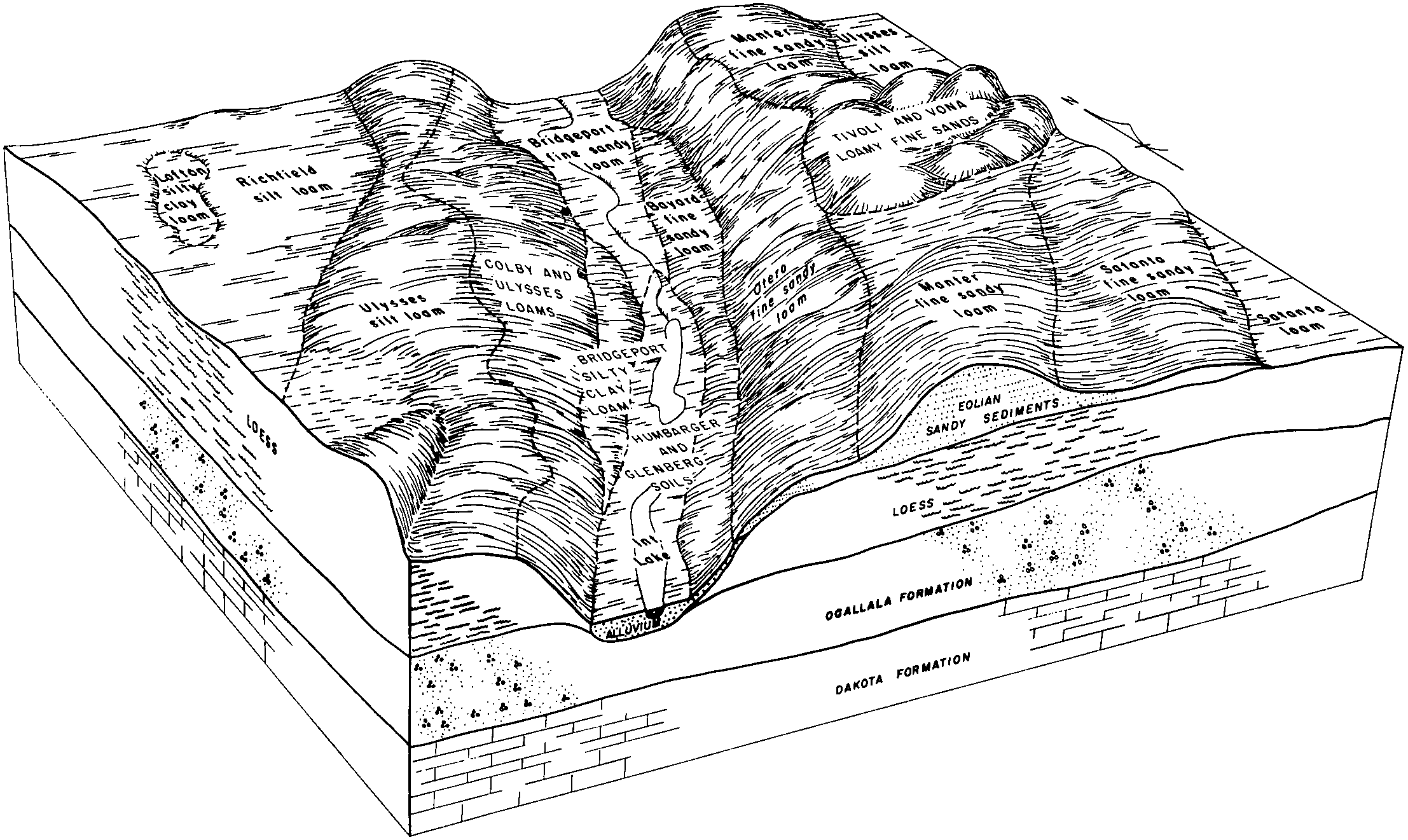
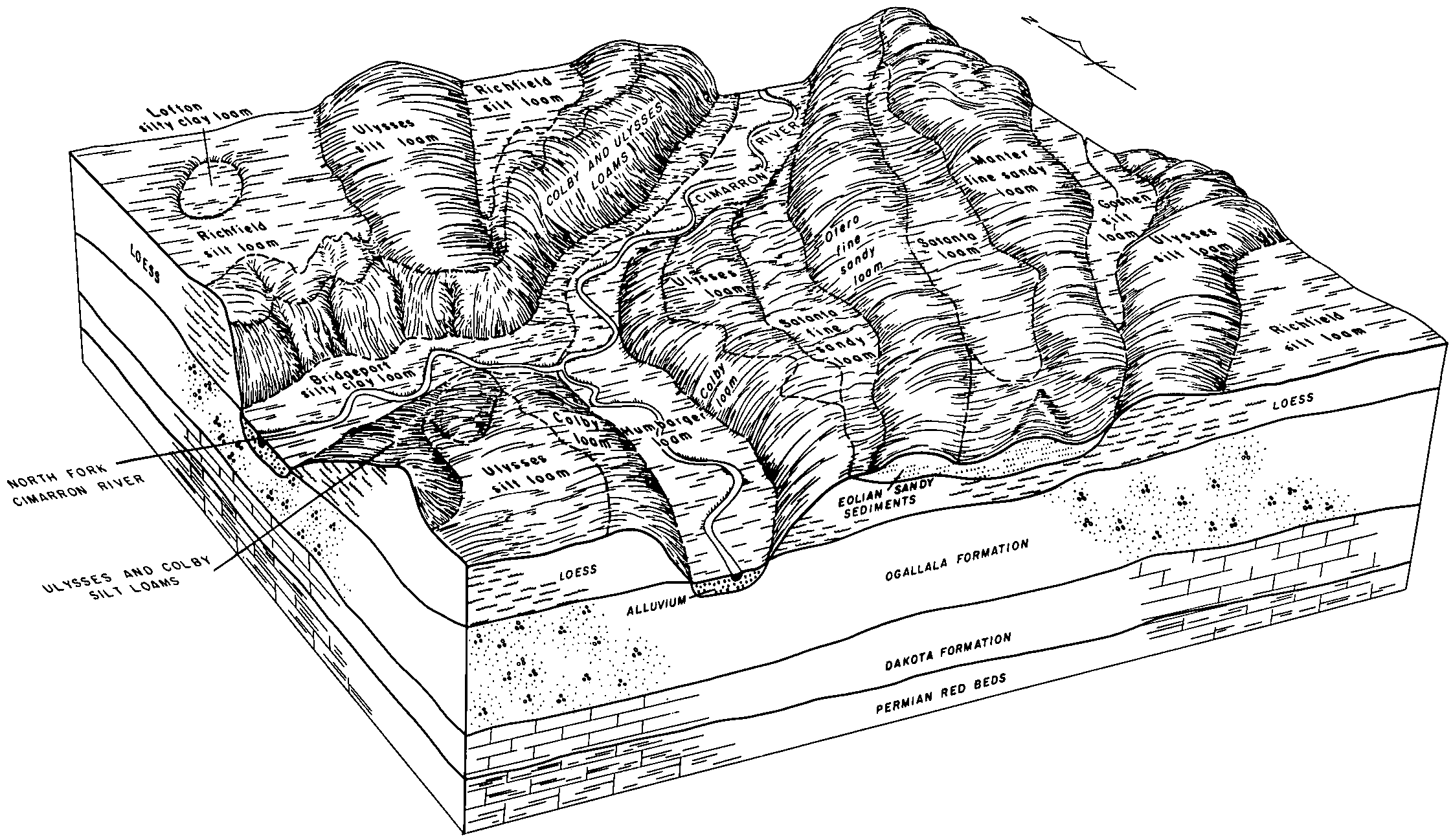
Satanta loam, 2 to 6 percent slopes | ScB | 4029 | 353232 | 2t348 | sd019 | 1970 | 1:24000 |
Satanta loam, 0 to 2 percent slopes | ScA | 2287 | 353231 | 2t347 | sd019 | 1970 | 1:24000 |
Satanta loam, 6 to 9 percent slopes | ScC | 1258 | 353233 | 2t34b | sd019 | 1970 | 1:24000 |
Satanta loam, 2 to 6 percent slopes | ScB | 2459 | 355149 | 2t348 | sd047 | 1980 | 1:24000 |
Satanta loam, 0 to 2 percent slopes | ScA | 1806 | 355148 | 2t347 | sd047 | 1980 | 1:24000 |
Satanta loam, 6 to 9 percent slopes | ScC | 449 | 355150 | 2t34b | sd047 | 1980 | 1:24000 |
Satanta loam, 2 to 6 percent slopes | SdB | 38025 | 354345 | 2t348 | sd600 | 1974 | 1:24000 |
Satanta loam, 0 to 2 percent slopes | SdA | 12735 | 354344 | 2t347 | sd600 | 1974 | 1:24000 |
Satanta-Beckton loams, 0 to 3 percent slopes | SeA | 8723 | 354347 | cwqk | sd600 | 1974 | 1:24000 |
Satanta loam, 6 to 9 percent slopes | SdC | 5845 | 354346 | 2t34b | sd600 | 1974 | 1:24000 |
Satanta loam, 2 to 6 percent slopes | SdB | 4218 | 355465 | 2t348 | sd601 | 1983 | 1:24000 |
Satanta loam, 0 to 2 percent slopes | SdA | 2049 | 355464 | 2t347 | sd601 | 1983 | 1:24000 |
Satanta loam, 0 to 2 percent slopes | SeA | 38746 | 2580967 | 2t347 | sd606 | 2011 | 1:24000 |
Satanta loam, 2 to 6 percent slopes | SeB | 30175 | 2580968 | 2t348 | sd606 | 2011 | 1:24000 |
Satanta-Beckton complex, 0 to 3 percent slopes | SgA | 10456 | 2580970 | cykc | sd606 | 2011 | 1:24000 |
Satanta loam, 6 to 9 percent slopes | SeC | 4285 | 2580969 | 2t34b | sd606 | 2011 | 1:24000 |
Satanta sandy loam, 0 to 2 percent slopes | SfA | 1609 | 2580996 | xgvt | sd606 | 2011 | 1:24000 |
Satanta-Urban land complex, 0 to 2 percent slopes | SkA | 1254 | 2580971 | cykd | sd606 | 2011 | 1:24000 |
Satanta-Urban land complex, 2 to 6 percent slopes | SkB | 1102 | 2580972 | cykf | sd606 | 2011 | 1:24000 |
Satanta-Beckton sandy loams, 0 to 3 percent slopes | ShA | 492 | 2580998 | xgvy | sd606 | 2011 | 1:24000 |
Satanta sandy loam, 2 to 6 percent slopes u | SfB | 123 | 2580997 | xgvw | sd606 | 2011 | 1:24000 |
Satanta-Arvada complex, 2 to 6 percent slopes | SfB | 666 | 2586440 | cyf2 | sd607 | 2011 | 1:24000 |
Satanta loam, 6 to 9 percent slopes | StC | 47 | 2582678 | 2t34b | sd611 | 2011 | 1:24000 |
Satanta loam, 1 to 6 percent slopes | 161 | 4424 | 349244 | cqdy | wy011 | 1978 | 1:24000 |
Ascalon-Satanta complex, 1 to 10 percent slopes | 17 | 3210 | 349253 | cqf7 | wy011 | 1978 | 1:24000 |
Satanta loam, 6 to 10 percent slopes | 162 | 2217 | 349245 | cqdz | wy011 | 1978 | 1:24000 |
Satanta loam, 0 to 1 percent slopes | 160 | 1453 | 349243 | 2wz89 | wy011 | 1978 | 1:24000 |
Satanta-Shingle loams, 6 to 10 percent slopes | 164 | 166 | 349247 | cqf1 | wy011 | 1978 | 1:24000 |
Satanta loam, 3 to 6 percent slopes | StC | 13975 | 104750 | 3j01 | wy615 | 1965 | 1:20000 |
Satanta loam, 0 to 1 percent slopes | StA | 13433 | 104748 | 2w5f0 | wy615 | 1965 | 1:20000 |
Satanta loam, 1 to 3 percent slopes | StB | 6711 | 104749 | 2w5f2 | wy615 | 1965 | 1:20000 |
Satanta loam, 6 to 10 percent slopes | StD | 5190 | 104751 | 3j02 | wy615 | 1965 | 1:20000 |
Rosebud and Satanta loams, 0 to 3 percent slopes | RsA | 2490 | 104741 | 3hzr | wy615 | 1965 | 1:20000 |
Satanta fine sandy loam, 0 to 3 percent slopes | SaA | 619 | 104747 | 3hzy | wy615 | 1965 | 1:20000 |
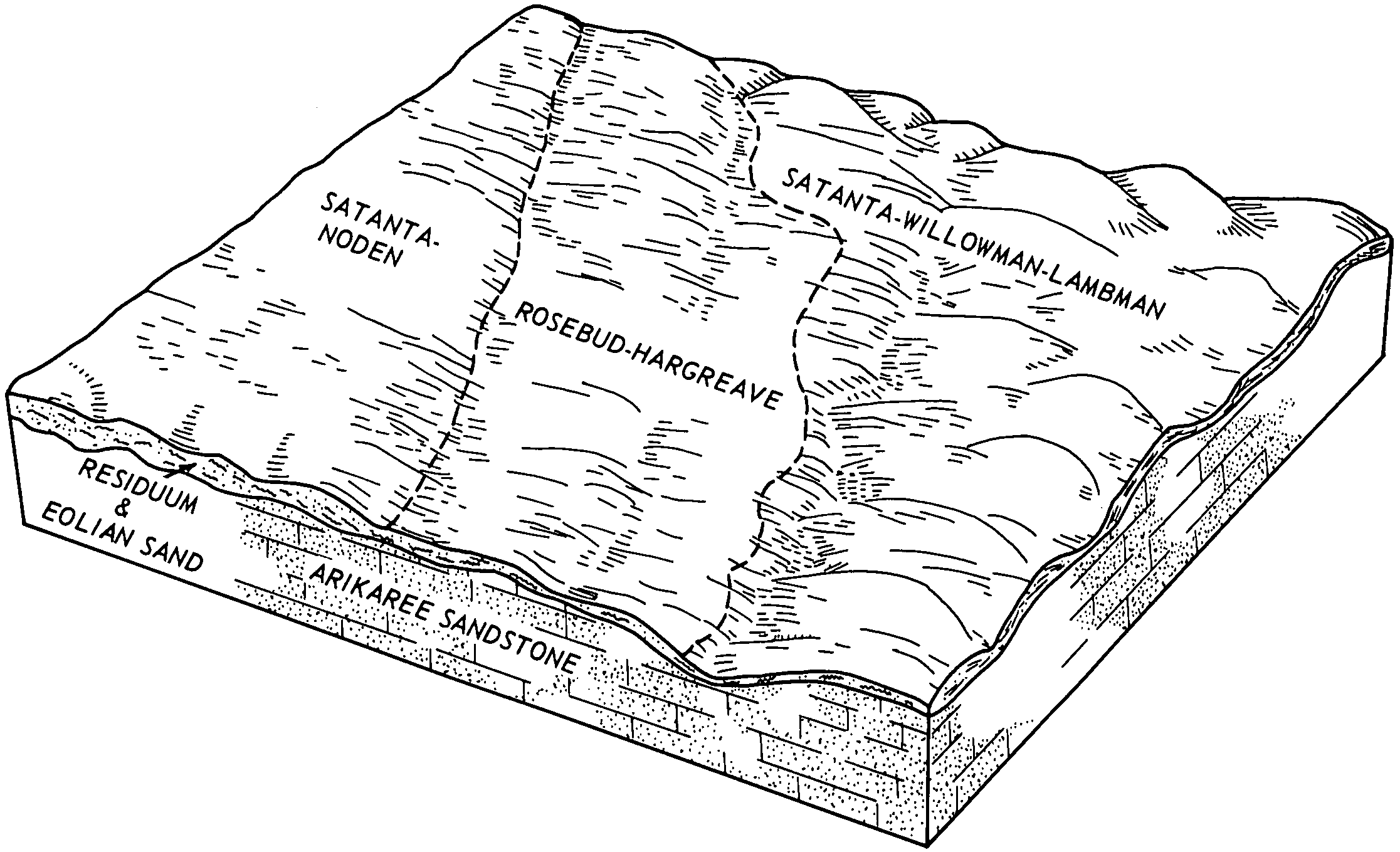
Satanta-Noden complex, 0 to 6 percent slopes | 26B | 18537 | 104874 | 3j41 | wy715 | 1974 | 1:20000 |
Satanta-Willowman-Lambman complex, 3 to 20 percent slopes | 27D | 10787 | 104876 | 3j43 | wy715 | 1974 | 1:20000 |
Satanta-Noden complex, 6 to 10 percent slopes | 26C | 2654 | 104875 | 3j42 | wy715 | 1974 | 1:20000 |