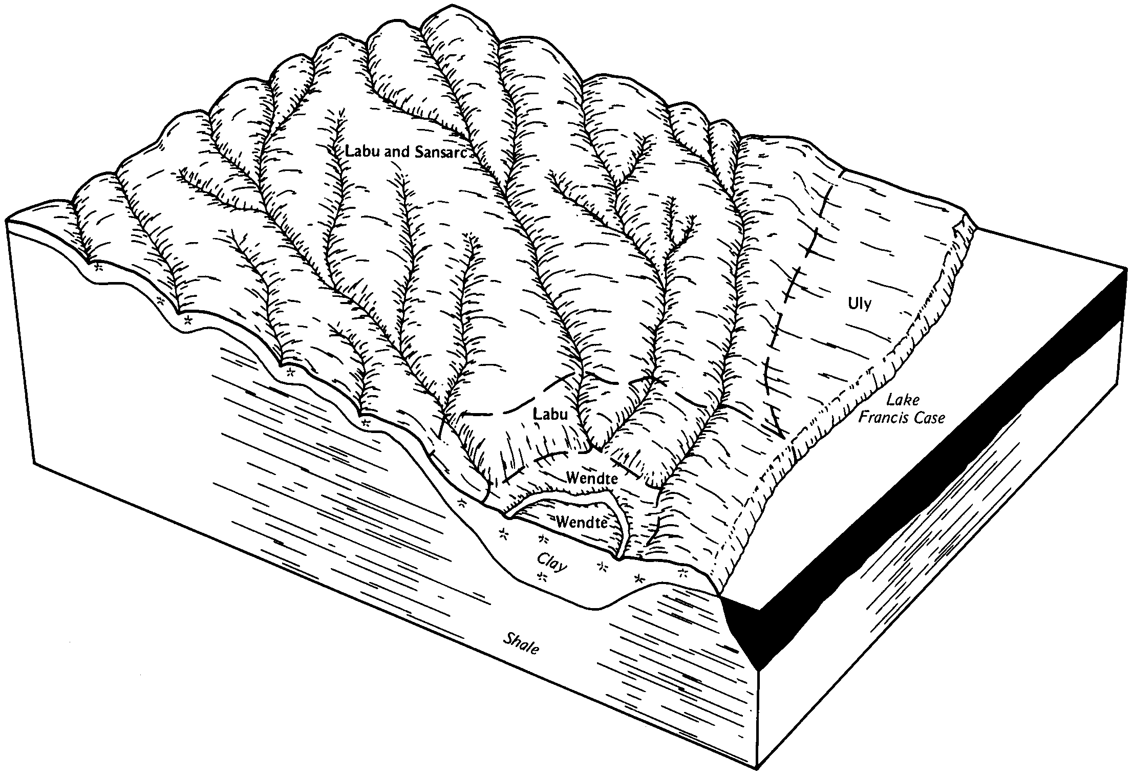
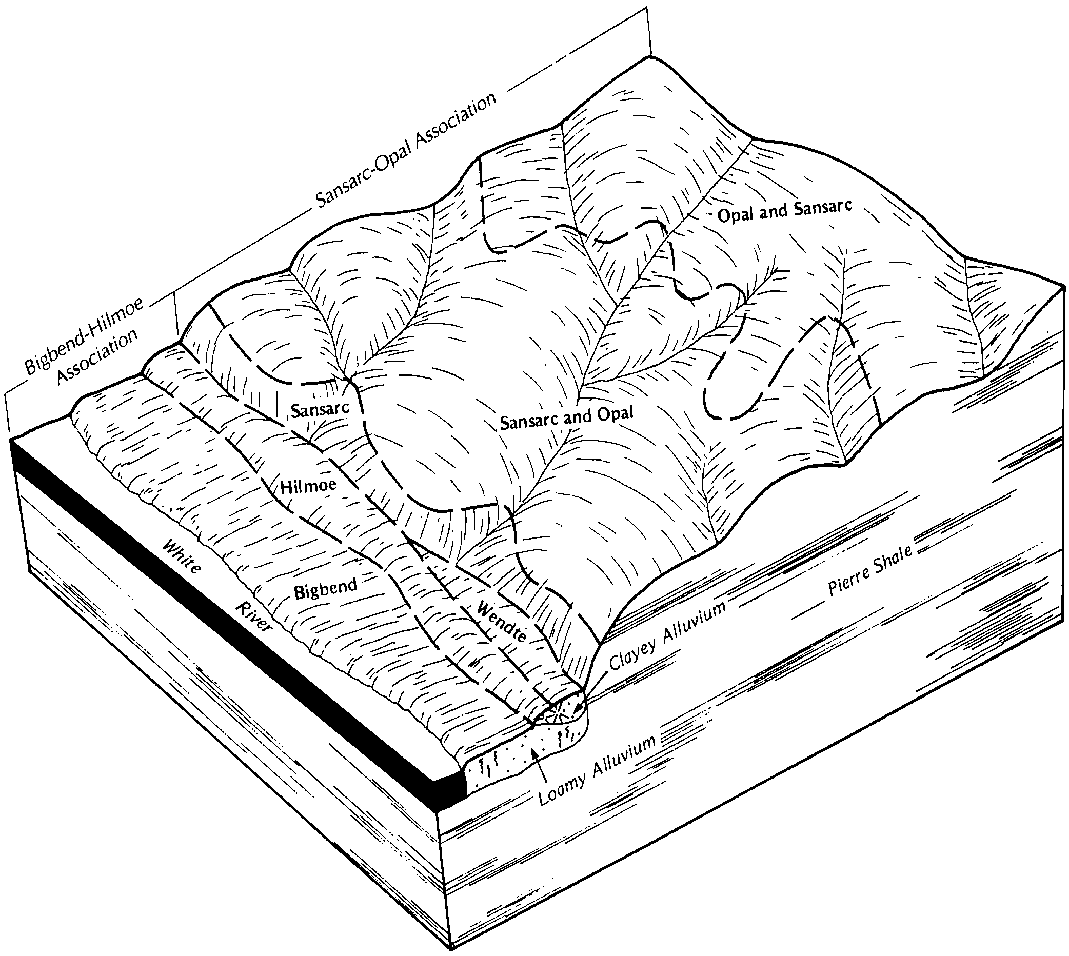
| Labu-Sansarc silty clays, 9 to 35 percent slopes | 3225 | 52082 | 357637 | 2wfq7 | ne015 | 1976 | 1:20000 |
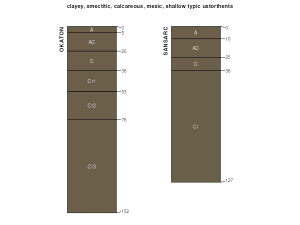
Sansarc silty clay, 9 to 35 percent slopes | 3320 | 8869 | 357665 | 2wfq6 | ne015 | 1976 | 1:20000 |
Labu-Sansarc silty clays, 9 to 35 percent slopes | 3225 | 623 | 2912585 | 2wfq7 | ne017 | 1987 | 1:20000 |
Sansarc-Nora complex, 11 to 30 percent slopes | 3322 | 535 | 426767 | gb2p | ne043 | 1972 | 1:20000 |
Labu-Sansarc silty clays, 9 to 35 percent slopes | 3225 | 19907 | 100116 | 2wfq7 | ne089 | 1981 | 1:20000 |
Sansarc silty clay, 9 to 35 percent slopes | 3320 | 2442 | 100154 | 2wfq6 | ne089 | 1981 | 1:20000 |
Labu-Sansarc silty clays, 9 to 35 percent slopes | 3225 | 18946 | 357704 | 2wfq7 | ne103 | 1977 | 1:20000 |
Sansarc silty clay, 9 to 35 percent slopes | 3320 | 6360 | 357733 | 2wfq6 | ne103 | 1977 | 1:20000 |
Labu-Sansarc silty clays, 9 to 35 percent slopes | 3225 | 39259 | 2912602 | 2wfq7 | ne107 | 1989 | 1:20000 |
Sansarc silty clay, 9 to 35 percent slopes | 3320 | 912 | 2912603 | 2wfq6 | ne107 | 1989 | 1:20000 |
Labu-Sansarc silty clays, 9 to 35 percent slopes | 3225 | 5590 | 2912604 | 2wfq7 | ne149 | 1982 | 1:20000 |
Boyd-Sansarc clays, 15 to 40 percent slopes | BsE | 4698 | 418251 | g16z | sd009 | 1981 | 1:20000 |
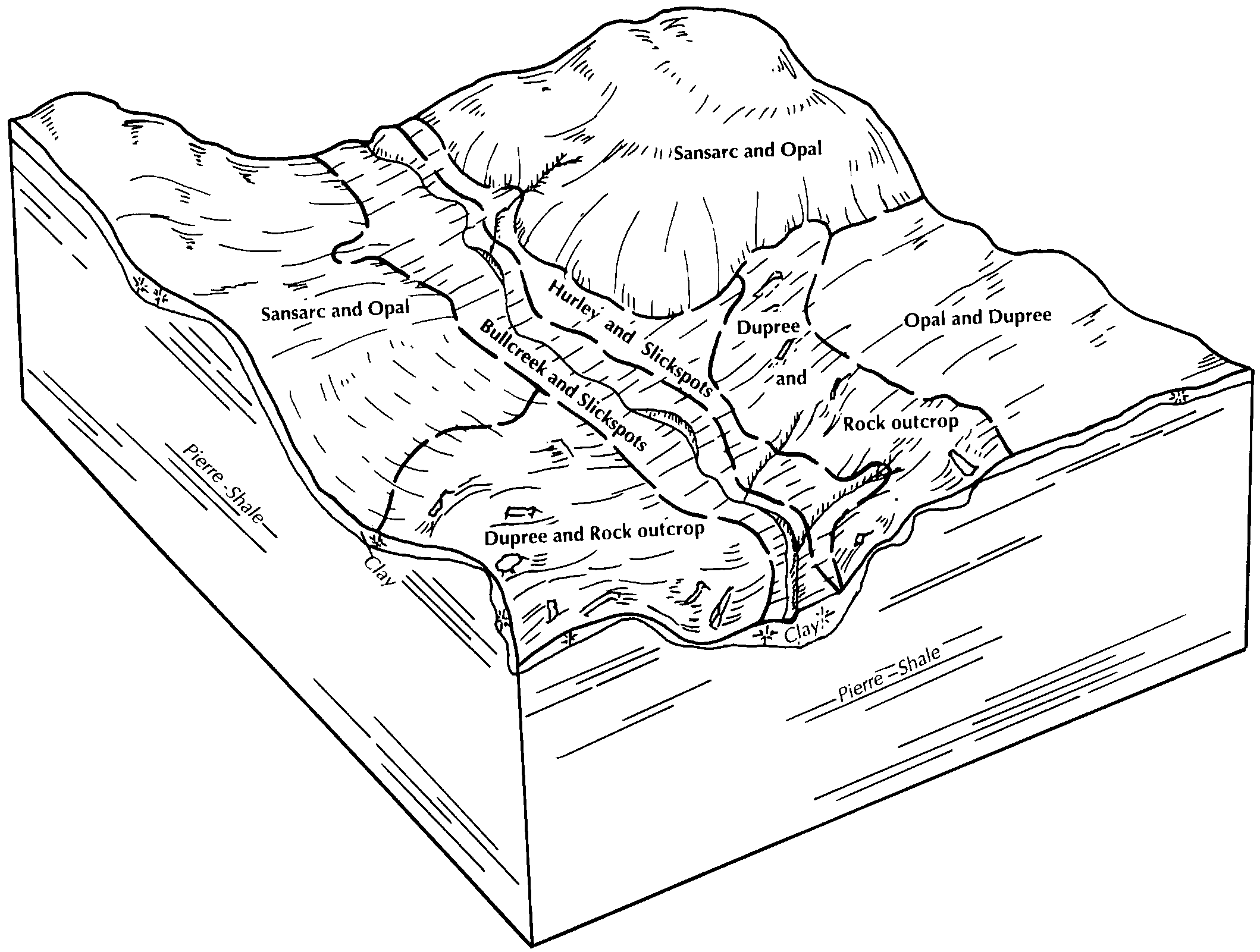
Sansarc-Opal clays, 9 to 25 percent slopes | 39E | 18447 | 354709 | 2v670 | sd021 | 1978 | 1:20000 |
Opal-Sansarc silty clays, very stony, 6 to 15 percent slopes | 40D | 7546 | 354713 | 31crg | sd021 | 1978 | 1:20000 |
Opal-Sansarc clays, cool, 6 to 15 percent slopes | C942D | 687 | 2797946 | 2rsr7 | sd021 | 1978 | 1:20000 |
Sansarc-Opal clays, cool, 15 to 40 percent slopes | C943E | 337 | 2797947 | 2rsr8 | sd021 | 1978 | 1:20000 |
Sansarc-Boyd complex, 6 to 35 percent slopes | SoF | 32348 | 355069 | 2zr0d | sd023 | 1980 | 1:20000 |
Sansarc clay, 6 to 35 percent slopes | SnF | 8546 | 355068 | 2v675 | sd023 | 1980 | 1:20000 |
Boyd-Sansarc complex, 6 to 15 percent slopes | BsD | 6309 | 355009 | cxdx | sd023 | 1980 | 1:20000 |
Sansarc-Badland complex, 9 to 40 percent slopes | SrF | 703 | 355070 | 2wfqc | sd023 | 1980 | 1:20000 |
Gavins-Sansarc complex, 15 to 25 percent slopes | GsE | 414 | 355027 | cxfh | sd023 | 1980 | 1:20000 |
Sansarc-Opal-Dupree clays, 9 to 25% slopes | SdD | 30698 | 356208 | 2v673 | sd031 | 1986 | 1:24000 |
Sansarc-Opal clays, 9 to 25 percent slopes | SbE | 24674 | 356207 | 2v670 | sd031 | 1986 | 1:24000 |
Opal-Sansarc clays, 6 to 15 percent slopes | OsC | 10315 | 356185 | 2v671 | sd031 | 1986 | 1:24000 |
Sansarc-Wabek complex, 15 to 40 percent slopes | SeE | 4082 | 356209 | cynm | sd031 | 1986 | 1:24000 |
Sansarc-Opal clays, 9 to 25 percent slopes | SbE | 345093 | 2739007 | 2v670 | sd041 | 1972 | 1:24000 |
Sansarc-Dupree, acid, clays, 6 to 25 percent slopes | R511E | 82140 | 2649231 | 2r97y | sd041 | 1972 | 1:24000 |
Opal-Sansarc clays, 6 to 15 percent slopes | OsC | 77630 | 354217 | 2v671 | sd041 | 1972 | 1:24000 |
Dupree-Sansarc clays, 9 to 25 percent slopes | DsE | 13082 | 354187 | cwkd | sd041 | 1972 | 1:24000 |
Schamber-Sansarc complex, 6 to 40 percent slopes | SwF | 11393 | 354241 | 2zk3x | sd041 | 1972 | 1:24000 |
Sansarc-Badland complex, 9 to 40 percent slopes | ScF | 9922 | 354239 | 2wfqc | sd041 | 1972 | 1:24000 |
Sansarc-Opal clays, 6 to 15 percent slopes | SbC | 8297 | 3331085 | 31crj | sd041 | 1972 | 1:24000 |
Sansarc-Dupree clays, 9 to 45 percent slopes | SaE | 3723 | 354236 | cwlz | sd041 | 1972 | 1:24000 |
Labu-Sansarc silty clays, 9 to 35 percent slopes | LcF | 126292 | 355254 | 2wfq7 | sd053 | 1982 | 1:20000 |
Sansarc-Opal clays, 9 to 25 percent slopes | S502E | 2898 | 2615641 | 2v670 | sd053 | 1982 | 1:20000 |
Sansarc-Badland complex, 9 to 40 percent slopes | ScE | 1321 | 355293 | 2wfqc | sd053 | 1982 | 1:20000 |
Rock outcrop-Sansarc-Opal complex, 6 to 40 percent slopes | RpE | 70 | 2615642 | 2rmj2 | sd053 | 1982 | 1:20000 |
Opal-Sansarc clays, 6 to 15 percent slopes | OsD | 20239 | 2652521 | 2v671 | sd055 | 1992 | 1:24000 |
Sansarc-Opal clays, 9 to 25 percent slopes | SoE | 14195 | 2739009 | 2v670 | sd055 | 1992 | 1:24000 |
Wendte, channeled-Sansarc complex, 0 to 60 percent slopes | WsE | 5148 | 354168 | cwjs | sd055 | 1992 | 1:24000 |
Sansarc-Dupree, acid, clays, 6 to 25 percent slopes | R511E | 2517 | 2649234 | 2r97y | sd055 | 1992 | 1:24000 |
Sansarc-Opal clays, 9 to 25 percent slopes | LtD | 1105 | 352643 | 2v670 | sd059 | 1959 | 1:20000 |
Opal-Sansarc clays, 6 to 15 percent slopes | OuD | 8 | 3331100 | 2v671 | sd059 | 1959 | 1:20000 |
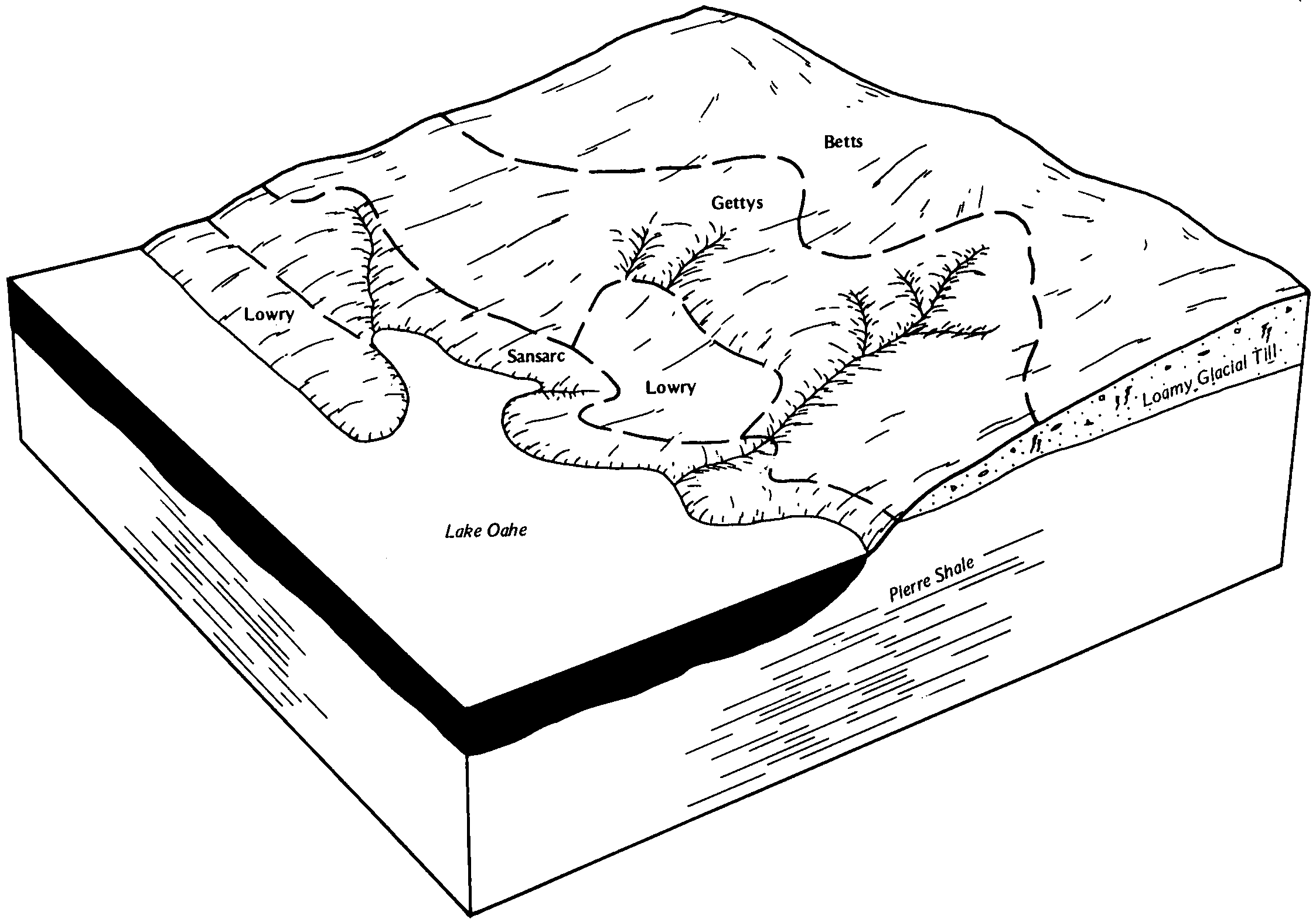
Sansarc-Lakoma clays, 9 to 40 percent slopes | ScE | 10786 | 353330 | cvnr | sd065 | 1970 | 1:20000 |
Sansarc-Badland complex, 9 to 40 percent slopes | Sd | 7136 | 353331 | 2wfqc | sd065 | 1970 | 1:20000 |
Sansarc-Gettys complex, 9 to 34 percent slopes | SaE | 2722 | 353329 | cvnq | sd065 | 1970 | 1:20000 |
Sansarc-Opal clays, 9 to 25 percent slopes | SbF | 11122 | 353847 | 2v670 | sd069 | 1992 | 1:20000 |
Opal-Sansarc silty clays, very stony, 6 to 15 percent slopes | OuD | 6725 | 353831 | 31crg | sd069 | 1992 | 1:20000 |
Gettys-Sansarc complex, 9 to 40 percent slopes | GfF | 2961 | 353796 | cw4s | sd069 | 1992 | 1:20000 |
Rock outcrop-Sansarc complex, 6 to 40 percent slopes | RsF | 2426 | 353846 | 2ynv1 | sd069 | 1992 | 1:20000 |
Opal-Sansarc clays, 6 to 15 percent slopes | OsD | 42834 | 2652522 | 2v671 | sd075 | 1991 | 1:24000 |
Sansarc-Opal clays, 9 to 25 percent slopes | SoE | 23505 | 2739010 | 2v670 | sd075 | 1991 | 1:24000 |
Sansarc-Dupree, acid, clays, 6 to 25 percent slopes | R511E | 7948 | 2649235 | 2r97y | sd075 | 1991 | 1:24000 |
Sansarc-Vivian complex, 9 to 40 percent slopes | SvE | 3120 | 353680 | cw11 | sd075 | 1991 | 1:24000 |
Sansarc-Badland complex, 9 to 40 percent slopes | SrE | 1608 | 353679 | 2wfqc | sd075 | 1991 | 1:24000 |
Sansarc-Opal clays, 9 to 25 percent slopes | SbE | 123558 | 2739011 | 2v670 | sd085 | 1984 | 1:20000 |
Opal-Sansarc clays, 6 to 15 percent slopes | OnD | 101250 | 355603 | 2v671 | sd085 | 1984 | 1:20000 |
Sansarc-Opal-Promise clays, 6 to 35 percent slopes | SpE | 31500 | 2615644 | 2rmj4 | sd085 | 1984 | 1:20000 |
Rock outcrop-Sansarc-Opal complex, 6 to 40 percent slopes | RpE | 24818 | 2615646 | 2rmj2 | sd085 | 1984 | 1:20000 |
Sansarc-Badland complex, 9 to 40 percent slopes | ScE | 9748 | 355620 | 2wfqc | sd085 | 1984 | 1:20000 |
Rock outcrop-Sansarc complex, 6 to 40 percent slopes | RsF | 6051 | 355617 | 2ynv1 | sd085 | 1984 | 1:20000 |
Sansarc-Opal-Schamber complex, 6 to 30 percent slopes | SoE | 3096 | 2615643 | 2rmj5 | sd085 | 1984 | 1:20000 |
Sansarc-Schamber complex, 9 to 35 percent slopes | SeE | 586 | 355621 | 2wfq9 | sd085 | 1984 | 1:20000 |
Sansarc-Schamber complex, 9 to 35 percent slopes | SnE | 26727 | 353438 | 2wfq9 | sd095 | 1971 | 1:20000 |
Schamber-Sansarc complex, 6 to 40 percent slopes | SwF | 9938 | 353445 | 2zk3x | sd095 | 1971 | 1:20000 |
Sansarc-Manter complex, 15 to 40 percent slopes | SmE | 6674 | 353437 | cvs6 | sd095 | 1971 | 1:20000 |
Sansarc-Badland complex, 9 to 40 percent slopes | Ss | 5257 | 353439 | 2wfqc | sd095 | 1971 | 1:20000 |
Manter-Sansarc complex, 9 to 25 percent slopes | McE | 2475 | 353396 | cvqw | sd095 | 1971 | 1:20000 |
Sansarc-Opal clays, 9 to 25 percent slopes | S502E | 1362 | 2615648 | 2v670 | sd095 | 1971 | 1:20000 |
Rock outcrop-Sansarc-Opal complex, 6 to 40 percent slopes | RpE | 308 | 2615649 | 2rmj2 | sd095 | 1971 | 1:20000 |
Sansarc-Opal clays, 9 to 25 percent slopes | SbE | 17291 | 355372 | 2v670 | sd107 | 1983 | 1:20000 |
Opal-Sansarc silty clays, very stony, 6 to 15 percent slopes | OsD | 7154 | 355357 | 31crg | sd107 | 1983 | 1:20000 |
Sansarc-Opal-Dupree, acid, clays, 6 to 25 percent slopes | R510E | 157 | 2482452 | 2v674 | sd107 | 1983 | 1:20000 |
Sansarc-Dupree, acid, clays, 6 to 25 percent slopes | R511E | 149440 | 2649237 | 2r97y | sd117 | 1977 | 1:24000 |
Sansarc-Opal clays, 6 to 15 percent slopes | ScD | 89325 | 3331093 | 31crj | sd117 | 1977 | 1:24000 |
Sansarc-Opal clays, 9 to 25 percent slopes | SoE | 75986 | 2739013 | 2v670 | sd117 | 1977 | 1:24000 |
Sansarc-Badland complex, 9 to 40 percent slopes | Sd | 50931 | 353514 | 2wfqc | sd117 | 1977 | 1:24000 |
Chantier-Sansarc clays, 3 to 15 percent slopes | CsD | 24624 | 353469 | 2yntf | sd117 | 1977 | 1:24000 |
Opal-Sansarc clays, 6 to 15 percent slopes | OsD | 7274 | 1015963 | 2v671 | sd117 | 1977 | 1:24000 |
Rock outcrop-Sansarc complex, 6 to 40 percent slopes | RsF | 6791 | 353510 | 2ynv1 | sd117 | 1977 | 1:24000 |
Sully-Sansarc complex, 9 to 25 percent slopes | SvE | 990 | 353521 | cvvx | sd117 | 1977 | 1:24000 |
Sansarc-Opal-Dupree, acid, clays, 6 to 25 percent slopes | R510E | 11047 | 2739020 | 2v674 | sd119 | 1967 | 1:20000 |
Boyd-Sansarc clays, 6 to 19 percent slopes | BsD | 2133 | 352979 | cv9f | sd121 | 1967 | 1:31680 |
Sansarc-Boyd clays, 9 to 35 percent slopes | SbE | 838 | 353034 | 2ynv5 | sd121 | 1967 | 1:31680 |
Sansarc-Opal clays, 9 to 25 percent slopes | S502E | 40982 | 2615651 | 2v670 | sd123 | 1975 | 1:20000 |
Opal-Sansarc clays, 6 to 15 percent slopes | OsE | 6384 | 354424 | 2v671 | sd123 | 1975 | 1:20000 |
Rock outcrop-Sansarc-Opal complex, 6 to 40 percent slopes | RpE | 1410 | 2615650 | 2rmj2 | sd123 | 1975 | 1:20000 |
Sansarc-Opal clays, 9 to 25 percent slopes | SaE | 17503 | 354525 | 2v670 | sd129 | 1975 | 1:20000 |
Opal-Sansarc silty clays, very stony, 6 to 15 percent slopes | OsD | 14696 | 354515 | 31crg | sd129 | 1975 | 1:20000 |
Sansarc-Opal clays, 9 to 25 percent slopes | R507E | 74745 | 2649230 | 2v670 | sd137 | 1985 | 1:24000 |
Sansarc-Dupree, acid, clays, 6 to 25 percent slopes | R511E | 35 | 2649232 | 2r97y | sd137 | 1985 | 1:24000 |
Opal-Sansarc clays, 6 to 15 percent slopes | OsC | 22 | 3331105 | 2v671 | sd137 | 1985 | 1:24000 |
Sansarc-Opal clays, 9 to 25 percent slopes | SaE | 52167 | 2739016 | 2v670 | sd603 | 1983 | 1:20000 |
Chantier-Sansarc clays, 3 to 15 percent slopes | CsD | 17325 | 355492 | 2yntf | sd603 | 1983 | 1:20000 |
Rock outcrop-Sansarc complex, 6 to 40 percent slopes | RsF | 7716 | 355542 | 2ynv1 | sd603 | 1983 | 1:20000 |
Opal-Sansarc clays, 6 to 15 percent slopes | OsD | 5157 | 3331098 | 2v671 | sd611 | 2011 | 1:24000 |


