| Daglum-Rhoades complex, 0 to 6 percent slopes | E0454B | 1418 | 342231 | 2r4g8 | mt025 | 1991 | 1:24000 |
Rhoades-Daglum complex, 0 to 6 percent slopes | E0515B | 360 | 3256659 | 2r4gb | mt025 | 1991 | 1:24000 |
Rhoades-Moline complex, 8 to 11 percent slopes | Re | 5512 | 345652 | clp2 | mt109 | 1956 | 1:31680 |
Rhoades clay loam, 4 to 7 percent slopes | Rd | 2438 | 345651 | clp1 | mt109 | 1956 | 1:31680 |
Rhoades-Moline complex, 12 to 20 percent slopes | Rg | 1979 | 345653 | clp3 | mt109 | 1956 | 1:31680 |
Rhoades complex | Ro | 18281 | 146917 | 4xw8 | mt600 | 1969 | 1:24000 |
Wyola-Rhoades clay loams, 0 to 4 percent slopes | Se | 5129 | 146930 | 4xwp | mt600 | 1969 | 1:24000 |
Rhoades-Arvada complex | Ro | 4044 | 147409 | 4yd4 | mt602 | 1963 | 1:20000 |
Winifred-Rhoades clay loams | Wm | 2824 | 147462 | 4yfv | mt602 | 1963 | 1:20000 |
Rhoades-Daglum complex, 0 to 6 percent slopes | E0515B | 25934 | 2525720 | 2r4gb | nd001 | 1983 | 1:20000 |
Rhoades-Rhoades, severely eroded complex, 0 to 6 percent slopes | E0531B | 185 | 2755633 | 2r4gg | nd001 | 1983 | 1:20000 |
Daglum-Rhoades complex, 0 to 6 percent slopes | E0454B | 60 | 2755632 | 2r4g8 | nd001 | 1983 | 1:20000 |
Korell-Rhoades-Daglum complex, 0 to 2 percent slopes, rarely flooded | E4181A | 54 | 2755661 | 1vzw4 | nd001 | 1983 | 1:20000 |
Farnuf-Belfield-Rhoades complex, 0 to 2 percent slopes | E0627A | 38 | 2755634 | 2r4h2 | nd001 | 1983 | 1:20000 |
Daglum-Rhoades complex, 0 to 6 percent slopes | E0454B | 30865 | 2699036 | 2r4g8 | nd007 | 1998 | 1:24000 |
Rhoades-Daglum complex, 0 to 6 percent slopes | E0515B | 13463 | 2699037 | 2r4gb | nd007 | 1998 | 1:24000 |
Korell-Rhoades-Daglum complex, 0 to 2 percent slopes, rarely flooded | E4181A | 1021 | 2707107 | 1vzw4 | nd007 | 1998 | 1:24000 |
Lambert-Vanda, high precipitation-Rhoades, barren complex, 0 to 9 percent slopes | E3247C | 278 | 2707102 | 1vzvl | nd007 | 1998 | 1:24000 |
Rhoades-Daglum complex, 0 to 6 percent slopes | E0515B | 47165 | 2563602 | 2r4gb | nd011 | 1969 | 1:20000 |
Rhoades-Rhoades, severely eroded complex, 0 to 6 percent slopes | E0531B | 21345 | 2563603 | 2r4gg | nd011 | 1969 | 1:20000 |
Rhoades-Absher complex, 2 to 6 percent slopes | RrB | 16226 | 992893 | 12b5t | nd011 | 1969 | 1:20000 |
Farnuf-Belfield-Rhoades complex, 0 to 2 percent slopes | E0627A | 5550 | 2563551 | 2r4h2 | nd011 | 1969 | 1:20000 |
Rhoades-Absher complex, 0 to 2 percent slopes | RrA | 5140 | 992892 | 12b5s | nd011 | 1969 | 1:20000 |
Rhoades complex, terrace, 0 to 6 percent slopes | Rt | 4021 | 992894 | 12b5v | nd011 | 1969 | 1:20000 |
Daglum-Rhoades complex, 0 to 6 percent slopes | E0454B | 2819 | 2699397 | 2r4g8 | nd011 | 1969 | 1:20000 |
Marmarth-Rhoades complex, 3 to 6 percent slopes | MkB | 1911 | 992863 | 12b4v | nd011 | 1969 | 1:20000 |
Kremlin-Belfield-Rhoades complex, 0 to 6 percent slopes | KsA | 1710 | 992850 | 12b4f | nd011 | 1969 | 1:20000 |
Marmarth-Rhoades complex, 6 to 9 percent slopes | MkC | 825 | 992864 | 12b4w | nd011 | 1969 | 1:20000 |
Grail-Rhoades silty clay loams, 0 to 2 percent slopes | GoA | 815 | 992834 | 12b3x | nd011 | 1969 | 1:20000 |
Daglum-Rhoades loams, 0 to 2 percent slopes | DdA | 495 | 992815 | 12b39 | nd011 | 1969 | 1:20000 |
Grail-Rhoades silty clay loams, 2 to 6 percent slopes | GoB | 476 | 992835 | 12b3y | nd011 | 1969 | 1:20000 |
Marmarth-Rhoades complex, 0 to 3 percent slopes | MkA | 271 | 992862 | 12b4t | nd011 | 1969 | 1:20000 |
Wyola-Rhoades silty clay loams, 0 to 2 percent slopes | ScA | 145 | 992897 | 12b5y | nd011 | 1969 | 1:20000 |
Korell-Rhoades-Daglum complex, 0 to 2 percent slopes, rarely flooded | E4181A | 24 | 2758457 | 1vzw4 | nd011 | 1969 | 1:20000 |
Shambo-Belfield-Rhoades loams, 0 to 2 percent slopes | SmA | 11 | 992905 | 12b66 | nd011 | 1969 | 1:20000 |
Rhoades-Daglum complex, 6 to 9 percent slopes | E0515C | 2 | 2758444 | 2r4gc | nd011 | 1969 | 1:20000 |
Rhoades-Daglum complex, 0 to 2 percent slopes | C591A | 12507 | 2596812 | 2qyfv | nd015 | 1967 | 1:20000 |
Belfield-Rhoades complex, 0 to 2 percent slopes | C522A | 11126 | 2564120 | 2q2m2 | nd015 | 1967 | 1:20000 |
Belfield-Rhoades-Grail complex, 0 to 2 percent slopes | C523A | 3921 | 2564132 | 2q3b6 | nd015 | 1967 | 1:20000 |
Rhoades-Daglum complex, 6 to 9 percent slopes | E0515C | 994 | 2661736 | 2r4gc | nd015 | 1967 | 1:20000 |
Belfield-Rhoades complex, 2 to 6 percent slopes | C522B | 716 | 2564131 | 2q3b5 | nd015 | 1967 | 1:20000 |
Daglum-Rhoades complex, 0 to 6 percent slopes | E0454B | 545 | 2661734 | 2r4g8 | nd015 | 1967 | 1:20000 |
Rhoades-Daglum complex, 2 to 9 percent slopes | C591C | 472 | 2564191 | 2q77p | nd015 | 1967 | 1:20000 |
Daglum-Rhoades silt loams, 2 to 6 percent slopes | C526B | 384 | 2564175 | 2q6lz | nd015 | 1967 | 1:20000 |
Korell-Rhoades-Daglum complex, 0 to 2 percent slopes, rarely flooded | E4181A | 121 | 2661704 | 1vzw4 | nd015 | 1967 | 1:20000 |
Rhoades-Daglum complex, 0 to 6 percent slopes | E0515B | 35 | 2661735 | 2r4gb | nd015 | 1967 | 1:20000 |
Rhoades-Daglum complex, 0 to 6 percent slopes | E0515B | 61835 | 2707169 | 2r4gb | nd025 | 1981 | 1:20000 |
Daglum-Rhoades complex, 0 to 6 percent slopes | E0454B | 13561 | 2707167 | 2r4g8 | nd025 | 1981 | 1:20000 |
Farnuf-Belfield-Rhoades complex, 2 to 6 percent slopes | E0629B | 10060 | 2707176 | 2r4h4 | nd025 | 1981 | 1:20000 |
Lambert-Vanda, high precipitation-Rhoades, barren complex, 0 to 9 percent slopes | E3247C | 4979 | 2707226 | 1vzvl | nd025 | 1981 | 1:20000 |
Korell-Rhoades-Daglum complex, 0 to 2 percent slopes, rarely flooded | E4181A | 3739 | 2707247 | 1vzw4 | nd025 | 1981 | 1:20000 |
Farnuf-Belfield-Rhoades complex, 0 to 2 percent slopes | E0627A | 2722 | 2707175 | 2r4h2 | nd025 | 1981 | 1:20000 |
Daglum-Rhoades complex, 6 to 9 percent slopes | E0454C | 17957 | 2661751 | cdp5 | nd029 | 1979 | 1:20000 |
Rhoades-Daglum complex, 6 to 9 percent slopes | E0515C | 10979 | 2661827 | 2r4gc | nd029 | 1979 | 1:20000 |
Daglum-Rhoades complex, 0 to 6 percent slopes | E0454B | 10735 | 2661825 | 2r4g8 | nd029 | 1979 | 1:20000 |
Rhoades-Daglum complex, 0 to 6 percent slopes | E0515B | 3920 | 2661826 | 2r4gb | nd029 | 1979 | 1:20000 |
Rhoades-Daglum complex, 2 to 9 percent slopes | C591C | 741 | 2564364 | 2q77p | nd029 | 1979 | 1:20000 |
Daglum-Rhoades silt loams, 0 to 2 percent slopes | C526A | 705 | 2596932 | 2q6ly | nd029 | 1979 | 1:20000 |
Rhoades-Daglum complex, 0 to 2 percent slopes | C591A | 1 | 2596841 | 2qyfv | nd029 | 1979 | 1:20000 |
Rhoades-Daglum complex, 0 to 6 percent slopes | E0515B | 4824 | 2707272 | 2r4gb | nd033 | 1985 | 1:24000 |
Daglum-Rhoades complex, 0 to 6 percent slopes | E0454B | 20 | 2759729 | 2r4g8 | nd033 | 1985 | 1:24000 |
Rhoades-Daglum complex, 0 to 6 percent slopes | E0515B | 23971 | 2525857 | 2r4gb | nd037 | 1985 | 1:20000 |
Daglum-Rhoades complex, 0 to 6 percent slopes | E0454B | 22341 | 2525855 | 2r4g8 | nd037 | 1985 | 1:20000 |
Rhoades-Daglum complex, 6 to 9 percent slopes | E0515C | 20507 | 2525858 | 2r4gc | nd037 | 1985 | 1:20000 |
Daglum-Rhoades loams, saline, 0 to 2 percent slopes | E0465A | 464 | 2525856 | 2r4g9 | nd037 | 1985 | 1:20000 |
Daglum-Rhoades complex, 6 to 9 percent slopes | E0454C | 306 | 2759630 | cdp5 | nd037 | 1985 | 1:20000 |
Rhoades-Daglum-Ekalaka fine sandy loams, 0 to 9 percent slopes | E0457C | 27 | 2759631 | cdp6 | nd037 | 1985 | 1:20000 |
Daglum-Rhoades complex, 0 to 6 percent slopes | E0454B | 17023 | 2525779 | 2r4g8 | nd041 | 1986 | 1:20000 |
Daglum-Rhoades loams, saline, 0 to 2 percent slopes | E0465A | 1162 | 2755672 | 2r4g9 | nd041 | 1986 | 1:20000 |
Rhoades-Daglum complex, 0 to 6 percent slopes | E0515B | 913 | 2525776 | 2r4gb | nd041 | 1986 | 1:20000 |
Farnuf-Belfield-Rhoades complex, 0 to 2 percent slopes | E0627A | 282 | 2755674 | 2r4h2 | nd041 | 1986 | 1:20000 |
Rhoades-Daglum complex, 6 to 9 percent slopes | E0515C | 18 | 2755673 | 2r4gc | nd041 | 1986 | 1:20000 |
Rhoades-Daglum complex, 0 to 6 percent slopes | E0515B | 542 | 2661888 | 2r4gb | nd047 | 1992 | 1:20000 |
Rhoades-Daglum complex, 6 to 9 percent slopes | E0515C | 297 | 2661889 | 2r4gc | nd047 | 1992 | 1:20000 |
Rhoades-Daglum complex, 2 to 9 percent slopes | C591C | 80 | 2566539 | 2q77p | nd047 | 1992 | 1:20000 |
Rhoades-Daglum complex, 0 to 6 percent slopes | E0515B | 223 | 2662022 | 2r4gb | nd051 | 1992 | 1:24000 |
Rhoades-Daglum complex, 6 to 9 percent slopes | E0515C | 181 | 2662023 | 2r4gc | nd051 | 1992 | 1:24000 |
Rhoades-Daglum complex, 2 to 9 percent slopes | C591C | 128 | 2566625 | 2q77p | nd051 | 1992 | 1:24000 |
Daglum-Rhoades complex, 0 to 6 percent slopes | E0454B | 4 | 2662021 | 2r4g8 | nd051 | 1992 | 1:24000 |
Rhoades-Daglum complex, 0 to 6 percent slopes | E0515B | 27043 | 2715032 | 2r4gb | nd053 | 2003 | 1:24000 |
Lambert-Vanda, high precipitation-Rhoades, barren complex, 0 to 9 percent slopes | E3247C | 3502 | 2715102 | 1vzvl | nd053 | 2003 | 1:24000 |
Daglum-Rhoades complex, 0 to 6 percent slopes | E0454B | 128 | 2759710 | 2r4g8 | nd053 | 2003 | 1:24000 |
Rhoades-Daglum complex, 6 to 9 percent slopes | E0515C | 1027 | 2662492 | 2r4gc | nd055 | 1974 | 1:20000 |
Rhoades-Daglum complex, 2 to 9 percent slopes | C591C | 895 | 2566724 | 2q77p | nd055 | 1974 | 1:20000 |
Rhoades-Daglum complex, 0 to 6 percent slopes | E0515B | 273 | 2662491 | 2r4gb | nd055 | 1974 | 1:20000 |
Rhoades-Daglum complex, 6 to 9 percent slopes | E0515C | 21988 | 2699309 | 2r4gc | nd057 | 1976 | 1:20000 |
Rhoades-Daglum complex, 0 to 6 percent slopes | E0515B | 7717 | 2699308 | 2r4gb | nd057 | 1976 | 1:20000 |
Lambert-Vanda, high precipitation-Rhoades, barren complex, 0 to 9 percent slopes | E3247C | 2142 | 2699276 | 1vzvl | nd057 | 1976 | 1:20000 |
Daglum-Rhoades complex, 0 to 6 percent slopes | E0454B | 64 | 2755720 | 2r4g8 | nd057 | 1976 | 1:20000 |
Daglum-Rhoades complex, 6 to 9 percent slopes | E0454C | 35 | 2755721 | cdp5 | nd057 | 1976 | 1:20000 |
Korell-Rhoades-Daglum complex, 0 to 2 percent slopes, rarely flooded | E4181A | 10 | 1715107 | 1vzw4 | nd057 | 1976 | 1:20000 |
Daglum-Rhoades complex, 0 to 6 percent slopes | E0454B | 54905 | 2699158 | 2r4g8 | nd059 | 1998 | 1:20000 |
Daglum-Rhoades complex, 6 to 9 percent slopes | E0454C | 27793 | 2699159 | cdp5 | nd059 | 1998 | 1:20000 |
Rhoades-Daglum-Rhoades, severely eroded complex, 0 to 9 percent slopes | E0541C | 13084 | 2699203 | d1xx | nd059 | 1998 | 1:20000 |
Rhoades-Daglum-Ekalaka fine sandy loams, 0 to 9 percent slopes | E0457C | 4412 | 2699202 | cdp6 | nd059 | 1998 | 1:20000 |
Rhoades-Daglum complex, 0 to 6 percent slopes | E0515B | 880 | 2699201 | 2r4gb | nd059 | 1998 | 1:20000 |
Korell-Rhoades-Daglum complex, 0 to 2 percent slopes, rarely flooded | E4181A | 44 | 1718360 | 1vzw4 | nd059 | 1998 | 1:20000 |
Rhoades-Wyola complex, 0 to 6 percent slopes | C592B | 938 | 2566777 | 2q77q | nd061 | 1988 | 1:24000 |
Daglum-Rhoades silt loams, 2 to 6 percent slopes | C526B | 6 | 2567104 | 2q6lz | nd061 | 1988 | 1:24000 |
Rhoades-Daglum complex, 6 to 9 percent slopes | E0515C | 5187 | 2525903 | 2r4gc | nd065 | 1971 | 1:20000 |
Rhoades-Daglum complex, 0 to 6 percent slopes | E0515B | 4784 | 2525902 | 2r4gb | nd065 | 1971 | 1:20000 |
Daglum-Rhoades complex, 0 to 6 percent slopes | E0454B | 3433 | 2525901 | 2r4g8 | nd065 | 1971 | 1:20000 |
Rhoades-Daglum-Rhoades, severely eroded complex, 0 to 9 percent slopes | E0541C | 4 | 2755702 | d1xx | nd065 | 1971 | 1:20000 |
Korell-Rhoades-Daglum complex, 0 to 2 percent slopes, rarely flooded | E4181A | 4 | 2755717 | 1vzw4 | nd065 | 1971 | 1:20000 |
Daglum-Rhoades complex, 0 to 6 percent slopes | E0454B | 29566 | 2699076 | 2r4g8 | nd085 | 1992 | 1:24000 |
Rhoades-Daglum-Rhoades, severely eroded complex, 0 to 9 percent slopes | E0541C | 14973 | 2699125 | d1xx | nd085 | 1992 | 1:24000 |
Rhoades-Rhoades, severely eroded complex, 0 to 6 percent slopes | E0531B | 1237 | 2699124 | 2r4gg | nd085 | 1992 | 1:24000 |
Rhoades-Daglum complex, 0 to 6 percent slopes | E0515B | 217 | 2759696 | 2r4gb | nd085 | 1992 | 1:24000 |
Rhoades-Slickspots-Daglum complex, 0 to 9 percent slopes | 2327 | 109 | 337829 | cbjq | nd085 | 1992 | 1:24000 |
Korell-Rhoades-Daglum complex, 0 to 2 percent slopes, rarely flooded | E4181A | 52 | 2759706 | 1vzw4 | nd085 | 1992 | 1:24000 |
Rhoades-Daglum complex, 6 to 9 percent slopes | E0515C | 43 | 2759697 | 2r4gc | nd085 | 1992 | 1:24000 |
Daglum-Rhoades complex, 0 to 6 percent slopes | 2297 | 39 | 337799 | cbhr | nd085 | 1992 | 1:24000 |
Rhoades-Daglum complex, 0 to 6 percent slopes | E0515B | 14182 | 2707363 | 2r4gb | nd087 | 1974 | 1:20000 |
Daglum-Rhoades complex, 0 to 6 percent slopes | E0454B | 13048 | 2707361 | 2r4g8 | nd087 | 1974 | 1:20000 |
Rhoades-Rhoades, severely eroded complex, 0 to 6 percent slopes | E0531B | 8939 | 2707365 | 2r4gg | nd087 | 1974 | 1:20000 |
Farnuf-Belfield-Rhoades complex, 0 to 2 percent slopes | E0627A | 7279 | 2707370 | 2r4h2 | nd087 | 1974 | 1:20000 |
Rhoades-Daglum complex, 6 to 9 percent slopes | E0515C | 3243 | 2707364 | 2r4gc | nd087 | 1974 | 1:20000 |
Daglum-Rhoades complex, 6 to 9 percent slopes | E0454C | 2769 | 2707362 | cdp5 | nd087 | 1974 | 1:20000 |
Farnuf-Belfield-Rhoades complex, 2 to 6 percent slopes | E0629B | 2178 | 2707371 | 2r4h4 | nd087 | 1974 | 1:20000 |
Lambert-Vanda, high precipitation-Rhoades, barren complex, 0 to 9 percent slopes | E3247C | 458 | 2715855 | 1vzvl | nd087 | 1974 | 1:20000 |
Rhoades-Daglum complex, saline, 0 to 6 percent slopes | E0545B | 7 | 2699408 | 2s2nj | nd087 | 1974 | 1:20000 |
Daglum-Rhoades complex, 0 to 6 percent slopes | E0454B | 31955 | 2715967 | 2r4g8 | nd089 | 1965 | 1:20000 |
Rhoades-Daglum complex, 0 to 6 percent slopes | E0515B | 30625 | 2715968 | 2r4gb | nd089 | 1965 | 1:20000 |
Korell-Rhoades-Daglum complex, 0 to 2 percent slopes, rarely flooded | E4181A | 5025 | 2716015 | 1vzw4 | nd089 | 1965 | 1:20000 |
Lambert-Vanda, high precipitation-Rhoades, barren complex, 0 to 9 percent slopes | E3247C | 1026 | 2715999 | 1vzvl | nd089 | 1965 | 1:20000 |
Rhoades-Daglum complex, saline, 0 to 6 percent slopes | E0545B | 853 | 2699409 | 2s2nj | nd089 | 1965 | 1:20000 |
Daglum-Rhoades complex, 0 to 6 percent slopes | 2345 | 2900 | 339056 | cct9 | nd105 | 1993 | 1:24000 |
Daglum-Rhoades complex, 0 to 6 percent slopes | E0454B | 1895 | 2662598 | 2r4g8 | nd105 | 1993 | 1:24000 |
Daglum-Rhoades silt loams, 2 to 6 percent slopes | C526B | 316 | 2567040 | 2q6lz | nd105 | 1993 | 1:24000 |
Daglum-Rhoades loams, 0 to 6 percent slopes, shaly | C521B | 2357 | 2765600 | 2rrr8 | sd013 | 1987 | 1:20000 |
Rhoades-Daglum complex, 0 to 6 percent slopes | RlB | 96503 | 2876636 | 2r4gb | sd031 | 1986 | 1:24000 |
Daglum-Rhoades complex, 0 to 6 percent slopes | DaA | 38213 | 356152 | 2r4g8 | sd031 | 1986 | 1:24000 |
Rhoades-Daglum complex, 6 to 9 percent slopes | RlC | 28209 | 2933132 | 2r4gc | sd031 | 1986 | 1:24000 |
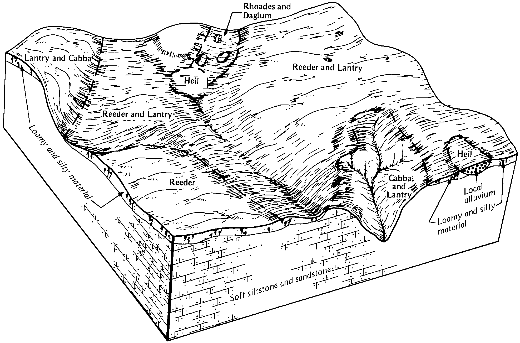
Reeder-Rhoades loams, 2 to 9 percent slopes | RhB | 25696 | 356197 | cyn7 | sd031 | 1986 | 1:24000 |
Rhoades-Daglum-Rhoades, severely eroded complex, 0 to 9 percent slopes | RtB | 18245 | 2933134 | d1xx | sd031 | 1986 | 1:24000 |
Rhoades loam, 0 to 6 percent slopes | RrA | 14396 | 356201 | cync | sd031 | 1986 | 1:24000 |
Rhoades-Slickspots-Rock outcrop complex, 0 to 40 percent slopes | RvE | 6594 | 356205 | cynh | sd031 | 1986 | 1:24000 |
Rhoades-Rhoades, severely eroded complex, 0 to 6 percent slopes | RuB | 5216 | 2876638 | 2r4gg | sd031 | 1986 | 1:24000 |
Havrelon-Rhoades loams, 0 to 4 percent slopes | HrA | 2631 | 356171 | cymd | sd031 | 1986 | 1:24000 |
Rhoades-Daglum complex, 0 to 6 percent slopes | RlB | 36770 | 2933135 | 2r4gb | sd041 | 1972 | 1:24000 |
Rhoades silt loam, 0 to 2 percent slopes | AbA | 13811 | 354171 | cwjw | sd041 | 1972 | 1:24000 |
Rhoades-Daglum complex, 6 to 9 percent slopes | RlC | 2150 | 2933136 | 2r4gc | sd041 | 1972 | 1:24000 |
Rhoades-Slickspots complex, 0 to 2 percent slopes | AcA | 1456 | 354172 | cwjx | sd041 | 1972 | 1:24000 |
Lohler, channeled-Rhoades complex | Na | 826 | 354213 | cwl7 | sd041 | 1972 | 1:24000 |
Rhoades-Daglum complex, 0 to 6 percent slopes | RnB | 47665 | 2876637 | 2r4gb | sd063 | 1984 | 1:24000 |
Rhoades-Rhoades, severely eroded complex, 0 to 6 percent slopes | RuB | 18849 | 2876639 | 2r4gg | sd063 | 1984 | 1:24000 |
Reeder-Rhoades loams, 2 to 6 percent slopes | ReB | 17907 | 355777 | cy6p | sd063 | 1984 | 1:24000 |
Amor-Rhoades loams, 6 to 9 percent slopes | AdC | 9770 | 355710 | cy4j | sd063 | 1984 | 1:24000 |
Shambo-Rhoades loams, 2 to 6 percent slopes | SmB | 4965 | 355791 | cy74 | sd063 | 1984 | 1:24000 |
Rhoades-Daglum complex, 6 to 9 percent slopes | RnC | 4445 | 2920824 | 2r4gc | sd063 | 1984 | 1:24000 |
Tanna-Rhoades complex, 2 to 9 percent slopes | ToC | 3814 | 355799 | cy7d | sd063 | 1984 | 1:24000 |
Watrous-Rhoades loams, 2 to 6 percent slopes | WbB | 317 | 355812 | cy7t | sd063 | 1984 | 1:24000 |
Rhoades-Daglum-Rhoades, severely eroded complex, 0 to 9 percent slopes | RmC | 86888 | 2933137 | d1xx | sd105 | 1977 | 1:24000 |
Reeder-Rhoades loams, 2 to 6 percent slopes | RdB | 58578 | 354650 | cx1b | sd105 | 1977 | 1:24000 |
Rhoades-Rock outcrop complex, 6 to 20 percent slopes | RnD | 32853 | 354656 | cx1j | sd105 | 1977 | 1:24000 |
Belfield-Rhoades complex, 0 to 2 percent slopes | BfA | 13706 | 354617 | cx08 | sd105 | 1977 | 1:24000 |
Morton-Rhoades loams, 6 to 15 percent slopes | MeD | 6150 | 354643 | cx13 | sd105 | 1977 | 1:24000 |
Rhoades-Daglum complex, 0 to 6 percent slopes | RlB | 54373 | 2933138 | 2r4gb | sd137 | 1985 | 1:24000 |
Regent-Rhoades complex, 2 to 9 percent slopes | RnB | 52652 | 355877 | cy9x | sd137 | 1985 | 1:24000 |
Reeder-Rhoades-Lantry complex, 2 to 9 percent slopes | ReC | 30725 | 355872 | cy9r | sd137 | 1985 | 1:24000 |
Daglum-Rhoades loams, 2 to 6 percent slopes | DrB | 27366 | 355837 | cy8m | sd137 | 1985 | 1:24000 |
Rhoades-Daglum complex, 6 to 9 percent slopes | RlC | 20776 | 2933139 | 2r4gc | sd137 | 1985 | 1:24000 |
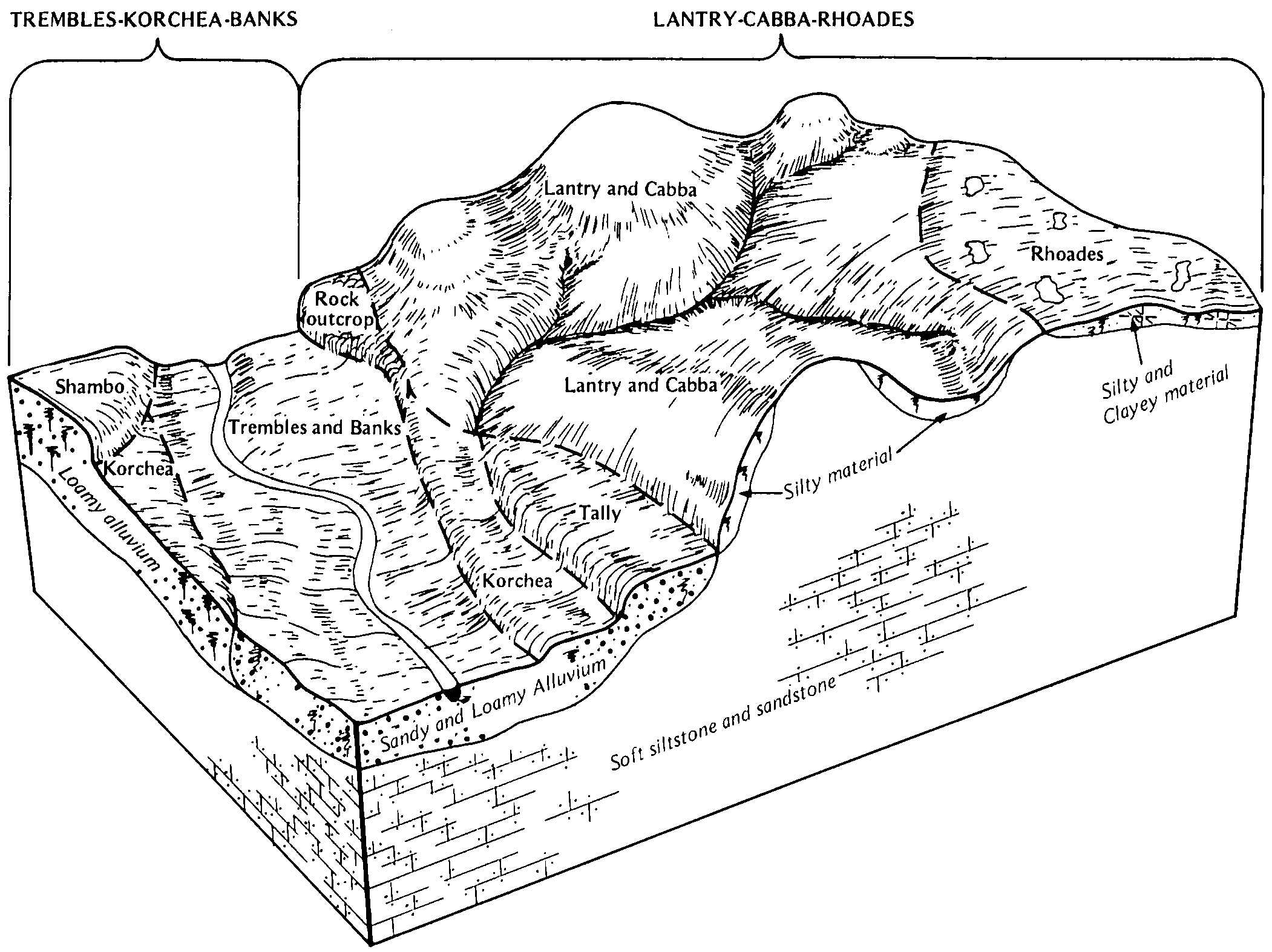
Lantry-Cabba-Rhoades complex, 9 to 30 percent slopes | LdD | 17921 | 355854 | cy95 | sd137 | 1985 | 1:24000 |
Rhoades-Slickspots complex, 1 to 6 percent slopes | RsB | 13199 | 355882 | cyb2 | sd137 | 1985 | 1:24000 |


