| Nodaway soils, frequently flooded, 0 to 2 percent slopes | 315 | 942 | 402171 | fhh8 | ia001 | 1976 | 1:15840 |
Vesser-Nodaway silt loams, 2 to 5 percent slopes | 13B | 891 | 402146 | 2y69s | ia001 | 1976 | 1:15840 |
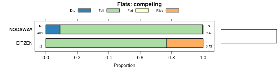
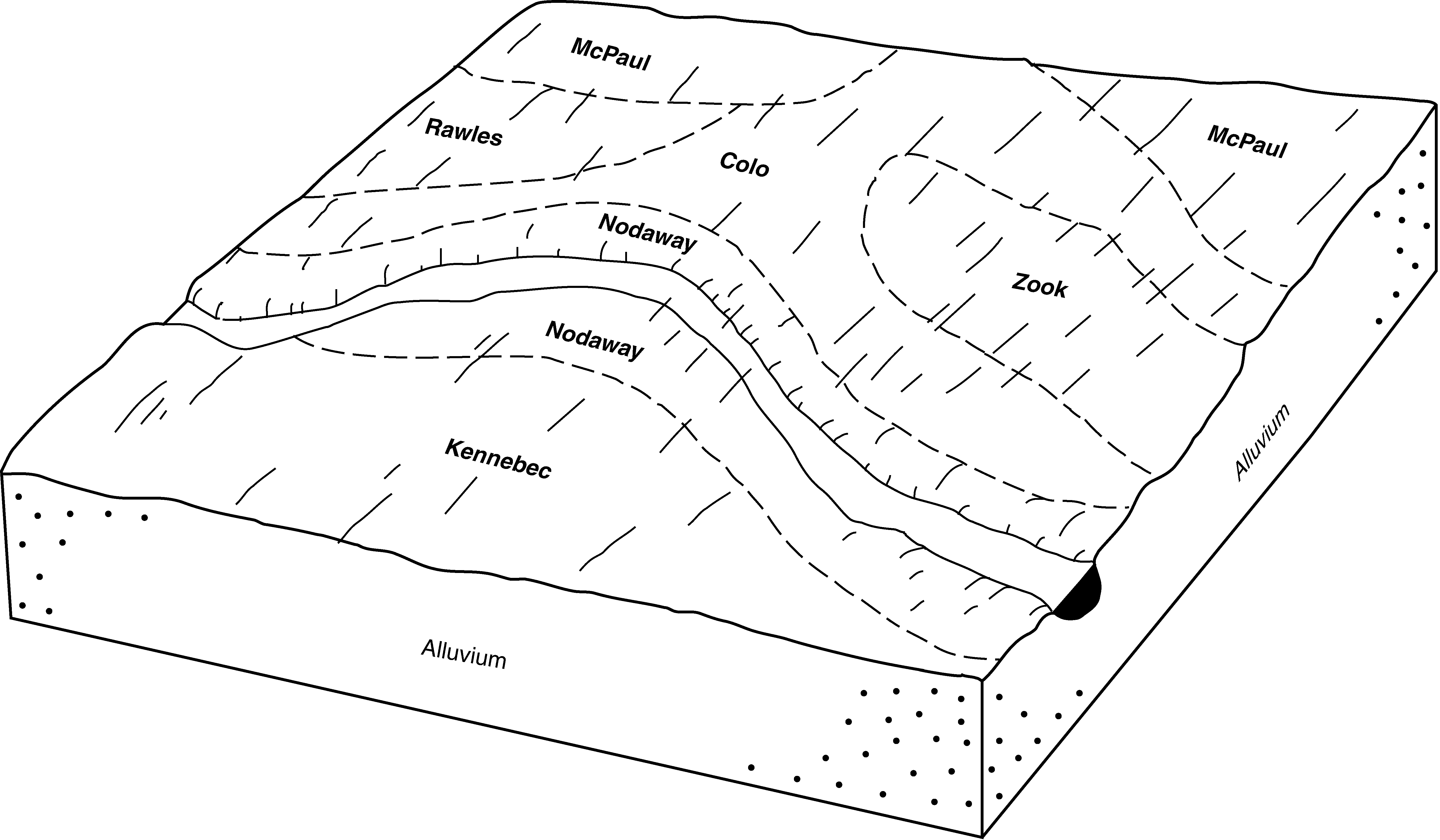
Nodaway-Kennebec complex, 0 to 2 percent slopes, occasionally flooded | 16 | 1175 | 1913136 | 226s2 | ia003 | 2008 | 1:12000 |
Nodaway silt loam | 220 | 1701 | 402659 | fj00 | ia007 | 1970 | 1:15840 |
Nodaway-Alluvial land complex | 315 | 1038 | 402678 | fj0m | ia007 | 1970 | 1:15840 |
Nodaway-Radford silt loams, 2 to 5 percent slopes | 729B | 2345 | 402914 | fj87 | ia011 | 1977 | 1:15840 |
Nodaway silt loam, shallow loess, 0 to 2 percent slopes, frequently flooded | 220 | 778 | 402861 | 2wm7x | ia011 | 1977 | 1:15840 |
Nodaway-Kennebec complex, 0 to 2 percent slopes, occasionally flooded | 16 | 4138 | 2422998 | 2mbb7 | ia029 | 2010 | 1:12000 |
Ackmore-Nodaway complex, 2 to 5 percent slopes | 729B | 4751 | 1902236 | 21vfg | ia031 | 2008 | 1:12000 |
Nodaway silt loam, 0 to 2 percent slopes, occasionally flooded | 220 | 1341 | 1397097 | 1hwsn | ia031 | 2008 | 1:12000 |
Nodaway silt loam, shallow loess, 0 to 2 percent slopes, channeled, frequently flooded | 1220 | 1173 | 1397067 | 2wm7w | ia031 | 2008 | 1:12000 |
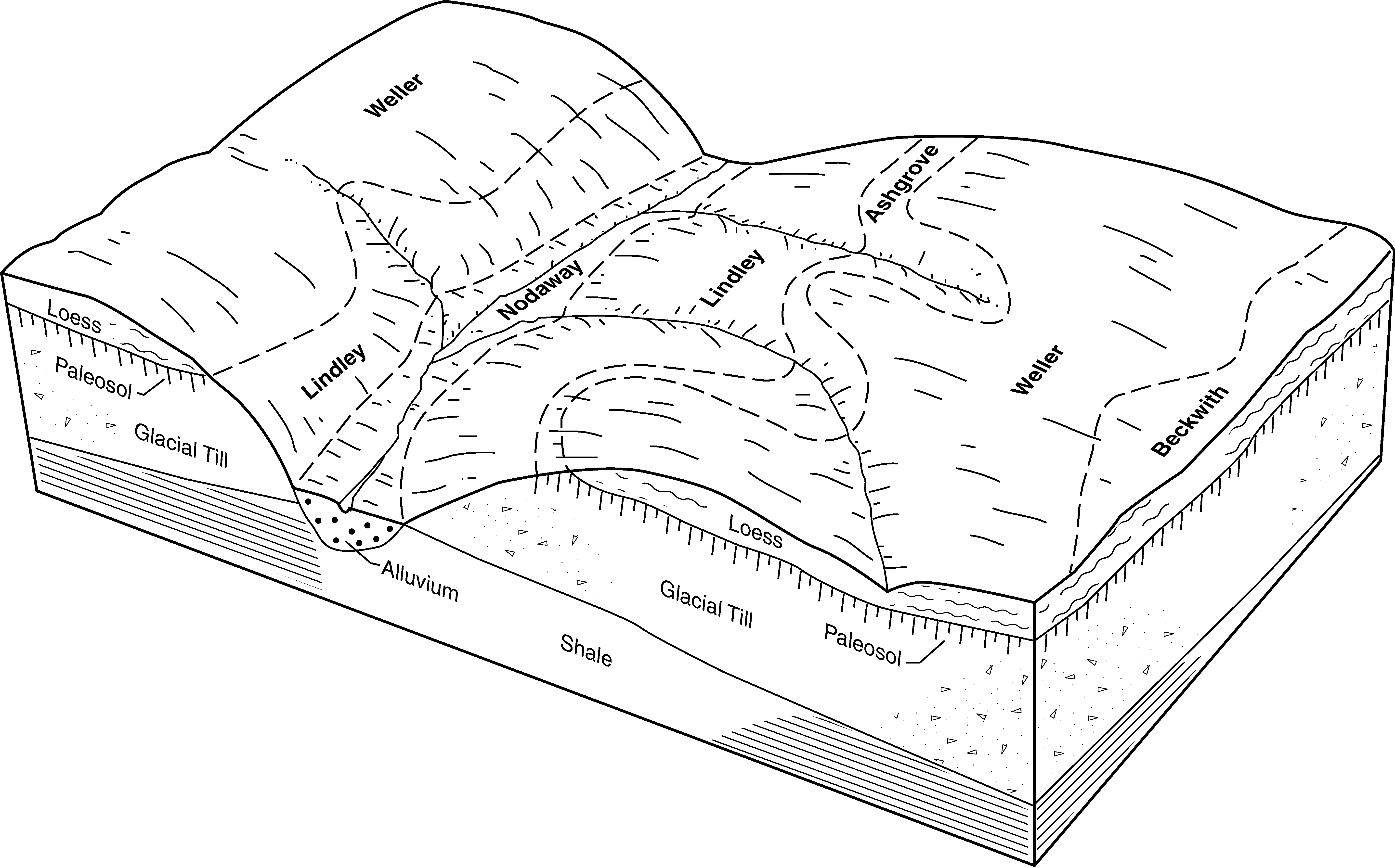
Nodaway-Lawson silt loams, heavy till, 0 to 2 percent slopes, occasionally flooded | 715 | 3606 | 3004691 | 2xjd7 | ia039 | 1987 | 1:15840 |
Nodaway-Lawson silt loams, 0 to 2 percent slopes, occasionally flooded | 737 | 1418 | 3046378 | 2xbm8 | ia039 | 1987 | 1:15840 |
Cantril-Nodaway complex, 0 to 9 percent slopes | 730C | 1370 | 404169 | fkkq | ia039 | 1987 | 1:15840 |
Nodaway silt loam, heavy till, 0 to 2 percent slopes, occasionally flooded | S220 | 950 | 3008713 | 2wjff | ia039 | 1987 | 1:15840 |
Nodaway-Lawson-Ackmore silt loams, 0 to 2 percent slopes | 1715 | 12590 | 404653 | fl2b | ia051 | 1988 | 1:15840 |
Nodaway-Amana silt loams, 0 to 2 percent slopes | 715 | 5723 | 404729 | fl4s | ia051 | 1988 | 1:15840 |
Nodaway-Cantril complex, 0 to 5 percent slopes | 730B | 3616 | 404730 | fl4t | ia051 | 1988 | 1:15840 |
Nodaway-Lawson-Klum complex, 0 to 3 percent slopes, occasionally flooded | 715 | 17605 | 3004689 | 2xjd6 | ia053 | 1986 | 1:15840 |
Cantril-Coppock-Nodaway complex, 2 to 9 percent slopes | 730C | 7902 | 404841 | fl8d | ia053 | 1986 | 1:15840 |
Nodaway silt loam, heavy till, 0 to 2 percent slopes, occasionally flooded | 220 | 2420 | 404775 | 2wjff | ia053 | 1986 | 1:15840 |
Nodaway-Cantril-Klum complex, 2 to 5 percent slopes | 730B | 4957 | 405274 | flqc | ia057 | 1980 | 1:15840 |
Nodaway silt loam, shallow loess, 0 to 2 percent slopes, occasionally flooded | 220 | 3315 | 405226 | 2wm7y | ia057 | 1980 | 1:15840 |
Napier-Nodaway-Colo complex, 2 to 5 percent slopes | 17B | 2702 | 406739 | 2y6b1 | ia085 | 1971 | 1:15840 |
Nodaway-Cantril complex, 2 to 5 percent slopes | 730B | 7484 | 406887 | 2wjg2 | ia087 | 1982 | 1:15840 |
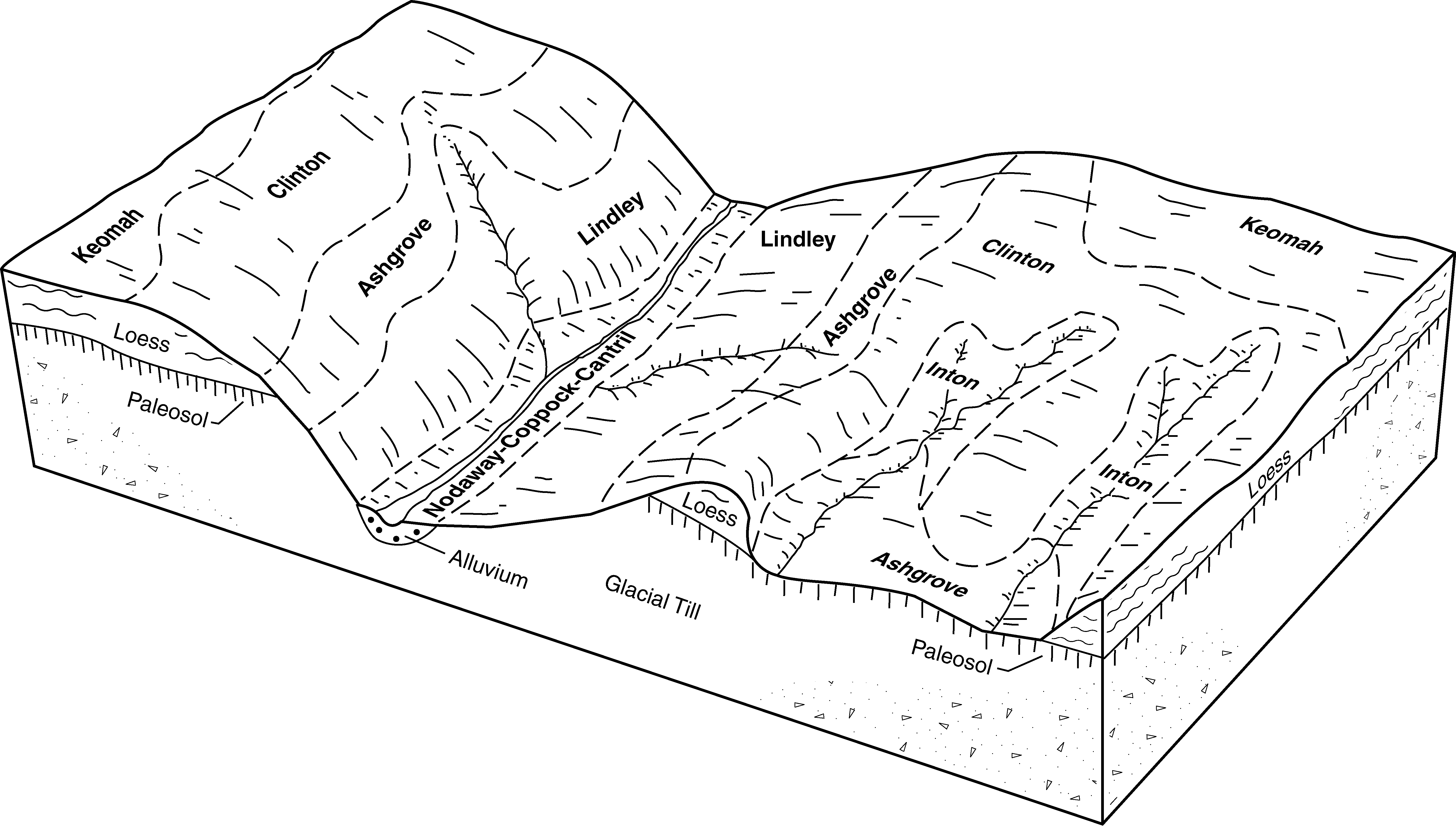
Klum-Perks-Nodaway complex, 1 to 3 percent slopes | 315 | 3540 | 406850 | fnc6 | ia087 | 1982 | 1:15840 |
Nodaway silt loam, shallow loess, 0 to 2 percent slopes, occasionally flooded | 220 | 2652 | 406828 | 2wm7y | ia087 | 1982 | 1:15840 |
Klum-Perks-Nodaway complex, channeled, 1 to 3 percent slopes | 1315 | 1015 | 406805 | fn9r | ia087 | 1982 | 1:15840 |
Nodaway silt loam, shallow loess, 0 to 2 percent slopes, occasionally flooded | 220 | 5174 | 452983 | 2wm7y | ia095 | 2005 | 1:12000 |
Amana-Nodaway-Lawson complex, 0 to 2 percent slopes, occasionally flooded | 2422 | 2819 | 1144373 | 17dt8 | ia095 | 2005 | 1:12000 |
Nodaway silt loam, shallow loess, 0 to 2 percent slopes, channeled, frequently flooded | 1220 | 900 | 452984 | 2wm7w | ia095 | 2005 | 1:12000 |
Nodaway silt loam, shallow loess, 0 to 2 percent slopes, frequently flooded | 6220 | 495 | 630209 | 2wm7x | ia095 | 2005 | 1:12000 |
Nodaway silt loam, shallow loess, 0 to 2 percent slopes, occasionally flooded | 220 | 8788 | 407634 | 2wm7y | ia099 | 1975 | 1:15840 |
Lawson-Nodaway-Colo Complex, 0 to 2 percent slopes, occasionally flooded | 314 | 3616 | 2506532 | 2q5sz | ia099 | 1975 | 1:15840 |
Nodaway silt loam, shallow loess, 0 to 2 percent slopes, occasionally flooded | 220 | 7116 | 407755 | 2wm7y | ia101 | 1992 | 1:15840 |
Nodaway-Vesser-Ackmore complex, 0 to 2 percent slopes | 1715 | 6993 | 407742 | fp8z | ia101 | 1992 | 1:15840 |
Nodaway-Coppock-Cantril complex, 2 to 5 percent slopes | 730B | 3558 | 407865 | 2wjfz | ia101 | 1992 | 1:15840 |
Nodaway-Coppock complex, 0 to 2 percent slopes, occasionally flooded | 729 | 1296 | 407863 | 30qw4 | ia101 | 1992 | 1:15840 |
Nodaway-Klum-Perks complex, 0 to 3 percent slopes | 315 | 462 | 407794 | fpbn | ia101 | 1992 | 1:15840 |
Nodaway-Arenzville silt loams, 1 to 4 percent slopes | 729B | 9747 | 408042 | fpln | ia103 | 1979 | 1:15840 |
Nodaway silt loam, shallow loess, 0 to 2 percent slopes, occasionally flooded | 220 | 3909 | 407981 | 2wm7y | ia103 | 1979 | 1:15840 |
Nodaway silt loam, shallow loess, 0 to 2 percent slopes, channeled, frequently flooded | 1220 | 1706 | 407936 | 2wm7w | ia103 | 1979 | 1:15840 |
Nodaway occasionally flooded-Coppock-Cantril rarely flooded complex, 2 to 5 percent slopes | 730B | 9873 | 447194 | 30qw5 | ia107 | 1998 | 1:12000 |
Nodaway-Ackmore-Vesser complex, 0 to 2 percent slopes, occasionally flooded | 722 | 7765 | 447192 | h0bk | ia107 | 1998 | 1:12000 |
Nodaway silt loam, shallow loess, 0 to 2 percent slopes, frequently flooded | 6220 | 6375 | 447170 | 2wm7x | ia107 | 1998 | 1:12000 |
Nodaway silt loam, shallow loess, 0 to 2 percent slopes, channeled, frequently flooded | 1220 | 6304 | 447022 | 2wm7w | ia107 | 1998 | 1:12000 |
Nodaway silt loam, shallow loess, 0 to 2 percent slopes, occasionally flooded | 220 | 2917 | 447053 | 2wm7y | ia107 | 1998 | 1:12000 |
Nodaway-Klum complex, channeled, 0 to 2 percent slopes, frequently flooded | 1315 | 1368 | 447026 | h056 | ia107 | 1998 | 1:12000 |
Nodaway-klum complex, 0 to 2 percent slopes, frequently flooded | 6315 | 631 | 447171 | h09w | ia107 | 1998 | 1:12000 |
Nodaway-Cantril complex, 2 to 5 percent slopes | 730B | 10599 | 408499 | 2wjg2 | ia111 | 1976 | 1:15840 |
Nodaway silt loam, heavy till, 0 to 2 percent slopes, occasionally flooded | S220 | 3601 | 3008714 | 2wjff | ia111 | 1976 | 1:15840 |
Nodaway silt loam, 0 to 2 percent slopes | 220 | 3413 | 408446 | fq0p | ia111 | 1976 | 1:15840 |
Ackmore-Nodaway complex, 2 to 5 percent slopes | 729B | 2921 | 2606442 | 21vfg | ia113 | 1970 | 1:15840 |
Nodaway silt loam, 0 to 2 percent slopes, occasionally flooded | 220 | 2037 | 2606433 | 1hwsn | ia113 | 1970 | 1:15840 |
Ackmore-Nodaway-Urban land complex, 2 to 5 percent slopes | 4729B | 656 | 2606468 | 2qcs8 | ia113 | 1970 | 1:15840 |
Nodaway silt loam, shallow loess, 0 to 2 percent slopes, occasionally flooded | 220 | 3342 | 408748 | 2wm7y | ia115 | 1984 | 1:15840 |
Nodaway-Klum complex, channeled, 0 to 5 percent slopes | 1730B | 1056 | 408740 | fqb5 | ia115 | 1984 | 1:15840 |
Nodaway silt loam, channeled, 0 to 2 percent slopes | 1220 | 513 | 408712 | fq98 | ia115 | 1984 | 1:15840 |
Lawson-Quiver-Nodaway complex, 0 to 2 percent slopes, occasionally flooded | 716 | 8296 | 2647640 | 2rlzm | ia117 | 1991 | 1:15840 |
Lawson-Nodaway-Colo complex, channeled, 0 to 2 percent slopes, frequently flooded | 1711 | 2804 | 408863 | 2m9vs | ia117 | 1991 | 1:15840 |
Lawson-Nodaway-Colo complex, 0 to 2 percent slopes, occasionally flooded | 711 | 2489 | 409023 | 2m9vr | ia117 | 1991 | 1:15840 |
Lawson-Quiver-Nodaway complex, 0 to 2 percent slopes, channeled, frequently flooded | 1716 | 197 | 2647641 | 2rlzl | ia117 | 1991 | 1:15840 |
Nodaway-Martinsburg silt loams, 2 to 5 percent slopes | 729B | 514 | 409235 | fqv4 | ia121 | 1968 | 1:15840 |
Nodaway silt loam, 0 to 2 percent slopes | 220 | 8119 | 409291 | fqwy | ia123 | 1971 | 1:15840 |
Nodaway-Vesser silt loams, 2 to 5 percent slopes | 13B | 5338 | 409280 | fqwl | ia123 | 1971 | 1:15840 |
Nodaway-Alluvial land complex, 0 to 2 percent slopes | 315 | 2656 | 409317 | fqxs | ia123 | 1971 | 1:15840 |
Lawson-Quiver-Nodaway complex, 0 to 2 percent slopes, occasionally flooded | 716 | 1354 | 2647651 | 2rlzm | ia123 | 1971 | 1:15840 |
Nodaway silt loam, shallow loess, 0 to 2 percent slopes, channeled, frequently flooded | C220 | 1101 | 409390 | 2wm7w | ia123 | 1971 | 1:15840 |
Lawson-Quiver-Nodaway complex, 0 to 2 percent slopes, occasionally flooded | 716 | 8758 | 2647645 | 2rlzm | ia125 | 1976 | 1:15840 |
Nodaway-Vesser silt loams, 2 to 5 percent slopes | 13B | 3960 | 412731 | fvgx | ia125 | 1976 | 1:15840 |
Nodaway silt loam, 0 to 2 percent slopes, channeled, frequently flooded | 1220 | 1150 | 412719 | 2wnyg | ia125 | 1976 | 1:15840 |
Lawson-Quiver-Nodaway complex, 0 to 2 percent slopes, channeled, frequently flooded | 1716 | 161 | 2647646 | 2rlzl | ia125 | 1976 | 1:15840 |
Nodaway silt loam, shallow loess, 0 to 2 percent slopes, occasionally flooded | 220 | 2972 | 409452 | 2wm7y | ia127 | 1978 | 1:15840 |
Nodaway silt loam, shallow loess, 0 to 2 percent slopes, channeled, frequently flooded | 1220 | 1865 | 409412 | 2wm7w | ia127 | 1978 | 1:15840 |
Lawson-Quiver-Nodaway complex, 0 to 2 percent slopes, occasionally flooded | 716 | 8612 | 2647644 | 2rlzm | ia135 | 1982 | 1:15840 |
Nodaway silt loam, 0 to 2 percent slopes, channeled, frequently flooded | 1220 | 257 | 409830 | 2wnyg | ia137 | 1987 | 1:15840 |
Nodaway, occasionally flooded-Urban land complex, 0 to 2 percent slopes | 4220 | 1357 | 412931 | fvpc | ia153 | 1993 | 1:12000 |
Nodaway silt loam, 0 to 2 percent slopes, channeled, frequently flooded | 1220 | 935 | 412826 | 2wnyg | ia153 | 1993 | 1:12000 |
Nodaway silt loam, shallow loess, 0 to 2 percent slopes, occasionally flooded | 220 | 6034 | 410562 | 2wm7y | ia157 | 1978 | 1:15840 |
Nodaway-Ackmore silt loams, channeled, 0 to 2 percent slopes | 1220 | 2271 | 410542 | fs69 | ia157 | 1978 | 1:15840 |
Nodaway silt loam, heavy till, 0 to 2 percent slopes, occasionally flooded | S220 | 13641 | 3008715 | 2wjff | ia159 | 1987 | 1:15840 |
Nodaway silt loam, shallow loess, 0 to 2 percent slopes, occasionally flooded | 220 | 1592 | 410939 | 2wm7y | ia163 | 1989 | 1:15840 |
Nodaway-Perks complex, channeled, 0 to 5 percent slopes | 1730B | 835 | 410914 | fsl9 | ia163 | 1989 | 1:15840 |
Nodaway-Urban land complex, 0 to 3 percent slopes | 4220 | 744 | 410989 | fsnq | ia163 | 1989 | 1:15840 |
Nodaway silt loam, shallow loess, 0 to 2 percent slopes, channeled, frequently flooded | 1220 | 2762 | 411372 | 2wm7w | ia171 | 1989 | 1:15840 |
Nodaway silt loam, shallow loess, 0 to 2 percent slopes, occasionally flooded | 220 | 869 | 411429 | 2wm7y | ia171 | 1989 | 1:15840 |
Colo-Judson-Nodaway complex, 0 to 5 percent slopes | 286B | 31511 | 411612 | 2wxsh | ia173 | 1989 | 1:15840 |
Nodaway-Vesser silt loams, 2 to 5 percent slopes | 13B | 5818 | 411676 | ftcw | ia175 | 1975 | 1:15840 |
Nodaway silt loam, heavy till, 0 to 2 percent slopes, occasionally flooded | S220 | 3656 | 3008716 | 2wjff | ia175 | 1975 | 1:15840 |
Nodaway-Coppock-Cantril complex, 2 to 5 percent slopes | 730B | 8293 | 413160 | 2wjfz | ia177 | 1994 | 1:12000 |
Nodaway silt loam, heavy till, 0 to 2 percent slopes, occasionally flooded | 220 | 6912 | 413033 | 2tfyr | ia177 | 1994 | 1:12000 |
Nodaway-Vesser-Mt. Sterling complex, 0 to 2 percent slopes, occasionally flooded | 1715 | 2637 | 413018 | fvs5 | ia177 | 1994 | 1:12000 |
Nodaway-Klum-Perks complex, 0 to 3 percent slopes, occasionally flooded | 315 | 1876 | 413063 | fvtm | ia177 | 1994 | 1:12000 |
Nodaway silt loam, 0 to 2 percent slopes, rarely flooded | 3220 | 1667 | 413066 | fvtq | ia177 | 1994 | 1:12000 |
Nodaway-Coppock complex, 0 to 2 percent slopes, occasionally flooded | 729 | 581 | 413158 | fvxp | ia177 | 1994 | 1:12000 |
Nodaway-Klum-Perks complex, 0 to 3 percent slopes, rarely flooded | 3315 | 380 | 413067 | fvtr | ia177 | 1994 | 1:12000 |
Nodaway-Cantril complex, 2 to 5 percent slopes | 730B | 12773 | 411841 | 2wjg2 | ia179 | 1978 | 1:15840 |
Lawson-Quiver-Nodaway complex, 0 to 2 percent slopes, occasionally flooded | 716 | 6033 | 2647648 | 2rlzm | ia179 | 1978 | 1:15840 |
Nodaway silt loam, heavy till, 0 to 2 percent slopes, occasionally flooded | S220 | 3111 | 3008717 | 2wjff | ia179 | 1978 | 1:15840 |
Landes-Perks-Nodaway complex, 1 to 3 percent slopes, frequently flooded | 315 | 2520 | 3004688 | 2xjd8 | ia179 | 1978 | 1:15840 |
Nodaway silt loam, 0 to 2 percent slopes | 220 | 1403 | 411779 | fth6 | ia179 | 1978 | 1:15840 |
Nodaway-Landes complex, 0 to 2 percent slopes | 715 | 755 | 411840 | ftk5 | ia179 | 1978 | 1:15840 |
Nodaway silt loam, channeled, 0 to 2 percent slopes | 1220 | 543 | 411756 | ftgg | ia179 | 1978 | 1:15840 |
Lawson-Quiver-Nodaway complex, 0 to 2 percent slopes, channeled, frequently flooded | 1716 | 198 | 2647649 | 2rlzl | ia179 | 1978 | 1:15840 |
Nodaway silt loam, heavy till, 0 to 2 percent slopes, occasionally flooded | S220 | 1073 | 3008718 | 2wjff | ia181 | 1975 | 1:15840 |
Nodaway silt loam, shallow loess, 0 to 2 percent slopes, occasionally flooded | 220 | 7619 | 412019 | 2wm7y | ia183 | 1983 | 1:15840 |
Ackmore-Nodaway silt loams, 2 to 5 percent slopes | 729B | 5180 | 412089 | ftt6 | ia183 | 1983 | 1:15840 |
Nodaway-Amana silt loams, 0 to 2 percent slopes | 2242 | 4027 | 412027 | ftr6 | ia183 | 1983 | 1:15840 |
Nodaway-Perks complex, 0 to 2 percent slopes, frequently flooded | 715 | 4001 | 412088 | 30qvw | ia183 | 1983 | 1:15840 |
Lawson-Nodaway-Colo complex, 0 to 2 percent slopes, occasionally flooded | 711 | 5093 | 2422549 | 2m9vr | ia185 | 1966 | 1:15840 |
Lawson-Nodaway-Colo complex, channeled, 0 to 2 percent slopes, frequently flooded | 1711 | 730 | 2422550 | 2m9vs | ia185 | 1966 | 1:15840 |
Nodaway silt loam, occasionally flooded | 7750 | 22 | 1475383 | 2x6bn | ks005 | 1998 | 1:24000 |
Nodaway silt loam, occasionally flooded | 7750 | 1478 | 1152190 | 2x6bn | ks013 | 1994 | 1:24000 |
Nodaway silt loam, channeled, frequently flooded | 7867 | 3 | 2505148 | 1trpp | ks013 | 1994 | 1:24000 |
Nodaway silt loam, occasionally flooded | 7750 | 412 | 747177 | 2x6bn | ks043 | 1977 | 1:24000 |
Nodaway silt loam, occasionally flooded | 7750 | 12765 | 1457094 | 2x6bn | ks117 | 1977 | 1:24000 |
Nodaway silt loam, channeled, occasionally flooded | 7868 | 184 | 2505149 | 1trr6 | ks117 | 1977 | 1:24000 |
Nodaway silt loam, occasionally flooded | 7750 | 93 | 2606036 | 2x6bn | ks131 | 1980 | 1:24000 |
Nodaway silt loam, channeled, occasionally flooded | 7868 | 73 | 2559431 | 1trr6 | ks201 | 1988 | 1:24000 |
Nodaway-Minneiska complex, 0 to 3 percent slopes, frequently flooded | N645A | 5244 | 1946889 | 23bww | mn157 | 2008 | 1:12000 |
Vigar-Zook-Nodaway complex, 1 to 5 percent slopes | 30217 | 152 | 2531950 | 2qnth | mo001 | 1992 | 1:24000 |
Nodaway silt loam, 0 to 2 percent slopes, frequently flooded | 36031 | 152 | 2532149 | 2qnvw | mo001 | 1992 | 1:24000 |
Nodaway silt loam, 1 to 3 percent slopes, occasionally flooded | 13626 | 973 | 2544508 | 2qs1d | mo003 | 1986 | 1:24000 |
Nodaway silt loam, 0 to 2 percent slopes, frequently flooded | 36031 | 2708 | 2532150 | 2qnvw | mo021 | 1984 | 1:24000 |
Nodaway silt loam, heavy till, 0 to 2 percent slopes, occasionally flooded | 36117 | 930 | 2528441 | 2tfyr | mo025 | 1967 | 1:24000 |
Nodaway silt loam, 1 to 3 percent slopes, occasionally flooded | 13626 | 732 | 2544500 | 2qs1d | mo025 | 1967 | 1:24000 |
Nodaway silt loam, 0 to 2 percent slopes, frequently flooded | 36031 | 23896 | 2532151 | 2qnvw | mo033 | 1988 | 1:24000 |
Nodaway silt loam, 1 to 3 percent slopes, frequently flooded | 36087 | 4424 | 2544576 | 2qs2d | mo033 | 1988 | 1:24000 |
Nodaway silt loam, heavy till, 0 to 2 percent slopes, occasionally flooded | 36117 | 362 | 2528446 | 2tfyr | mo033 | 1988 | 1:24000 |
Nodaway silt loam, heavy till, 0 to 2 percent slopes, occasionally flooded | 36117 | 425 | 2528449 | 2tfyr | mo041 | 1992 | 1:24000 |
Nodaway silt loam, heavy till, 0 to 2 percent slopes, occasionally flooded | 36117 | 109 | 2528451 | 2tfyr | mo045 | 1992 | 1:24000 |
Nodaway silt loam, heavy till, 0 to 2 percent slopes, occasionally flooded | 36117 | 10032 | 2528452 | 2tfyr | mo047 | 1982 | 1:24000 |
Nodaway silt loam, 1 to 3 percent slopes, occasionally flooded | 13626 | 7004 | 2544506 | 2qs1d | mo047 | 1982 | 1:24000 |
Nodaway silt loam, 0 to 2 percent slopes, frequently flooded | 36031 | 219 | 2532156 | 2qnvw | mo047 | 1982 | 1:24000 |
Nodaway silt loam, 1 to 3 percent slopes, frequently flooded | 36087 | 203 | 2544575 | 2qs2d | mo047 | 1982 | 1:24000 |
Nodaway silt loam, heavy till, 0 to 2 percent slopes, occasionally flooded | 36117 | 5257 | 2528438 | 2tfyr | mo049 | 1981 | 1:24000 |
Nodaway silt loam, 1 to 3 percent slopes, frequently flooded | 36087 | 62 | 2544573 | 2qs2d | mo049 | 1981 | 1:24000 |
Nodaway silt loam, 0 to 2 percent slopes, frequently flooded | 36031 | 23 | 2532152 | 2qnvw | mo049 | 1981 | 1:24000 |
Nodaway silt loam, heavy till, 0 to 2 percent slopes, occasionally flooded | 36117 | 27818 | 2528440 | 2tfyr | mo061 | 1952 | 1:24000 |
Nodaway silt loam, 1 to 3 percent slopes, occasionally flooded | 13626 | 4742 | 2544498 | 2qs1d | mo061 | 1952 | 1:24000 |
Nodaway silt loam, heavy till, 0 to 2 percent slopes, occasionally flooded | 36117 | 21097 | 2528437 | 2tfyr | mo075 | 1982 | 1:24000 |
Nodaway silt loam, 1 to 3 percent slopes, occasionally flooded | 13626 | 2728 | 2544505 | 2qs1d | mo075 | 1982 | 1:24000 |
Nodaway silt loam, heavy till, 0 to 2 percent slopes, occasionally flooded | 36117 | 11788 | 2528444 | 2tfyr | mo079 | 1988 | 1:24000 |
Nodaway silt loam, heavy till, 0 to 2 percent slopes, occasionally flooded | 36117 | 30005 | 2528439 | 2tfyr | mo081 | 1975 | 1:24000 |
Nodaway silt loam, 1 to 3 percent slopes, occasionally flooded | 13626 | 877 | 2544502 | 2qs1d | mo081 | 1975 | 1:24000 |
Nodaway-Judson silt loams, 1 to 7 percent slopes | 13564 | 2958 | 887524 | ysjt | mo087 | 1992 | 1:24000 |
Nodaway silt loam, 1 to 3 percent slopes, frequently flooded | 36087 | 13182 | 2575548 | 2qs2d | mo089 | 1975 | 1:24000 |
Nodaway silt loam, heavy till, 0 to 2 percent slopes, occasionally flooded | 36117 | 3585 | 2528431 | 2tfyr | mo089 | 1975 | 1:24000 |
Nodaway silt loam, 1 to 3 percent slopes, occasionally flooded | 13626 | 3482 | 2575550 | 2qs1d | mo089 | 1975 | 1:24000 |
Nodaway silt loam, 0 to 2 percent slopes, frequently flooded | 36031 | 328 | 2532153 | 2qnvw | mo089 | 1975 | 1:24000 |
Nodaway silt loam, heavy till, 0 to 2 percent slopes, occasionally flooded | 36117 | 16102 | 2528429 | 2tfyr | mo101 | 1977 | 1:24000 |
Nodaway silt loam, 1 to 3 percent slopes, occasionally flooded | 13626 | 11151 | 2579902 | 2qs1d | mo101 | 1977 | 1:24000 |
Nodaway silt loam, heavy till, 0 to 2 percent slopes, occasionally flooded | 36117 | 1635 | 2528442 | 2tfyr | mo107 | 1970 | 1:24000 |
Nodaway silt loam, 1 to 3 percent slopes, occasionally flooded | 13626 | 1303 | 2544501 | 2qs1d | mo107 | 1970 | 1:24000 |
Nodaway silt loam, heavy till, 0 to 2 percent slopes, occasionally flooded | 36117 | 375 | 2528445 | 2tfyr | mo117 | 1996 | 1:24000 |
Nodaway silt loam, heavy till, 0 to 2 percent slopes, occasionally flooded | 36117 | 20505 | 2528443 | 2tfyr | mo129 | 1993 | 1:24000 |
Nodaway-Humeston-Vigar complex, 1 to 6 percent slopes | 36089 | 12418 | 2544579 | 2qs2g | mo129 | 1993 | 1:24000 |
Nodaway silt loam, 1 to 3 percent slopes, occasionally flooded | 13626 | 105 | 2544510 | 2qs1d | mo129 | 1993 | 1:24000 |
Nodaway silt loam, 0 to 2 percent slopes, frequently flooded | 36031 | 6722 | 2532157 | 2qnvw | mo139 | 1975 | 1:24000 |
Nodaway silt loam, 1 to 3 percent slopes, frequently flooded | 36087 | 93 | 2575545 | 2qs2d | mo139 | 1975 | 1:24000 |
Nodaway silt loam, 1 to 3 percent slopes, occasionally flooded | 13626 | 754 | 2671840 | 2qs1d | mo147 | 1983 | 1:24000 |
Nodaway silt loam, heavy till, 0 to 2 percent slopes, occasionally flooded | 36117 | 668 | 2528435 | 2tfyr | mo147 | 1983 | 1:24000 |
Nodaway silt loam, 0 to 2 percent slopes, frequently flooded | 36031 | 11386 | 2532154 | 2qnvw | mo165 | 1982 | 1:24000 |
Nodaway silt loam, 1 to 3 percent slopes, frequently flooded | 36087 | 1455 | 2544574 | 2qs2d | mo165 | 1982 | 1:24000 |
Nodaway silt loam, 0 to 2 percent slopes, frequently flooded | 36031 | 16912 | 2532155 | 2qnvw | mo171 | 1989 | 1:24000 |
Vigar-Zook-Nodaway complex, 2 to 5 percent slopes | 30245 | 16263 | 2544515 | 2qs1m | mo171 | 1989 | 1:24000 |
Vigar-Zook-Nodaway complex, 1 to 5 percent slopes | 30217 | 490 | 2531951 | 2qnth | mo171 | 1989 | 1:24000 |
Nodaway silt loam, 1 to 3 percent slopes, frequently flooded | 36087 | 220 | 2544577 | 2qs2d | mo171 | 1989 | 1:24000 |
Nodaway silt loam, 1 to 3 percent slopes, occasionally flooded | 13626 | 166 | 2544509 | 2qs1d | mo171 | 1989 | 1:24000 |
Nodaway silt loam, heavy till, 0 to 2 percent slopes, occasionally flooded | 36117 | 85 | 2528448 | 2tfyr | mo171 | 1989 | 1:24000 |
Nodaway silt loam, 1 to 3 percent slopes, occasionally flooded | 13626 | 33 | 2544507 | 2qs1d | mo175 | 1986 | 1:24000 |
Nodaway silt loam, heavy till, 0 to 2 percent slopes, occasionally flooded | 36117 | 11 | 2528450 | 2tfyr | mo175 | 1986 | 1:24000 |
Nodaway silt loam, heavy till, 0 to 2 percent slopes, occasionally flooded | 36117 | 15547 | 2528428 | 2tfyr | mo177 | 1979 | 1:24000 |
Nodaway silt loam, 1 to 3 percent slopes, occasionally flooded | 13626 | 5879 | 2544503 | 2qs1d | mo177 | 1979 | 1:24000 |
Nodaway silt loam, heavy till, 0 to 2 percent slopes, occasionally flooded | 36117 | 1294 | 2528447 | 2tfyr | mo195 | 1989 | 1:24000 |
Vigar-Zook-Nodaway complex, 2 to 5 percent slopes | 30245 | 377 | 2544516 | 2qs1m | mo211 | 1990 | 1:24000 |
Vigar-Zook-Nodaway complex, 1 to 5 percent slopes | 30217 | 316 | 2531949 | 2qnth | mo211 | 1990 | 1:24000 |
Nodaway silt loam, 0 to 2 percent slopes, frequently flooded | 36031 | 1703 | 2532148 | 2qnvw | mo219 | 1975 | 1:24000 |
Nodaway silt loam, 1 to 3 percent slopes, frequently flooded | 36087 | 73 | 2575519 | 2qs2d | mo219 | 1975 | 1:24000 |
Nodaway silt loam, 0 to 2 percent slopes, overflow, frequently flooded | 36032 | 3799 | 887702 | ysqk | mo227 | 1965 | 1:24000 |
Nodaway silt loam, 0 to 2 percent slopes, overflow, occasionally flooded | 36030 | 2989 | 984570 | 121jb | mo227 | 1965 | 1:24000 |
Nodaway silt loam, heavy till, 0 to 2 percent slopes, occasionally flooded | 36117 | 1083 | 2528436 | 2tfyr | mo227 | 1965 | 1:24000 |
Nodaway silt loam, 1 to 3 percent slopes, occasionally flooded | 13626 | 294 | 2544499 | 2qs1d | mo227 | 1965 | 1:24000 |
Nodaway silt loam, 1 to 3 percent slopes, frequently flooded | 36087 | 208 | 2607692 | 2qs2d | mo227 | 1965 | 1:24000 |
Nodaway silt loam, 0 to 2 percent slopes, channeled, frequently flooded | 7867 | 595 | 427832 | 2wnyg | ne021 | 1978 | 1:20000 |
Napier-Nodaway-Gullied land complex, 0 to 60 percent slopes | 8108 | 12 | 2216688 | 2wnyh | ne021 | 1978 | 1:20000 |
Nodaway silt loam, occasionally flooded | 7750 | 884 | 2219047 | 2x6bn | ne023 | 1979 | 1:20000 |
Nodaway silt loam, channeled, frequently flooded | 7867 | 753 | 2219058 | 2dh3j | ne023 | 1979 | 1:20000 |
Nodaway silt loam, channeled, occasionally flooded | 7868 | 686 | 2219048 | 2dh36 | ne023 | 1979 | 1:20000 |
Nodaway silt loam, channeled, frequently flooded | 7867 | 14660 | 1691489 | 1ts45 | ne025 | 1981 | 1:20000 |
Colo-Nodaway complex, frequently flooded | 7773 | 13844 | 1691462 | 1ts39 | ne025 | 1981 | 1:20000 |
Nodaway silt loam, occasionally flooded | 7750 | 8719 | 1691488 | 2x6bn | ne025 | 1981 | 1:20000 |
Nodaway silt loam, channeled, occasionally flooded | 7868 | 45 | 2216031 | 2dcyw | ne025 | 1981 | 1:20000 |
Judson-Nodaway channeled-Contrary complex, 0 to 12 percent slopes | 7235 | 492 | 1710951 | 2zv9f | ne055 | 2007 | 1:12000 |
Nodaway silt loam, channeled, occasionally flooded | 7868 | 25936 | 1691118 | 1trr6 | ne067 | 2000 | 1:12000 |
Nodaway silt loam, occasionally flooded | 7750 | 25605 | 1691117 | 2x6bn | ne067 | 2000 | 1:12000 |
Nodaway silt loam, channeled, frequently flooded | 7867 | 172 | 2219227 | 2dh8z | ne067 | 2000 | 1:12000 |
Nodaway silt loam, occasionally flooded | 7750 | 7858 | 1691771 | 2x6bn | ne095 | 1970 | 1:20000 |
Nodaway silt loam, channeled, occasionally flooded | 7868 | 5696 | 1691772 | 1tsf9 | ne095 | 1970 | 1:20000 |
Nodaway silt loam, occasionally flooded | 7750 | 15379 | 1691588 | 2x6bn | ne097 | 1984 | 1:20000 |
Nodaway silt loam, channeled, frequently flooded | 7867 | 6591 | 1691589 | 1ts7d | ne097 | 1984 | 1:20000 |
Kennebec-Nodaway silt loams, rarely flooded | 7154 | 3390 | 1691576 | 1ts6z | ne097 | 1984 | 1:20000 |
Nodaway silt loam, channeled, occasionally flooded | 7868 | 514 | 2219368 | 2dhfj | ne097 | 1984 | 1:20000 |
Nodaway silt loam, channeled, frequently flooded | 7867 | 15029 | 1691375 | 1ts0h | ne109 | 1977 | 1:20000 |
Nodaway silt loam, occasionally flooded | 7750 | 10790 | 1691374 | 2x6bn | ne109 | 1977 | 1:20000 |
Burchard-Nodaway complex, 2 to 30 percent slopes | 7211 | 6804 | 1691341 | 2v8xq | ne109 | 1977 | 1:20000 |
Colo-Nodaway silty clay loams, frequently flooded | 7774 | 6585 | 1691347 | 1trzl | ne109 | 1977 | 1:20000 |
Nodaway silt loam, channeled, occasionally flooded | 7868 | 1015 | 2219245 | 2dh9k | ne109 | 1977 | 1:20000 |
Colo-Nodaway complex, frequently flooded | 7773 | 233 | 2219259 | 2dhb0 | ne109 | 1977 | 1:20000 |
Nodaway silt loam, channeled, frequently flooded | 7867 | 8396 | 1691684 | 1tsbg | ne127 | 1983 | 1:20000 |
Nodaway silt loam, occasionally flooded | 7750 | 7249 | 1691683 | 2x6bn | ne127 | 1983 | 1:20000 |
Nodaway-Colo silt loams, occasionally flooded | 7871 | 7055 | 1691685 | 1tsbh | ne127 | 1983 | 1:20000 |
Kennebec-Nodaway silt loams, occasionally flooded | 7057 | 1785 | 1691666 | 1ts9w | ne127 | 1983 | 1:20000 |
Nodaway-Colo complex, occasionally flooded | 7870 | 32 | 2219385 | 2dhg2 | ne127 | 1983 | 1:20000 |
Nodaway-Colo complex, occasionally flooded | 7870 | 32272 | 1691546 | 1ts60 | ne131 | 1979 | 1:20000 |
Nodaway silt loam, occasionally flooded | 7750 | 8956 | 1691545 | 2x6bn | ne131 | 1979 | 1:20000 |
Kennebec-Nodaway silt loams, occasionally flooded | 7057 | 2314 | 1691529 | 1ts5g | ne131 | 1979 | 1:20000 |
Nodaway silt loam, channeled, frequently flooded | 7867 | 1016 | 2219322 | 2dhd1 | ne131 | 1979 | 1:20000 |
Colo-Nodaway complex, frequently flooded | 7773 | 644 | 2219334 | 2dhdf | ne131 | 1979 | 1:20000 |
Nodaway-Colo silt loams, occasionally flooded | 7871 | 331 | 2219324 | 2dhd3 | ne131 | 1979 | 1:20000 |
Kennebec-Nodaway silt loams, rarely flooded | 7154 | 38 | 2219317 | 2dhcw | ne131 | 1979 | 1:20000 |
Nodaway silt loam, occasionally flooded | 7750 | 9433 | 1691641 | 2x6bn | ne133 | 1969 | 1:15840 |
Nodaway silt loam, channeled, occasionally flooded | 7868 | 427 | 2219398 | 2dhgh | ne133 | 1969 | 1:15840 |
Kennebec-Nodaway silt loams, rarely flooded | 7154 | 296 | 2219400 | 2dhgk | ne133 | 1969 | 1:15840 |
Nodaway silt loam, channeled, frequently flooded | 7867 | 47 | 2219397 | 2dhgg | ne133 | 1969 | 1:15840 |
Nodaway silt loam, occasionally flooded | 7750 | 8369 | 1691037 | 2x6bn | ne147 | 1967 | 1:20000 |
Nodaway silt loam, channeled, frequently flooded | 7867 | 899 | 1691071 | 1trpp | ne147 | 1967 | 1:20000 |
Nodaway-Colo silt loams, occasionally flooded | 7871 | 330 | 2229045 | 2dthp | ne147 | 1967 | 1:20000 |
Nodaway silt loam, channeled, occasionally flooded | 7868 | 1256 | 2219187 | 2dh7p | ne151 | 1985 | 1:20000 |
Nodaway silt loam, occasionally flooded | 7750 | 307 | 2219186 | 2x6bn | ne151 | 1985 | 1:20000 |
Judson-Nodaway channeled-Contrary complex, 0 to 12 percent slopes | 7235 | 2782 | 1711015 | 2zv9f | ne153 | 2007 | 1:12000 |
Nodaway silt loam, occasionally flooded | 7750 | 31932 | 1691434 | 2x6bn | ne155 | 1995 | 1:12000 |
Nodaway silt loam, channeled, occasionally flooded | 7868 | 7803 | 1691435 | 1ts2f | ne155 | 1995 | 1:12000 |
Nodaway silt loam, channeled, frequently flooded | 7867 | 1363 | 2219132 | 2dh5x | ne159 | 1967 | 1:20000 |
Nodaway silt loam, occasionally flooded | 7750 | 182 | 2219131 | 2x6bn | ne159 | 1967 | 1:20000 |
Napier-Nodaway-Gullied land complex, 0 to 60 percent slopes | 8108 | 1918 | 395534 | 2wnyh | ne177 | 2000 | 1:12000 |
Judson-Nodaway channeled-Contrary complex, 0 to 12 percent slopes | 7235 | 192 | 2217303 | 2zv9f | ne177 | 2000 | 1:12000 |