Official Series Description


Lab Data Summary

Aggregate lab data for the MILOK soil series. This aggregation is based on all pedons with a current taxon name of MILOK, and applied along 1-cm thick depth slices. Solid lines are the slice-wise median, bounded on either side by the interval defined by the slice-wise 5th and 95th percentiles. The median is the value that splits the data in half. Five percent of the data are less than the 5th percentile, and five percent of the data are greater than the 95th percentile. Values along the right hand side y-axis describe the proportion of pedon data that contribute to aggregate values at this depth. For example, a value of "90%" at 25cm means that 90% of the pedons correlated to MILOK were used in the calculation. Source: KSSL snapshot . Methods used to assemble the KSSL snapshot used by SoilWeb / SDE

Click the image to view it full size.

Pedons used in the lab summary:

MLRALab IDPedon IDTaxonnameCINSSL / NASIS ReportsLink To SoilWeb GMap
3506N0155S2005UT019025Milok6Primary | Supplementary | Taxonomy | Pedon | Water Retention | Correlation | Andic Soil Properties38.7730331,-109.6456833
3509N1050S2009UT025001Milok7Primary | Supplementary | Taxonomy | Pedon | Water Retention | Correlation | Andic Soil Properties37.195446,-112.1986389

Water Balance

Monthly water balance estimated using a leaky-bucket style model for the MILOK soil series. Monthly precipitation (PPT) and potential evapotranspiration (PET) have been estimated from the 50th percentile of gridded values (PRISM 1981-2010) overlapping with the extent of SSURGO map units containing each series as a major component. Monthly PET values were estimated using the method of Thornthwaite (1948). These (and other) climatic parameters are calculated with each SSURGO refresh and provided by the fetchOSD function of the soilDB package. Representative water storage values (“AWC” in the figures) were derived from SSURGO by taking the 50th percentile of profile-total water storage (sum[awc_r * horizon thickness]) for each soil series. Note that this representation of “water storage” is based on the average ability of most plants to extract soil water between 15 bar (“permanent wilting point”) and 1/3 bar (“field capacity”) matric potential. Soil moisture state can be roughly interpreted as “dry” when storage is depleted, “moist” when storage is between 0mm and AWC, and “wet” when there is a surplus. Clearly there are a lot of assumptions baked into this kind of monthly water balance. This is still a work in progress.

Click the image to view it full size.


Click the image to view it full size.

Sibling Summary

Siblings are those soil series that occur together in map units, in this case with the MILOK series. Sketches are arranged according to their subgroup-level taxonomic structure. Source: SSURGO snapshot , parsed OSD records and snapshot of SC database .

Click the image to view it full size.

Select annual climate data summaries for the MILOK series and siblings. Series are sorted according to hierarchical clustering of median values. Source: SSURGO map unit geometry and 1981-2010, 800m PRISM data .

Click the image to view it full size.

Geomorphic description summaries for the MILOK series and siblings. Series are sorted according to hierarchical clustering of proportions and relative hydrologic position within an idealized landform (e.g. top to bottom). Most soil series (SSURGO components) are associated with a hillslope position and one or more landform-specific positions: hills, mountain slopes, terraces, and/or flats. Proportions can be interpreted as an aggregate representation of geomorphic membership. The values printed to the left (number of component records) and right (Shannon entropy) of stacked bars can be used to judge the reliability of trends. Small Shannon entropy values suggest relatively consistent geomorphic association, while larger values suggest lack thereof. Source: SSURGO component records .

Click the image to view it full size.

Click the image to view it full size.

Click the image to view it full size.

Click the image to view it full size.

Click the image to view it full size.

Competing Series

Soil series competing with MILOK share the same family level classification in Soil Taxonomy. Source: parsed OSD records and snapshot of the SC database .

Click the image to view it full size.

Select annual climate data summaries for the MILOK series and competing. Series are sorted according to hierarchical clustering of median values. Source: SSURGO map unit geometry and 1981-2010, 800m PRISM data .

Click the image to view it full size.

Geomorphic description summaries for the MILOK series and competing. Series are sorted according to hierarchical clustering of proportions and relative hydrologic position within an idealized landform (e.g. top to bottom). Proportions can be interpreted as an aggregate representation of geomorphic membership. Most soil series (SSURGO components) are associated with a hillslope position and one or more landform-specific positions: hills, mountain slopes, terraces, and/or flats. The values printed to the left (number of component records) and right (Shannon entropy) of stacked bars can be used to judge the reliability of trends. Shannon entropy values close to 0 represent soil series with relatively consistent geomorphic association, while values close to 1 suggest lack thereof. Source: SSURGO component records .

Click the image to view it full size.

Click the image to view it full size.

There are insufficient data to create the 3D mountains figure.

Click the image to view it full size.

Click the image to view it full size.

Soil series sharing subgroup-level classification with MILOK, arranged according to family differentiae. Hovering over a series name will print full classification and a small sketch from the OSD. Source: snapshot of SC database .

Block Diagrams

No block diagrams are available.

Map Units

Map units containing MILOK as a major component. Limited to 250 records.

Map Unit Name Symbol Map Unit Area (ac) Map Unit Key National Map Unit Symbol Soil Survey Area Publication Date Map Scale
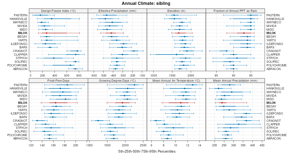
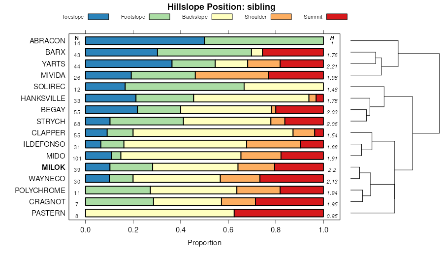
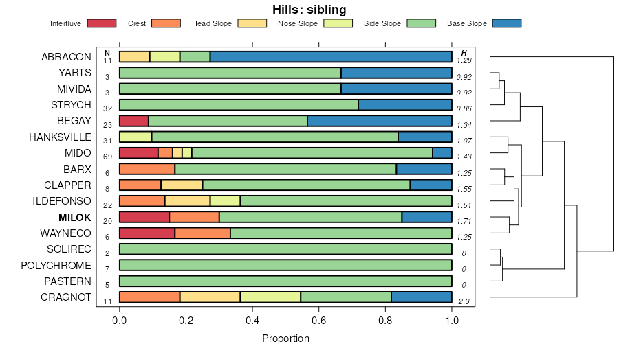
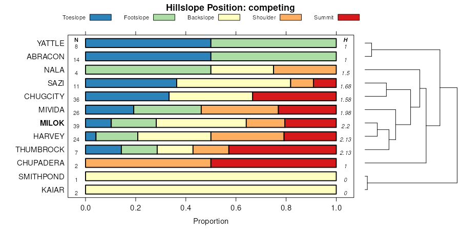
Milok gravelly loam, 1 to 15 percent slopes392644525241rnbaz62519921:24000
Milok-Pastern complex, 4 to 12 percent slopes8910298798447vsvcaz69720051:24000
Milok-Pastern complex, 4 to 12 percent slopes26730545311tr2az69919931:24000
Begay-Mido-Milok complex, 1 to 5 percent slopes319258141142rqqmaz70720111:24000
Milok-Mido complex, 1 to 12 percent slopes1911440547031txmaz71419851:24000
Begay-Milok family-Mathis family complex, 1 to 60 percent slopes1138981580552qszfaz71520071:24000
Milok-Pinavetes families complex, 1 to 12 percent slopes613708580692qszsaz71520071:24000
Milok-Solirec-Strych complex, 10 to 65 percent slopes, very stony239168629843p4djco68619921:31680
Milok-Strych complex, 3 to 25 percent slopes, very stony240137629844p4dkco68619921:31680
Milok fine sandy loam, 3 to 8 percent slopes2381306298422wrfvco68619921:31680
Milok-Solirec-Strych complex, 10 to 65 percent slopes, very stony382766506258jzsxco69219981:24000
Milok-Strych complex, 3 to 25 percent slopes, very stony392133506260jzszco69219981:24000
Milok fine sandy loam, 3 to 8 percent slopes3720325062572wrfvco69219981:24000
Polychrome-Milok complex, 8 to 50 percent slopes441632506265jzt4co69219981:24000
Milok-Solirec-Mespun complex, 1 to 8 percent slopesMmB446124084002lv4but0131:24000
Milok fine sandy loam, 3 to 8 percent slopes141363322483632wrfvut0131:24000
Milok-Montwel-Badland association, 3 to 25 percent slopes14226233505409jyxjut04719991:24000
Milok fine sandy loam, 3 to 8 percent slopes141173315054082wrfvut04719991:24000
Polychrome-Milok complex, 8 to 50 percent slopes1831029505454jyyzut04719991:24000
Milok-Strych complex, 3 to 25 percent slopes, very stony14384505410jyxkut04719991:24000
Mido-Wayneco-Milok families complex, 2 to 30 percent slopes4127154731938772z93gut6251:24000
Milok, very stony-Strych, extremely stony complex, 2 to 15 percent slopesCLB4719504623jy35ut6291:24000
Paradox-Milok complex, 0 to 8 percent slopesELB1492504642jy3sut6291:24000
Milok-Begay complex5012796551791vdzut63119821:24000
Mido-Wayneco-Milok complex4711096551751vdvut63119821:24000
Milok-Mido complex526161551811vf1ut63119821:24000
Milok-Pastern complex533045551821vf2ut63119821:24000
Wayneco-Milok-Rock outcrop complex1182732551301vcdut63119821:24000
Milok-Chipeta complex511551551801vf0ut63119821:24000
Milok loamy fine sand, 4 to 8 percent slopes481195551761vdwut63119821:24000
Milok sandy loam49460551771vdxut63119821:24000
Milok-Mivida complex2424589554471vpmut63819851:24000
Milok fine sandy loam, 1 to 6 percent slopes2310154554461vplut63819851:24000
Milok-Skos-Strych complex252896554481vpnut63819851:24000
Milok-Ildefonso-Millett complex, 8 to 35 percent slopes53425424855532pff4ut6421:63360
Begay-Milok-Ildefonso complex, 2 to 8 percent slopes8351724854982pfccut6421:63360
Milok-Barx-Rizno complex, 0 to 8 percent slopes201942228839132sp8hut64319761:63000
Remorris-Milok-Rock outcrop complex, 10 to 60 percent slopes78849325074572q70tut68519901:24000
Milok-Clapper complex, 2 to 20 percent slopes4230525149992qdqqut68519901:24000
Milok, steep-Strych complex, 15 to 60 percent slopes4322225149982qdqput68519901:24000
Sanostee, warm-Milok-Lazear, warm complex, 2 to 15 percent slopes51559938598702099ut68620041:24000
Milok, cool-Barx, dry complex, 1 to 5 percent slopes5003371859748205cut68620041:24000
Sazi-Milok, cool complex, 2 to 30 percent slopes5040318059785206kut68620041:24000
Milok fine sandy loam, cool, 2 to 8 percent slopes5006227959751205gut68620041:24000
Milok-ThumbRock complex, cool 2 to 8 percent slopes5021210559766205yut68620041:24000
Milok fine sand, 2 to 8 percent slopes5053195059815207jut68620041:24000
Milok-Mido, strongly calcareous complex, 2 to 15 percent slopes1085027186879520qmqut68720091:24000
Milok very gravelly sandy loam, 2 to 15 percent slopes, eroded1293501884181217n1ut68720091:24000
Strych-Milok complex, 0 to 15 percent slopes1853850504050jxhpwy63819901:24000
Milok sandy loam, 2 to 6 percent slopes1571955504014jxgjwy63819901:24000

Map of Series Extent

Approximate geographic distribution of the MILOK soil series. To learn more about how this distribution was mapped, or to compare this soil series extent to others, use the Series Extent Explorer (SEE) application. Source: generalization of SSURGO geometry .