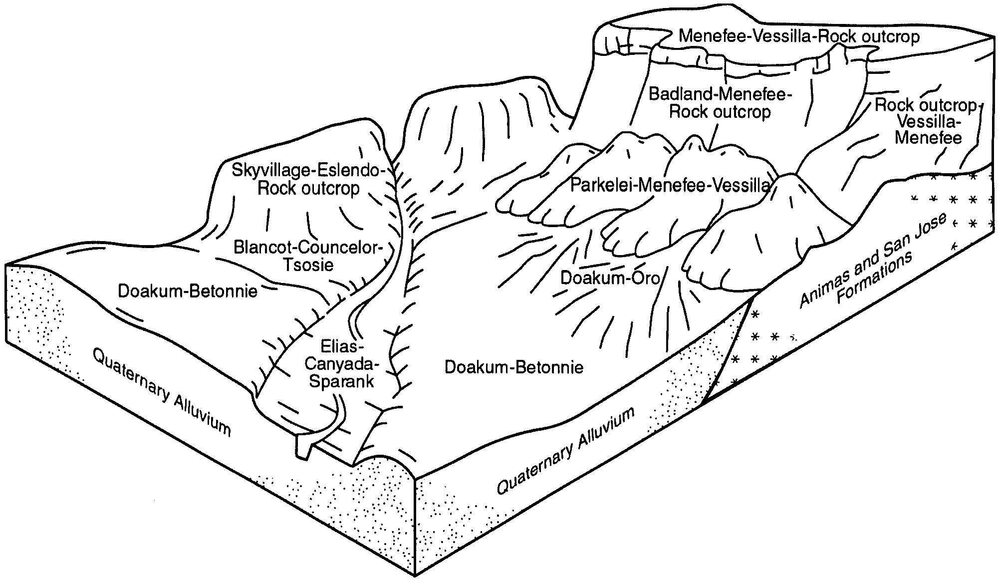
| Rock outcrop-Vessilla-Menefee complex, 15 to 45 percent slopes | 220A | 571 | 1670769 | 1t2ks | co668 | 2018 | 1:24000 |
Atarque-Menefee-Rock outcrop complex, 25 to 45 percent slopes | 396 | 90 | 3043851 | 1wpq | nm606 | 1965 | 1:24000 |
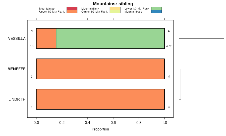
Vessilla-Menefee-Orlie complex, 1 to 30 percent slopes | 110 | 168998 | 56163 | 2vd1r | nm650 | 1989 | 1:24000 |
Rock outcrop-Vessilla-Menefee complex, 15 to 45 percent slopes | 220 | 104029 | 56229 | 1whv | nm650 | 1989 | 1:24000 |
Pinitos-Menefee-Vessilla complex, 2 to 20 percent slopes | 40 | 48287 | 56255 | 1wjp | nm650 | 1989 | 1:24000 |
Menefee-Vessilla-Rock outcrop complex, 5 to 35 percent slopes | 20 | 24568 | 56223 | 2wljg | nm650 | 1989 | 1:24000 |
Menefee channery loam, 2 to 35 percent slopes | 115 | 15116 | 56168 | 1wfw | nm650 | 1989 | 1:24000 |
Menefee-Nalivag complex, 8 to 25 percent slopes | 102 | 5010 | 56156 | 1wfh | nm650 | 1989 | 1:24000 |
Vessilla-Menefee-Rock outcrop complex, 3 to 15 percent slopes | 17 | 30571 | 56337 | 1wmb | nm656 | 1987 | 1:24000 |
Vessilla-Menefee-Orlie association, 0 to 30 percent slopes | 422 | 26540 | 56426 | 1wq6 | nm656 | 1987 | 1:24000 |
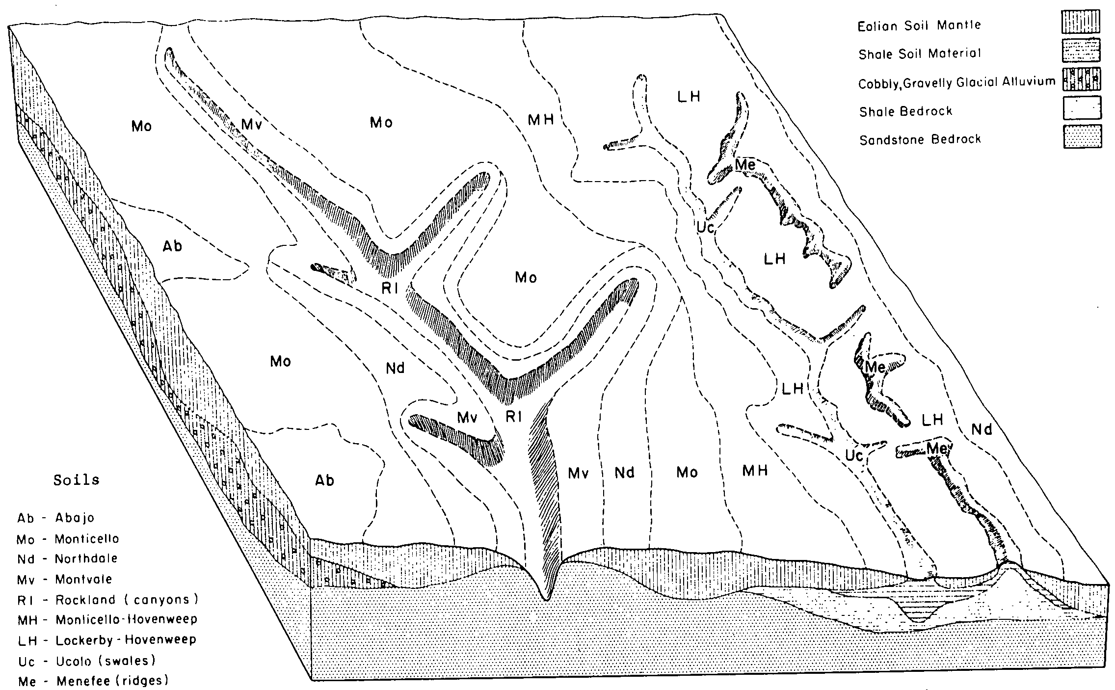
Menefee clay loam, 5 to 35 percent slopes | 129 | 9783 | 56329 | 1wm2 | nm656 | 1987 | 1:24000 |
Rock outcrop-Atarque-Menefee complex, 5 to 25 percent slopes | 324 | 7190 | 56400 | 1wpc | nm656 | 1987 | 1:24000 |
Atarque-Menefee-Rock outcrop complex, 25 to 45 percent slopes | 396 | 5797 | 56411 | 1wpq | nm656 | 1987 | 1:24000 |
Badland-Menefee complex, 15 to 35 percent slopes | 105 | 3210 | 56318 | 1wlq | nm656 | 1987 | 1:24000 |
Rock outcrop-Vessilla-Menefee complex, 30 to 40 percent slopes | 220 | 2390 | 56360 | 1wn2 | nm656 | 1987 | 1:24000 |
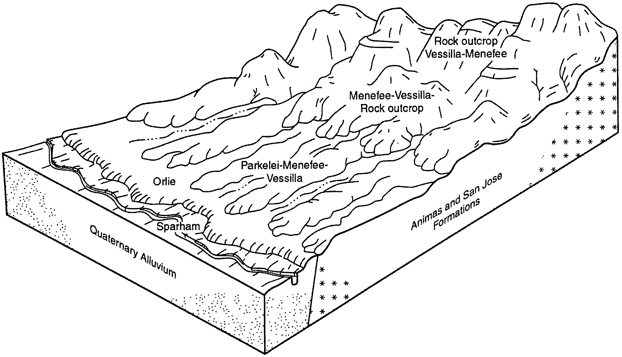
Parkelei-Menefee-Vessilla complex, 2 to 20 percent slopes | PmF | 4690 | 2721372 | 2tdl8 | nm672 | | 1:24000 |
Vessilla-Menefee-Orlie complex, 1 to 30 percent slopes | VoE | 2075 | 2770170 | 2vd1r | nm672 | | 1:24000 |
Rock outcrop-Vessilla-Menefee complex, 15 to 45 percent slopes | RmF | 1988 | 2770197 | 2v5pm | nm672 | | 1:24000 |
Teequee-Menefee-Vessilla complex, 5 to 40 percent slopes | TqE | 608 | 2770205 | 2v5px | nm672 | | 1:24000 |
Menefee-Vessilla-Rock outcrop complex, 5 to 35 percent slopes | MrE | 157 | 2770196 | 2wljg | nm672 | | 1:24000 |
Pinitos-Menefee-Vessilla complex, 2 to 20 percent slopes | PvE | 50 | 2770150 | 2tl8p | nm672 | | 1:24000 |
Pinitos-Menefee-Vessilla complex, 2 to 20 percent slopes | PvE | 1699 | 2934622 | 2tl8p | nm678 | | 1:24000 |
Menefee-Vessilla-Rock outcrop complex, 5 to 35 percent slopes | MvE | 1579 | 2934568 | 2wljg | nm678 | | 1:24000 |
Menefee clay loam, 5 to 35 percent slopes | MqE | 807 | 2934566 | 2wl1m | nm678 | | 1:24000 |
Atarque-Menefee-Ribera complex, 3 to 25 percent slopes | AtE | 772 | 2942525 | 2wljx | nm678 | | 1:24000 |
Uva-Menefee families-Rock outcrop complex, 3 to 40 percent slopes | PE9 | 314 | 2942537 | 2wlk8 | nm678 | | 1:24000 |
Badland-Menefee complex, 15 to 35 percent slopes | BmF | 213 | 2934446 | 2whhz | nm678 | | 1:24000 |
Menefee-Maraita-Wauquie families complex, 5 to 40 percent slopes | PE6 | 195 | 2942559 | 2wll3 | nm678 | | 1:24000 |
Menefee-Nalivag complex, 8 to 25 percent slopes | MnE | 160 | 2934567 | 2wl1n | nm678 | | 1:24000 |
Vessilla-Menefee-Rock outcrop complex, 3 to 15 percent slopes | VeC | 156 | 2942495 | 2wlhl | nm678 | | 1:24000 |
Rock outcrop-Vessilla-Menefee complex, 15 to 45 percent slopes | RvF | 147 | 2942454 | 2v5pm | nm678 | | 1:24000 |
Atarque-Menefee-Rock outcrop complex, 25 to 45 percent slopes | AtG | 127 | 2721110 | 2whhs | nm678 | | 1:24000 |
Parkelei-Menefee-Vessilla complex, 2 to 20 percent slopes | PmF | 68 | 2934611 | 2tdl8 | nm678 | | 1:24000 |
Rock outcrop-Atarque-Menefee complex, 5 to 25 percent slopes | RaE | 20 | 2942445 | 2wl45 | nm678 | | 1:24000 |
Menefee channery loam, 2 to 35 percent slopes | MfD | 8 | 2934565 | 2wl1l | nm678 | | 1:24000 |
Parkelei-Menefee-Vessilla complex, 2 to 20 percent slopes | 40 | 93321 | 57485 | 1xtc | nm698 | 2000 | 1:24000 |
Rock outcrop-Vessilla-Menefee complex, 15 to 45 percent slopes | 310 | 49503 | 57495 | 1xtp | nm698 | 2000 | 1:24000 |
Menefee-Vessilla-Rock outcrop complex, 5 to 35 percent slopes | 20 | 34830 | 57484 | 2wljg | nm698 | 2000 | 1:24000 |
Vessilla-Menefee-Orlie complex, 1 to 30 percent slopes | 155 | 20618 | 57489 | 2vd1r | nm698 | 2000 | 1:24000 |
Teequee-Menefee-Vessilla complex, 5 to 40 percent slopes | 380 | 15716 | 57526 | 1xvp | nm698 | 2000 | 1:24000 |
Horselake-Menefee complex, 3 to 25 percent slopes | 531 | 13696 | 57523 | 1xvl | nm698 | 2000 | 1:24000 |
Badland-Menefee-Rock outcrop complex, 35 to 65 percent slopes | 21 | 11908 | 57510 | 1xv5 | nm698 | 2000 | 1:24000 |
Menefee channery loam, 2 to 35 percent slopes | 115 | 6796 | 57536 | 1xw0 | nm698 | 2000 | 1:24000 |
Badland-Menefee complex, 15 to 35 percent slopes | 105 | 2752 | 57488 | 1xtg | nm698 | 2000 | 1:24000 |
Menefee-Espiritu-Rock outcrop complex, 35 to 75 percent slopes | 418 | 6077 | 57429 | 1xrk | nm717 | 1993 | 1:24000 |
Highdye-Menefee association, 5 to 35 percent slopes | 412 | 4519 | 57423 | 1xrc | nm717 | 1993 | 1:24000 |
Welring-Menefee-Rock outcrop complex, 40 to 80 percent slopes | 510 | 5908 | 484056 | j7pq | ut634 | 1997 | 1:24000 |
Menefee Taxadjunct-Tuces Family-Chinmoe complex, 5 to 45 percent slopes | 690257 | 110 | 3241233 | 2vb15 | ut634 | 1997 | 1:24000 |
Metuck family-Menefee complex, 15 to 50 percent slopes | 5083 | 2 | 3450444 | 3197k | ut636 | 1984 | 1:24000 |
Menefee clay loam, 2 to 25 percent slopes | MfG | 14379 | 55514 | 1vrs | ut639 | 1960 | 1:31680 |
Menefee cobbly clay loam, 4 to 40 percent slopes | MfGC | 2693 | 55515 | 1vrt | ut639 | 1960 | 1:31680 |
Menefee shaley clay loam, 2 to 25 percent slopes | MfGF | 619 | 55516 | 1vrv | ut639 | 1960 | 1:31680 |
Lockerby and Menefee soils, 2 to 10 percent slopes | LMD | 524 | 55511 | 1vrp | ut639 | 1960 | 1:31680 |
Menefee-Rock outcrop complex, 25 to 60 percent slopes | MEG | 7266 | 484768 | j8fp | ut641 | 1971 | 1:24000 |
Colskel-Menefee complex, 15 to 50 percent slopes | 5083 | 35022 | 59845 | 208h | ut686 | 2004 | 1:24000 |
Colskel-Menefee-Arabrab complex, 2 to 15 percent slopes | 5082 | 18850 | 59844 | 208g | ut686 | 2004 | 1:24000 |
Menefee-Badland, Kaiparowits Formation, complex, 5 to 30 percent slopes | 5133 | 2551 | 59860 | 208z | ut686 | 2004 | 1:24000 |
Menefee Taxadjunct-Tuces Family-Chinmoe complex, 5 to 45 percent slopes | 690257 | 2042 | 2855898 | 2vb15 | ut690 | | 1:24000 |


