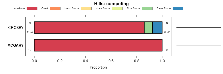
| McGary silt loam, 0 to 2 percent slope | 173A | 772 | 175435 | 2yp53 | il047 | 1967 | 1:15840 |
McGary silt loam, 5 to 10 percent slopes, eroded | 173C2 | 408 | 175437 | 2yp50 | il047 | 1967 | 1:15840 |
McGary silt loam, 2 to 5 percent slopes, eroded | 173B2 | 387 | 175436 | 2yp51 | il047 | 1967 | 1:15840 |
McGary soils, 4 to 10 percent slopes, severely eroded | 173C3 | 132 | 175438 | 5wk9 | il047 | 1967 | 1:15840 |
McGary silt loam, 0 to 2 percent slope | 173A | 4097 | 211607 | 2yp53 | il059 | 1966 | 1:20000 |
McGary silt loam, 2 to 5 percent slopes | 173B | 730 | 211608 | 2yp52 | il059 | 1966 | 1:20000 |
McGary silt loam, 2 to 5 percent slopes, eroded | 173B2 | 447 | 211609 | 2yp51 | il059 | 1966 | 1:20000 |
McGary silt loam, 5 to 10 percent slopes, eroded | 173C2 | 127 | 211610 | 2yp50 | il059 | 1966 | 1:20000 |
McGary silt loam, 0 to 3 percent slopes | 173A | 615 | 175125 | 5w76 | il065 | 1982 | 1:15840 |
McGary silt loam, 0 to 2 percent slope | 173A | 2098 | 176676 | 2yp53 | il101 | 1952 | 1:42240 |
McGary silt loam, 2 to 5 percent slopes, eroded | 173B2 | 399 | 176678 | 2yp51 | il101 | 1952 | 1:42240 |
McGary silt loam, 2 to 5 percent slopes | 173B | 322 | 176677 | 2yp52 | il101 | 1952 | 1:42240 |
McGary silt loam, 4 to 7 percent slopes, severely eroded | 173C3 | 272 | 176680 | 5xvc | il101 | 1952 | 1:42240 |
McGary silt loam, 5 to 10 percent slopes, eroded | 173C2 | 121 | 176679 | 2yp50 | il101 | 1952 | 1:42240 |
McGary silt loam, 0 to 2 percent slope | 173A | 2561 | 178865 | 2yp53 | il165 | 1974 | 1:15840 |
McGary silt loam, 0 to 2 percent slope | 173A | 2153 | 179634 | 2yp53 | il185 | 1962 | 1:20000 |
McGary silt loam, 2 to 5 percent slopes, eroded | 173B2 | 237 | 179636 | 2yp51 | il185 | 1962 | 1:20000 |
McGary silt loam, 2 to 5 percent slopes | 173B | 188 | 179635 | 2yp52 | il185 | 1962 | 1:20000 |
McGary silt loam, 5 to 10 percent slopes, eroded | 173C2 | 65 | 179637 | 2yp50 | il185 | 1962 | 1:20000 |
McGary silt loam, 0 to 2 percent slopes, rarely flooded | 7173A | 4018 | 1543957 | 1ntm2 | il193 | 2006 | 1:12000 |
McGary silt loam, 0 to 2 percent slope | 173A | 812 | 1543880 | 2yp53 | il193 | 2006 | 1:12000 |
McGary silt loam, 2 to 5 percent slopes, eroded, rarely flooded | 7173B2 | 547 | 1543958 | 1ntm3 | il193 | 2006 | 1:12000 |
McGary silt loam, 2 to 5 percent slopes, eroded | 173B2 | 227 | 1543881 | 2yp51 | il193 | 2006 | 1:12000 |
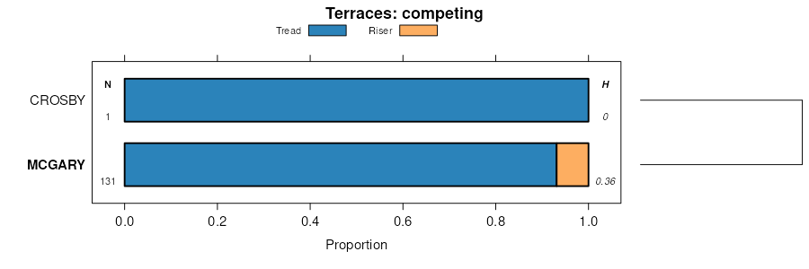
McGary silt loam, 0 to 2 percent slopes | MhuA | 197 | 195571 | 6khr | in005 | 2002 | 1:12000 |
McGary silt loam, 0 to 2 percent slopes | MhuA | 375 | 210842 | 2wlvf | in019 | 2001 | 1:12000 |
McGary silt loam, 0 to 2 percent slope | Mg | 422 | 162961 | 2yp53 | in027 | 1969 | 1:20000 |
McGary silt loam, 0 to 2 percent slope | MgA | 322 | 535631 | 2yp53 | in037 | 1978 | 1:15840 |
McGary silt loam, 0 to 2 percent slopes | MhuA | 18 | 185264 | 2wlvf | in043 | 2000 | 1:12000 |
McGary silt loam, 0 to 2 percent slope | MgA | 629 | 161556 | 2yp53 | in055 | 1984 | 1:15840 |
McGary silt loam, 0 to 2 percent slopes | MhuA | 131 | 775596 | 2wlvf | in061 | 2007 | 1:12000 |
McGary silty clay loam, 0 to 2 percent slopes | MikA | 662 | 1907079 | 220gp | in071 | 1985 | 1:15840 |
McGary silt loam, 0 to 2 percent slope | McA | 785 | 164494 | 2yp53 | in083 | 1979 | 1:15840 |
McGary silty clay loam, 0 to 2 percent slopes, frequently flooded, brief duration | MikAH | 1570 | 1651543 | 1sfkl | in093 | 1982 | 1:15840 |
McGary silty clay loam, 0 to 2 percent slopes, rarely flooded | MikAQ | 344 | 1443091 | 1kfnb | in101 | 1984 | 1:15840 |
McGary silty clay loam, 0 to 2 percent slopes | MikA | 128 | 1708144 | 1vbgf | in101 | 1984 | 1:15840 |
McGary silt loam, 0 to 2 percent slopes | MhuA | 322 | 166145 | 5kwj | in119 | 1997 | 1:12000 |
McGary silt loam, 0 to 2 percent slopes | MhuA | 907 | 535825 | 2wlvf | in123 | 1997 | 1:12000 |
McGary silty clay loam, 0 to 2 percent slopes | MgA | 470 | 161921 | 5fh8 | in125 | 1983 | 1:15840 |
McGary silt loam, 0 to 2 percent slope | Mr | 3756 | 160037 | 2yp53 | in147 | 1966 | 1:15840 |
McGary silt loam, 0 to 2 percent slope | Mg | 607 | 162695 | 2yp53 | in153 | 1966 | 1:15840 |
McGary silt loam, 0 to 2 percent slope | Mr | 2937 | 162757 | 2yp53 | in163 | 1972 | 1:15840 |
McGary silt loam, 0 to 2 percent slope | MrA | 6716 | 159963 | 2yp53 | in173 | 1976 | 1:15840 |
McGary silt loam, 0 to 2 percent slopes | MgA | 730 | 535494 | kz70 | in175 | 1984 | 1:15840 |
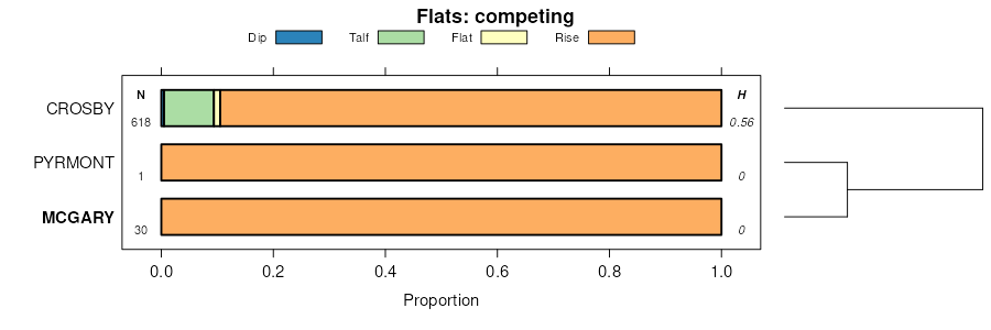
McGary silt loam, frequently flooded | Mg | 439 | 1404761 | 1j4rw | ky033 | 2005 | 1:12000 |
McGary silt loam | Mc | 1370 | 550249 | lgkz | ky043 | 1980 | 1:20000 |
McGary silty clay loam, occasionally flooded | Mc | 2236 | 549123 | lfdn | ky055 | 1985 | 1:20000 |
McGary silt loam | Ma | 850 | 552718 | lk4m | ky069 | 1989 | 1:20000 |
McGary silt loam, 0 to 2 percent slopes, rarely flooded | Ml | 515 | 549209 | 2vtzt | ky101 | 1964 | 1:15840 |
McGary silt loam, 0 to 2 percent slopes, rarely flooded | Mg | 4888 | 549282 | 2vtzt | ky107 | 1974 | 1:12000 |
McGary loam, loamy subsoil variant | Mh | 502 | 549283 | lfkt | ky107 | 1974 | 1:12000 |
McGary silt loam | Mc | 1306 | 550308 | lgmw | ky135 | 1998 | 1:20000 |
McGary silt loam, 0 to 2 percent slopes, rarely flooded | Mc | 4017 | 549335 | 2wlvs | ky139 | 1989 | 1:20000 |
McGary silt loam, 0 to 2 percent slopes, rarely flooded | Mr | 2125 | 549982 | 2wlvg | ky179 | 1967 | 1:15840 |
McGary silt loam, 0 to 2 percent slopes, rarely flooded | Mc | 808 | 551262 | 2vtzt | ky183 | 1983 | 1:20000 |
McGary silt loam, 0 to 2 percent slopes | Mc | 270 | 551662 | 2wlvd | ky211 | 1978 | 1:20000 |
McGary silt loam | Mm | 676 | 550409 | lgr4 | ky605 | 1975 | 1:20000 |
McGary silt loam, 0 to 2 percent slopes | Mg | 385 | 551556 | 2wlvd | ky606 | 1979 | 1:20000 |
McGary silt loam, 0 to 2 percent slopes, rarely flooded | Mc | 946 | 549599 | 2vtzt | ky607 | 1992 | 1:20000 |
McGary silt loam, 0 to 2 percent slopes, rarely flooded | Mc | 15718 | 551001 | 2wlvg | ky608 | 1983 | 1:20000 |
McGary variant silt loam, rarely flooded | Mv | 482 | 551003 | lhc9 | ky608 | 1983 | 1:20000 |
McGary silt loam | Mc | 2026 | 552001 | ljdh | ky612 | 1972 | 1:15840 |
McGary silt loam, 0 to 2 percent slopes, rarely flooded | Mc | 2699 | 549401 | 2vtzt | ky615 | 1971 | 1:20000 |
McGary silt loam, 0 to 2 percent slopes | Mc | 766 | 551966 | 2wlvd | ky619 | 1978 | 1:15840 |
McGary silt loam, 0 to 2 percent slopes, rarely flooded | Mr | 4880 | 551051 | 2wlvg | ky621 | 1975 | 1:20000 |
McGary silt loam, 0 to 2 percent slopes | Mc | 127 | 551927 | 2wlvd | ky622 | 1989 | 1:20000 |
McGary silt loam, 0 to 2 percent slopes, rarely flooded | Mc | 11153 | 551114 | 2vtzt | ky631 | 1976 | 1:20000 |
McGary silt loam, 0 to 2 percent slopes, rarely flooded | Mg | 10209 | 549517 | 2wlvs | ky635 | 1978 | 1:20000 |
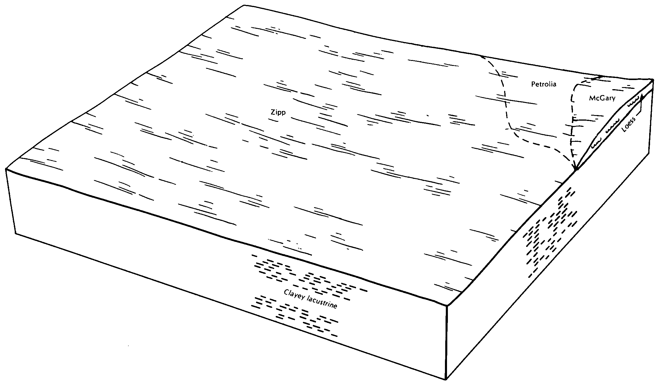
McGary silt loam, 0 to 3 percent slopes | McA | 750 | 537371 | l15k | oh009 | 1981 | 1:15840 |
McGary silt loam, 0 to 4 percent slopes | McA | 606 | 169690 | 5pkw | oh011 | 1979 | 1:15840 |
McGary silty clay loam, 0 to 2 percent slopes | MdA | 8 | 1146246 | 17grp | oh011 | 1979 | 1:15840 |
McGary silt loam, 0 to 2 percent slopes | MgA | 47 | 168803 | 5nn8 | oh025 | 1972 | 1:20000 |
McGary silt loam, 2 to 6 percent slopes | McB | 759 | 172282 | 5s8h | oh045 | 1998 | 1:12000 |
McGary silt loam, 1 to 6 percent slopes | McB | 405 | 536823 | l0lw | oh053 | 1988 | 1:15840 |
McGary silt loam, 0 to 3 percent slopes | McA | 629 | 536929 | l0q9 | oh059 | 1998 | 1:15840 |
McGary silt loam, 0 to 4 percent slopes | MgB | 278 | 1420463 | 1jp3d | oh071 | 1973 | 1:15840 |
McGary silt loam, 0 to 3 percent slopes | McA | 367 | 1398083 | 1hxtg | oh073 | 1986 | 1:15840 |
McGary silt loam, 0 to 4 percent slopes | MgA | 83 | 1460518 | 1l0sh | oh079 | 1981 | 1:15840 |
McGary silty clay loam, 0 to 2 percent slopes | MfA | 21 | 1460498 | 1l0rv | oh079 | 1981 | 1:15840 |
McGary silt loam, 0 to 2 percent slopes | MdA | 20 | 1460523 | 1l0sn | oh079 | 1981 | 1:15840 |
McGary silt loam, 0 to 2 percent slopes | McA | 122 | 536157 | kzxd | oh087 | 1989 | 1:15840 |
McGary silt loam, 0 to 4 percent slopes | MeA | 21 | 1593175 | 1qgtr | oh091 | 1977 | 1:15840 |
McGary silty clay loam, 0 to 2 percent slopes | McA | 1992 | 169940 | 5pty | oh107 | 1975 | 1:15840 |
McGary silty clay loam, 2 to 6 percent slopes | McB | 1352 | 169941 | 5ptz | oh107 | 1975 | 1:15840 |
McGary silt loam, 0 to 3 percent slopes | MdA | 688 | 537916 | l1r4 | oh119 | 1989 | 1:15840 |
McGary silt loam, 0 to 4 percent slopes | MkA | 1407 | 537662 | l1gy | oh131 | 1984 | 1:15840 |
McGary silt loam, 0 to 2 percent slopes | MdA | 21 | 1689007 | 1tpk3 | oh131 | 1984 | 1:15840 |
McGary silt loam, 0 to 2 percent slopes | MdA | 429 | 170906 | 5qv3 | oh141 | 1997 | 1:15840 |
McGary silt loam, 2 to 6 percent slopes | MdB | 135 | 170907 | 5qv4 | oh141 | 1997 | 1:15840 |
McGary silt loam | Mc | 84 | 168095 | 5mxf | oh161 | 1967 | 1:15840 |
McGary silty clay loam, 0 to 2 percent slopes | McA | 180 | 536410 | l05k | oh163 | 1998 | 1:15840 |
McGary silt loam, 0 to 2 percent slopes | McA | 312 | 536529 | l09d | oh167 | 1973 | 1:15840 |
McGary silty clay loam | 24 | 950 | 516529 | kbh7 | va043 | 1980 | 1:15840 |
McGary and Purdy soils | 25 | 2505 | 517097 | kc2k | va121 | 1980 | 1:15840 |
Shircliff-McGary complex, 3 to 8 percent slopes | SxB | 1626 | 1384151 | 1hgb1 | wv600 | 2005 | 1:24000 |
McGary-Shircliff complex, 0 to 3 percent slopes | McA | 484 | 1384150 | 1hgb0 | wv600 | 2005 | 1:24000 |
McGary silty clay loam | Mg | 1818 | 514615 | k8hh | wv601 | 1966 | 1:15840 |