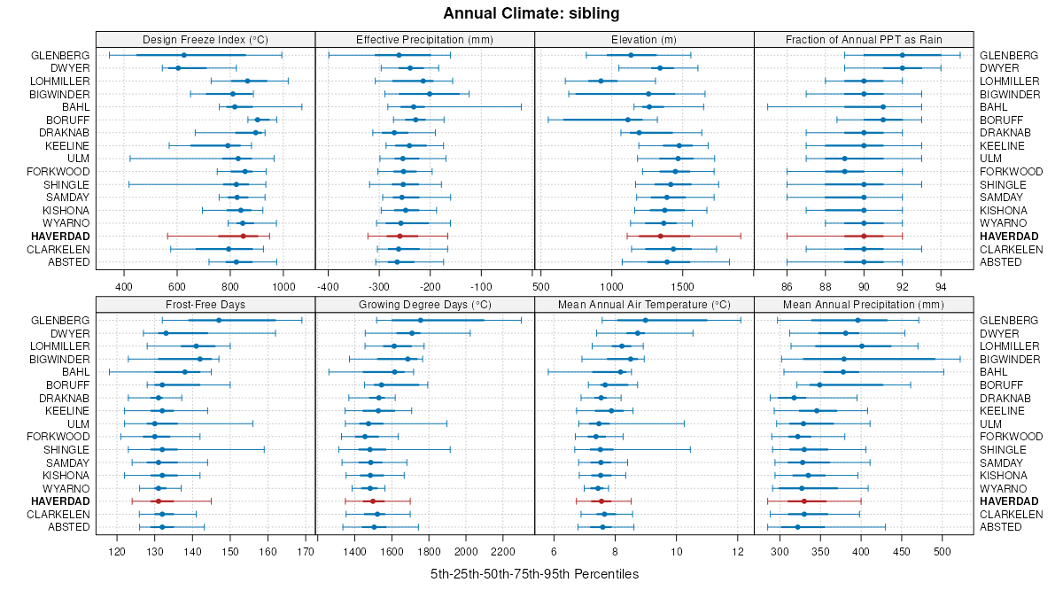
| Haverdad clay loam, 0 to 3 percent slopes | 284 | 136 | 1387764 | 1hl2l | mt643 | 1967 | 1:20000 |
Haverdad loam, alkali, 0 to 3 percent slopes | 49 | 10073 | 503741 | jx5q | ut616 | 1983 | 1:24000 |
Haverdad loam, moist, 1 to 5 percent slopes | 50 | 9743 | 503743 | jx5s | ut616 | 1983 | 1:24000 |
Haverdad loam, 1 to 8 percent slopes | 48 | 6459 | 503740 | jx5p | ut616 | 1983 | 1:24000 |
Haverdad silt loam | 40 | 15018 | 55168 | 1vdm | ut631 | 1982 | 1:24000 |
Haverdad loam, 0 to 3 percent slopes | 254 | 177 | 780261 | v5xq | wy011 | 1978 | 1:24000 |
Clarkelen-Haverdad complex, 0 to 3 percent slopes, rarely flooded | 137 | 24102 | 349588 | 2yv6y | wy027 | 1993 | 1:24000 |
Haverdad loam, overflow, 0 to 4 percent slopes | 136 | 10828 | 349586 | cqrz | wy027 | 1993 | 1:24000 |
Haverdad-Clarkelen complex, saline, 0 to 3 percent slopes | 138 | 4848 | 349590 | cqs3 | wy027 | 1993 | 1:24000 |
Lohmiller-Haverdad complex, saline, 1 to 4 percent slopes | 159 | 465 | 349632 | cqtg | wy027 | 1993 | 1:24000 |
Coaliams-Haverdad complex, 0 to 3 percent slopes | 135 | 24813 | 104492 | 3hqq | wy031 | 1998 | 1:24000 |
Forkwood-Kishona association | 22 | 62777 | 152066 | 537c | wy043 | 1976 | 1:24000 |
Forkwood-Haverdad association | 21 | 29732 | 152065 | 537b | wy043 | 1976 | 1:24000 |
Haverdad-Clarkelen complex, 0 to 4 percent slopes | 46 | 32113 | 349450 | cqml | wy045 | 1984 | 1:24000 |
Lohmiller-Haverdad complex, saline, 1 to 4 percent slopes | 60 | 20131 | 349466 | cqn3 | wy045 | 1984 | 1:24000 |
Lohmiller-Haverdad complex, 1 to 4 percent slopes | 59 | 7792 | 349464 | cqn1 | wy045 | 1984 | 1:24000 |
Haverdad-Clarkelen variant complex, saline, 0 to 4 percent slopes | 47 | 5232 | 349451 | cqmm | wy045 | 1984 | 1:24000 |
Haverdad-Clarkelen complex, saline, 0 to 3 percent slopes | 156 | 160 | 1614841 | 1r6cn | wy045 | 1984 | 1:24000 |
Haverdad loam, overflow, 0 to 4 percent slopes | 166 | 155 | 1650251 | 1sd6x | wy045 | 1984 | 1:24000 |
Haverdad, occasionally flooded-Kishona clay loams, 0 to 6 percent slopes | 153 | 11770 | 349840 | 2ztzd | wy605 | 1995 | 1:24000 |
Haverdad loam, 0 to 3 percent slopes | 151 | 9753 | 349836 | cr11 | wy605 | 1995 | 1:24000 |
Haverdad-Clarkelen complex, 0 to 4 percent slopes | 152 | 2082 | 349838 | cr13 | wy605 | 1995 | 1:24000 |
Haverdad-Clarkelen complex, wet, 0 to 3 percent slopes | 167 | 9497 | 1669827 | 1t1ld | wy609 | 2006 | 1:24000 |
Clarkelen-Haverdad complex, 0 to 3 percent slopes, rarely flooded | 165 | 6880 | 1669691 | 2yv6y | wy609 | 2006 | 1:24000 |
Haverdad loam, wet, 0 to 3 percent slopes | 164 | 5523 | 1669693 | 1t1g2 | wy609 | 2006 | 1:24000 |
Haverdad loam, 0 to 3 percent slopes | 162 | 3916 | 1669828 | 1t1lf | wy609 | 2006 | 1:24000 |
Clarkelen, wet-Haverdad, wet-Bigwinder complex, 0 to 3 percent slopes | 125 | 1869 | 1669825 | 1t1lb | wy609 | 2006 | 1:24000 |
Haverdad-Lohmiller complex, 0 to 6 percent slopes, rarely flooded | 168 | 830 | 1669692 | 2wlrw | wy609 | 2006 | 1:24000 |
Clarkelen-Bigwinder-Haverdad complex, 0 to 3 percent slopes, rarely flooded | 129 | 615 | 1669671 | 2yv79 | wy609 | 2006 | 1:24000 |
Haverdad loam, overflow, 0 to 4 percent slopes | 163 | 55 | 1669813 | 1t1ky | wy609 | 2006 | 1:24000 |
Haverdad-Clarkelen complex, overflow, 0 to 3 percent slopes | 166 | 13 | 1669807 | 1t1kr | wy609 | 2006 | 1:24000 |
Haverdad-Clarkelen complex, 0 to 4 percent slopes | 152 | 49 | 817240 | wfdl | wy619 | 1971 | 1:24000 |
Haverdad, occasionally flooded-Kishona clay loams, 0 to 6 percent slopes | 153 | 35 | 817241 | 2ztzd | wy619 | 1971 | 1:24000 |
Haverdad-Clarkelen complex, 0 to 3 percent slopes | 103 | 30 | 816585 | wdqg | wy619 | 1971 | 1:24000 |
Haverdad-Clarkelen complex, saline, 0 to 3 percent slopes | 195 | 6 | 816721 | wdvv | wy619 | 1971 | 1:24000 |
Haverdad-Clarkelen complex, saline, 0 to 3 percent slopes | 195 | 42386 | 502283 | jvnp | wy625 | 1985 | 1:24000 |
Haverdad-Clarkelen complex, 0 to 3 percent slopes | 194 | 20455 | 502282 | jvnn | wy625 | 1985 | 1:24000 |
Haverdad loam, 0 to 4 percent slopes | 193 | 1156 | 502281 | jvnm | wy625 | 1985 | 1:24000 |
Clarkelen-Bigwinder-Haverdad complex, 0 to 3 percent slopes, rarely flooded | 324 | 19 | 1421365 | 2yv79 | wy625 | 1985 | 1:24000 |
Haverdad-Lohmiller complex, 0 to 6 percent slopes, rarely flooded | 330 | 7 | 1426088 | 2wlrw | wy625 | 1985 | 1:24000 |
Haverdad clay loam, 3 to 6 percent slopes -- Draft | 33B | 3990 | 152522 | 53q2 | wy629 | | 1:24000 |
Haverdad clay loam, 0 to 3 percent slopes -- Draft | 33A | 47 | 152521 | 53q1 | wy629 | | 1:24000 |
Shingle-Haverdad, frequently flooded complex, 0 to 80 percent slopes | 255 | 9160 | 360997 | d3n2 | wy633 | 1987 | 1:24000 |
Haverdad-Draknab complex, 0 to 3 percent slopes | 158 | 6510 | 361149 | d3sz | wy633 | 1987 | 1:24000 |
Haverdad very fine sandy loam, 0 to 3 percent slopes | 154 | 5170 | 361145 | d3sv | wy633 | 1987 | 1:24000 |
Haverdad, moist-Worthenton complex, 0 to 3 percent slopes | 161 | 4478 | 361158 | d3t8 | wy633 | 1987 | 1:24000 |
Shingle-Haverdad association, moist, 0 to 80 percent slopes | 256 | 4379 | 360996 | d3n1 | wy633 | 1987 | 1:24000 |
Haverdad-Worthenton complex, 0 to 3 percent slopes | 160 | 3846 | 361159 | d3t9 | wy633 | 1987 | 1:24000 |
Absted-Haverdad association, moist, 0 to 6 percent slopes | 102 | 3487 | 339847 | cdmt | wy633 | 1987 | 1:24000 |
Haverdad-Draknab complex, moist, 0 to 3 percent slopes | 159 | 2623 | 361141 | d3sq | wy633 | 1987 | 1:24000 |
Haverdad loam, moist, 0 to 3 percent slopes | 155 | 2469 | 361144 | d3st | wy633 | 1987 | 1:24000 |
Absted-Haverdad, rarely flooded very fine sandy loams, 0 to 6 percent slopes | 101 | 1798 | 339845 | cdmr | wy633 | 1987 | 1:24000 |
Haverdad-Boruff complex, 0 to 6 percent slopes, occasionally flooded | 325 | 1165 | 361227 | d3wh | wy633 | 1987 | 1:24000 |
Haverdad loam, moist, saline, 0 to 3 percent slopes | 157 | 933 | 361142 | d3sr | wy633 | 1987 | 1:24000 |
Haverdad silt loam, saline, 0 to 3 percent slopes | 156 | 570 | 361143 | d3ss | wy633 | 1987 | 1:24000 |
Clarkelen-Haverdad complex, 0 to 3 percent slopes, rarely flooded | 649 | 12 | 2389975 | 2yv6y | wy633 | 1987 | 1:24000 |
Haverdad-Boruff complex, 0 to 3 percent slopes, occasionally flooded | 285 | 6282 | 817620 | wfsv | wy705 | 2003 | 1:24000 |
Haverdad clay loam, 0 to 3 percent slopes | 284 | 1131 | 817626 | wft1 | wy705 | 2003 | 1:24000 |
Haverdad loam, 0 to 3 percent slopes | 151 | 42 | 817536 | wfq4 | wy705 | 2003 | 1:24000 |
Haverdad-Lohmiller complex, 0 to 6 percent slopes, rarely flooded | 120 | 20662 | 351498 | 2wlrw | wy709 | 1983 | 1:24000 |
Clarkelen-Bigwinder-Haverdad complex, 0 to 3 percent slopes, rarely flooded | 109 | 13794 | 351487 | 2yv79 | wy709 | 1983 | 1:24000 |
Haverdad loam, overflow, 0 to 4 percent slopes | 228 | 541 | 1427846 | 1jxsk | wy709 | 1983 | 1:24000 |
Lohmiller-Haverdad complex, 1 to 4 percent slopes | 240 | 101 | 1427897 | 1jxv6 | wy709 | 1983 | 1:24000 |
Haverdad loam, 0 to 3 percent slopes | 221 | 32 | 361295 | d3yp | wy709 | 1983 | 1:24000 |
Haverdad-Clarkelen complex, 0 to 3 percent slopes | 156 | 5585 | 503021 | jwfh | wy713 | 1986 | 1:24000 |
Coaliams-Haverdad complex, 0 to 3 percent slopes | 48 | 9 | 1414817 | 1jh78 | wy715 | 1974 | 1:20000 |
Clarkelen-Haverdad complex, 0 to 3 percent slopes, rarely flooded | 649 | 13442 | 1383920 | 2yv6y | wy719 | 2013 | 1:24000 |
Haverdad, occasionally flooded-Kishona clay loams, 0 to 6 percent slopes | 727 | 10135 | 1469312 | 2ztzd | wy719 | 2013 | 1:24000 |
Haverdad, occasionally flooded-Kishona loams, 0 to 3 percent slopes | 613 | 3768 | 1389329 | 1hmq2 | wy719 | 2013 | 1:24000 |
Shingle-Haverdad, frequently flooded complex, 0 to 80 percent slopes | 624 | 3359 | 1604042 | 1qv49 | wy719 | 2013 | 1:24000 |
Haverdad loam, 0 to 3 percent slopes, rarely flooded | 607 | 3099 | 1672817 | 1t4pv | wy719 | 2013 | 1:24000 |
Absted-Haverdad, rarely flooded very fine sandy loams, 0 to 6 percent slopes | 664 | 545 | 1674095 | 1t612 | wy719 | 2013 | 1:24000 |
Haverdad-Boruff complex, 0 to 3 percent slopes, occasionally flooded | 617 | 14 | 1675382 | 1t7cl | wy719 | 2013 | 1:24000 |
Haverdad-Clarkelen-Kovich, warm, complex, 0 to 3 percent slopes | 135 | 1777 | 104936 | 3j61 | wy721 | 1994 | 1:24000 |