| Dekalb stony fine sandy loam, 25 to 60 percent slopes | DuF | 9615 | 531328 | ktwm | ga622 | 1967 | 1:20000 |
Dekalb stony fine sandy loam, 15 to 25 percent slopes | DuE | 5550 | 531327 | ktwl | ga622 | 1967 | 1:20000 |
Dekalb flaggy fine sandy loam, 6 to 15 percent slopes | DtD | 3885 | 531326 | ktwk | ga622 | 1967 | 1:20000 |
Dekalb-Westmoreland-Gilpin complex, 20 to 60 percent slopes, very stony | DwF | 25503 | 1404749 | 1j4rh | ky033 | 2005 | 1:12000 |
Westmoreland-Dekalb-Gilpin complex, 12 to 20 percent slopes, very stony | WgD | 3147 | 1404808 | 1j4td | ky033 | 2005 | 1:12000 |
Rock outcrop-Dekalb-Ramsey complex, very steep | RdF | 2161 | 1404795 | 1j4sz | ky033 | 2005 | 1:12000 |
Dekalb channery sandy loam, 20 to 40 percent slopes | DkF | 4578 | 549049 | lfb8 | ky047 | 1977 | 1:20000 |
Fedscreek-Marrowbone-Dekalb complex, 30 to 80 percent slopes, very stony | FmF | 46249 | 550031 | lgby | ky195 | 1986 | 1:24000 |
Dekalb-Rock outcrop complex, 12 to 20 percent slopes | DrD | 73 | 552394 | ljt5 | ky199 | 1969 | 1:12000 |
Dekalb sandy loam, 6 to 12 percent slopes | DeC | 55 | 552393 | ljt4 | ky199 | 1969 | 1:12000 |
Dekalb-Frondorf-Rock outcrop complex, 20 to 45 percent slopes | DkF | 4950 | 551150 | lhj1 | ky219 | 1984 | 1:20000 |
Gilpin-Dekalb-Rock outcrop complex, 30 to 60 percent slopes | GwF | 26848 | 549586 | lfwl | ky607 | 1992 | 1:20000 |
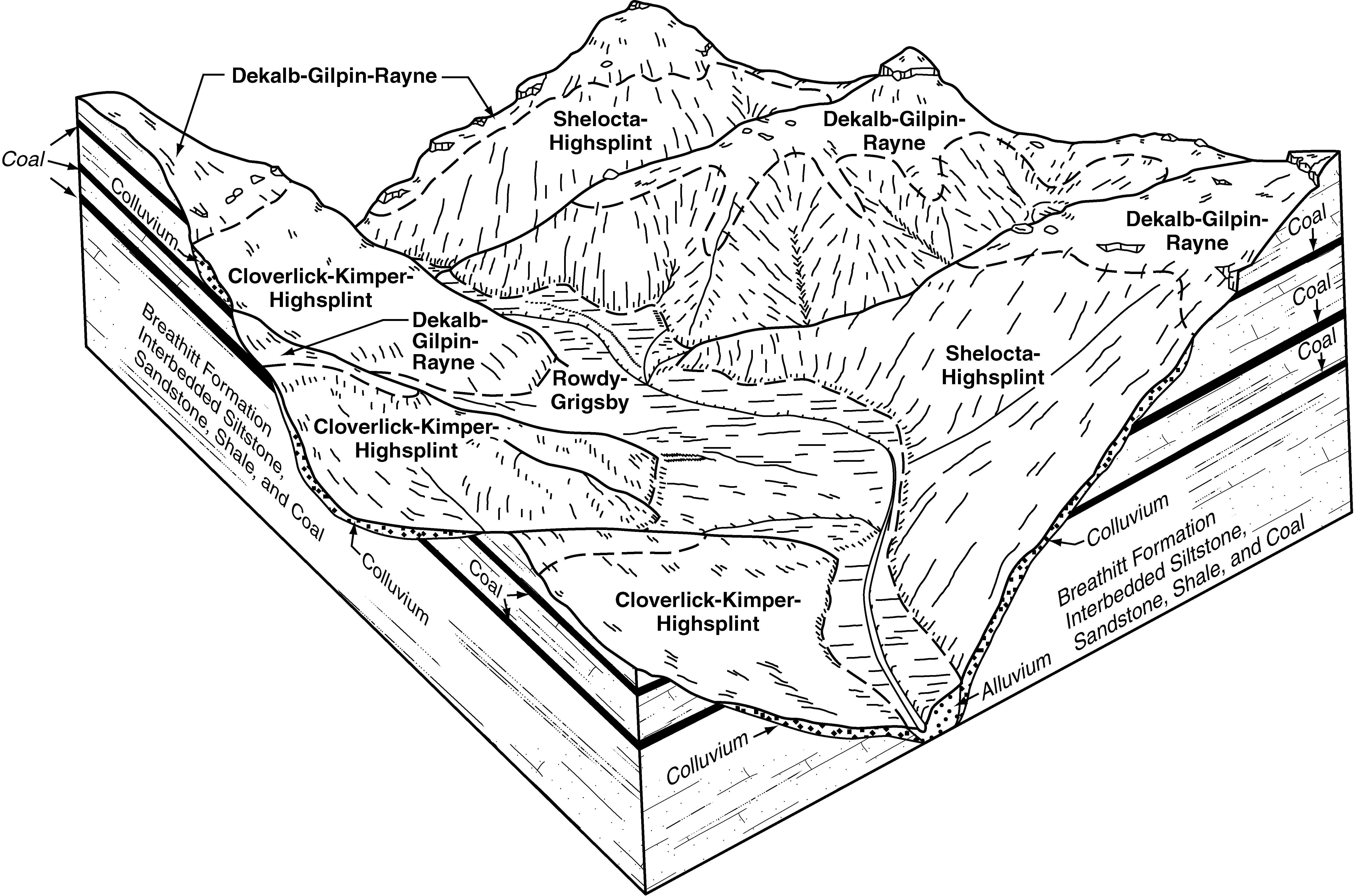
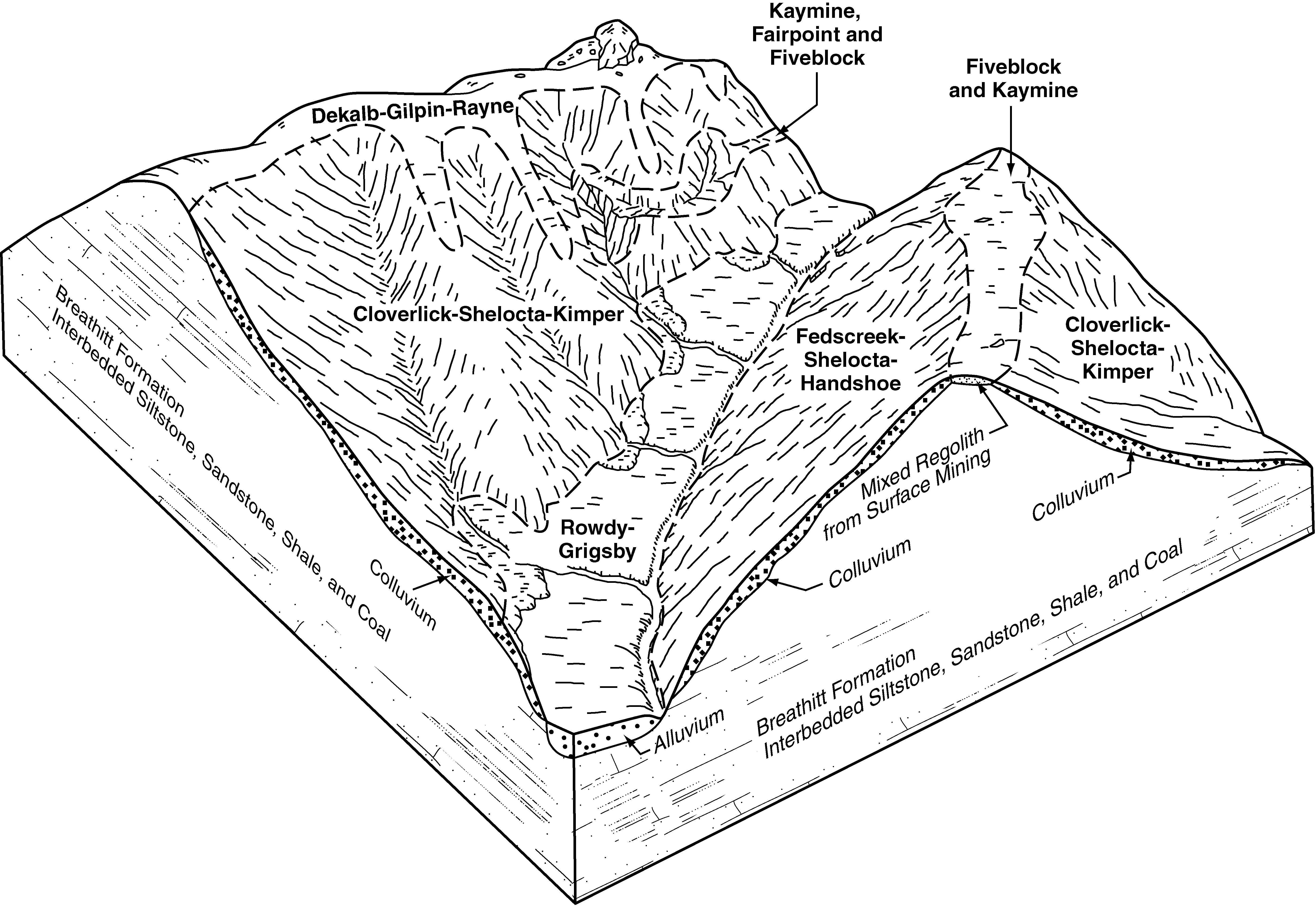
Dekalb-Gilpin-Rayne complex, 25 to 65 percent slopes, very rocky | DrF | 39070 | 550729 | lh2g | ky626 | 1997 | 1:24000 |
Highsplint-Shelocta-Dekalb complex, 35 to 80 percent slopes, very stony | HsF | 1935 | 550738 | lh2r | ky626 | 1997 | 1:24000 |
Latham-Dekalb complex, 30 to 60 percent slopes | LDF | 73177 | 552219 | ljmj | ky627 | 1984 | 1:20000 |
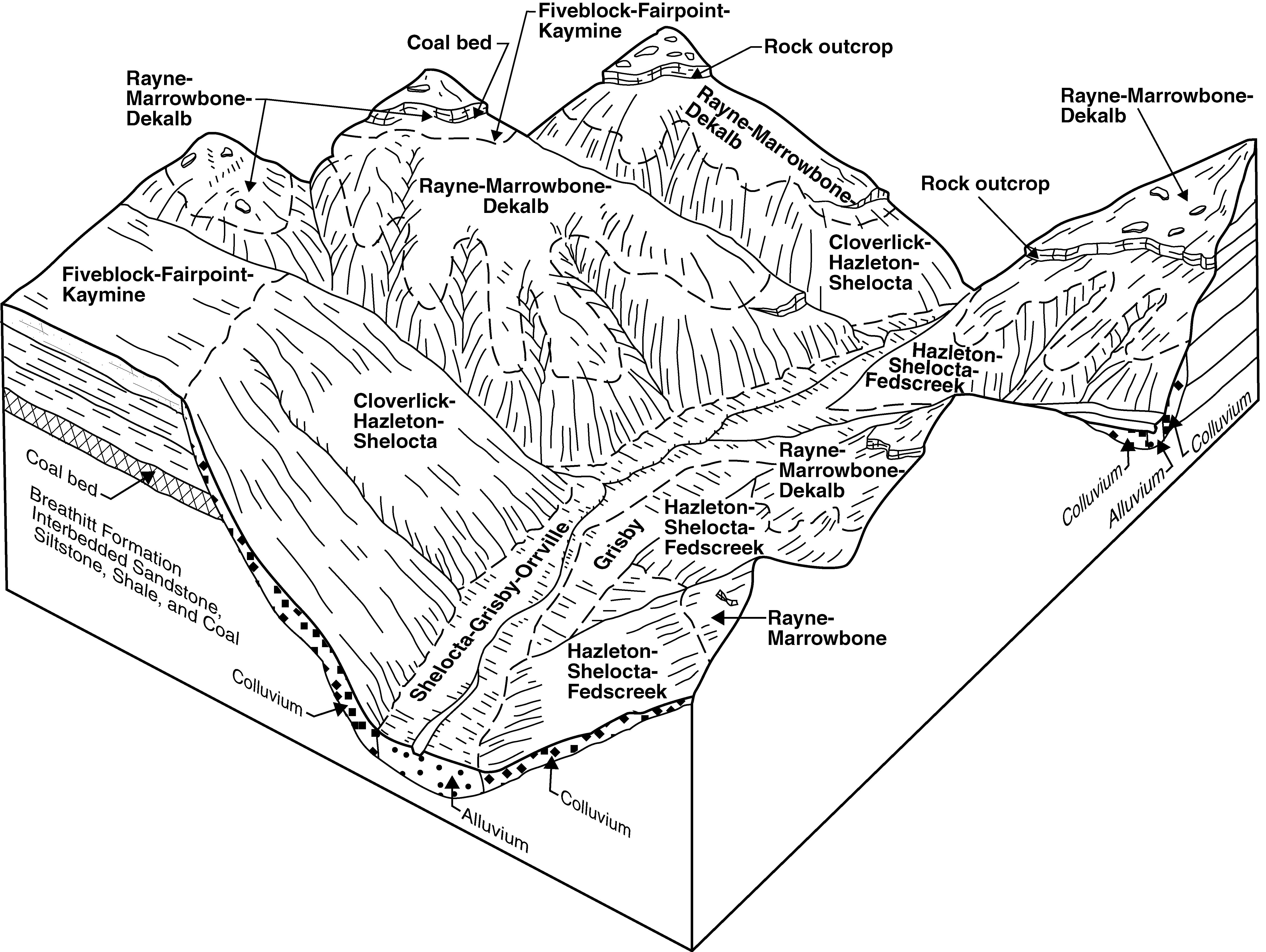
Rayne-Marrowbone-Dekalb complex, 20 to 80 percent slopes, very rocky | RaF | 48755 | 550911 | lh8b | ky640 | 1996 | 1:24000 |
Marrowbone-Blairton-Dekalb complex, 25 to 60 percent slopes, rocky | MaF | 22141 | 550908 | lh87 | ky640 | 1996 | 1:24000 |
Dekalb gravelly sandy loam, 25 to 45 percent slopes, very stony | DbE | 4312 | 2401110 | 2llk5 | md001 | 2009 | 1:12000 |
Dekalb-Rock outcrop complex, 45 to 65 percent slopes, rubbly | DeF | 2669 | 2401115 | 2llkb | md001 | 2009 | 1:12000 |
Dekalb-Rock outcrop complex, 25 to 45 percent slopes, rubbly | DeE | 1731 | 2401114 | 2llk9 | md001 | 2009 | 1:12000 |
Dekalb-Rock outcrop complex, 65 to 80 percent slopes, rubbly | DeG | 1284 | 2401116 | 2llkc | md001 | 2009 | 1:12000 |
Dekalb very cobbly sandy loam, 25 to 45 percent slopes, very rubbly | DcE | 975 | 2401120 | 2llkh | md001 | 2009 | 1:12000 |
Dekalb very cobbly sandy loam, 45 to 65 percent slopes, very rubbly | DcF | 752 | 2401121 | 2llkj | md001 | 2009 | 1:12000 |
Dekalb-Rock outcrop complex, 15 to 25 percent slopes, rubbly | DeD | 517 | 2401113 | 2llk8 | md001 | 2009 | 1:12000 |
Dekalb-Rock outcrop complex, 8 to 15 percent slopes, rubbly | DeC | 477 | 2401112 | 2llk7 | md001 | 2009 | 1:12000 |
Dekalb gravelly sandy loam, 15 to 25 percent slopes, very stony | DbD | 425 | 2401109 | 2llk4 | md001 | 2009 | 1:12000 |
Dekalb gravelly sandy loam, 8 to 15 percent slopes, very stony | DbC | 386 | 2401108 | 2llk3 | md001 | 2009 | 1:12000 |
Dekalb gravelly sandy loam, 45 to 65 percent slopes, very stony | DbF | 223 | 2401111 | 2llk6 | md001 | 2009 | 1:12000 |
Dekalb very cobbly sandy loam, 15 to 25 percent slopes, very rubbly | DcD | 198 | 2401119 | 2llkg | md001 | 2009 | 1:12000 |
Dekalb gravelly sandy loam, 3 to 8 percent slopes, very stony | DbB | 197 | 2401107 | 2llk2 | md001 | 2009 | 1:12000 |
Dekalb very cobbly sandy loam, 8 to 15 percent slopes, very rubbly | DcC | 127 | 2401118 | 2llkf | md001 | 2009 | 1:12000 |
Dekalb gravelly sandy loam, 25 to 45 percent slopes | DaE | 123 | 2401106 | 2llk1 | md001 | 2009 | 1:12000 |
Dekalb-Urban land complex, 8 to 15 percent slopes | DkC | 104 | 2401017 | 2llg5 | md001 | 2009 | 1:12000 |
Dekalb very cobbly sandy loam, 3 to 8 percent slopes, very rubbly | DcB | 60 | 2401117 | 2llkd | md001 | 2009 | 1:12000 |
Dekalb-Urban land complex 15 to 25 percent slopes | DkD | 58 | 2401018 | 2llg6 | md001 | 2009 | 1:12000 |
Dekalb gravelly sandy loam, 8 to 15 percent slopes | DaC | 53 | 2401104 | 2lljz | md001 | 2009 | 1:12000 |
Dekalb gravelly sandy loam, 15 to 25 percent slopes | DaD | 31 | 2401105 | 2llk0 | md001 | 2009 | 1:12000 |
Dekalb-Bagtown-Rock outcrop complex, 25 to 65 percent slopes | DbF | 1353 | 534889 | kylh | md021 | 2001 | 1:12000 |
Dekalb-Rock outcrop complex, 15 to 25 percent slopes | DeD | 770 | 534800 | kyhm | md021 | 2001 | 1:12000 |
Dekalb-Rock outcrop complex, 8 to 15 percent slopes | DeC | 749 | 534801 | kyhn | md021 | 2001 | 1:12000 |
Dekalb and Gilpin very stony loams, 0 to 15 percent slopes | DgC | 27260 | 532915 | kwjt | md023 | 1970 | 1:20000 |
Dekalb and Gilpin very stony loams, 15 to 25 percent slopes | DgD | 22869 | 532916 | kwjv | md023 | 1970 | 1:20000 |
Dekalb and Leetonia very stony sandy loams, 0 to 15 percent slopes | DlC | 17780 | 532917 | kwjw | md023 | 1970 | 1:20000 |
Dekalb-Calvin-Lehew very stony loams, 15 to 25 percent slopes | DcD | 12190 | 532914 | kwjs | md023 | 1970 | 1:20000 |
Dekalb and Leetonia very stony sandy loams, 15 to 25 percent slopes | DlD | 11020 | 532918 | kwjx | md023 | 1970 | 1:20000 |
Dekalb channery loam, 0 to 10 percent slopes | DbB | 7240 | 532910 | kwjn | md023 | 1970 | 1:20000 |
Dekalb channery loam, 10 to 20 percent slopes, moderately eroded | DbC2 | 4520 | 532911 | kwjp | md023 | 1970 | 1:20000 |
Dekalb-Calvin-Lehew very stony loams, 0 to 15 percent slopes | DcC | 3400 | 532913 | kwjr | md023 | 1970 | 1:20000 |
Dekalb channery loam, 20 to 35 percent slopes, moderately eroded | DbD2 | 650 | 532912 | kwjq | md023 | 1970 | 1:20000 |
Dekalb-Bagtown-Rock outcrop complex, 25 to 65 percent slopes | DgF | 3951 | 534259 | kxy5 | md043 | 1998 | 1:12000 |
Dekalb-Hazleton-Rock outcrop complex, 25 to 65 percent slopes, rubbly | DhF | 3448 | 534260 | 2w6nr | md043 | 1998 | 1:12000 |
Dekalb channery loam, 15 to 25 percent slopes, very stony | DaD | 1267 | 534244 | 2xvd4 | md043 | 1998 | 1:12000 |
Dekalb-Rock outcrop complex, 8 to 15 percent slopes | DeC | 1191 | 534252 | kxxy | md043 | 1998 | 1:12000 |
Dekalb-Rock outcrop complex, 15 to 25 percent slopes | DeD | 1180 | 534254 | kxy0 | md043 | 1998 | 1:12000 |
Dekalb channery loam, 8 to 15 percent slopes, very stony | DaC | 921 | 534242 | 2xvd3 | md043 | 1998 | 1:12000 |
Dekalb channery loam, 3 to 8 percent slopes, very stony | DaB | 608 | 534240 | 2xvd2 | md043 | 1998 | 1:12000 |
Dekalb-Rock outcrop complex. 3 to 8 percent slopes | DeB | 407 | 534250 | kxxw | md043 | 1998 | 1:12000 |
Dekalb-Rock outcrop complex, 0 to 3 percent slopes | DeA | 12 | 534248 | kxxt | md043 | 1998 | 1:12000 |
Dekalb-Westmoreland complex, 40 to 70 percent slopes | DtF | 16070 | 537351 | 2xb23 | oh009 | 1981 | 1:15840 |
Dekalb-Westmoreland complex, 25 to 40 percent slopes | DtE | 7780 | 537350 | 2xb22 | oh009 | 1981 | 1:15840 |
Dekalb-Westmoreland complex, benched, 40 to 70 percent slopes | DuF | 4340 | 537352 | l14y | oh009 | 1981 | 1:15840 |
Dekalb-Westmoreland complex, 15 to 25 percent slopes | DtD | 3260 | 537349 | 2xb21 | oh009 | 1981 | 1:15840 |
Dekalb and Gilpin stony soils, 25 to 70 percent slopes | DsG | 86 | 1008389 | 12v9p | oh009 | 1981 | 1:15840 |
Dekalb loam, 25 to 40 percent slopes | DkE | 1 | 1008419 | 2xb20 | oh009 | 1981 | 1:15840 |
Dekalb moderately channery loam, 40 to 70 percent slopes | DmF | 3695 | 537076 | l0w1 | oh013 | 1978 | 1:15840 |
Dekalb loam, 25 to 40 percent slopes | DkE | 3262 | 537075 | 2xb20 | oh013 | 1978 | 1:15840 |
Dekalb loam, 8 to 15 percent slopes | DkC | 2884 | 537073 | 2xb1y | oh013 | 1978 | 1:15840 |
Dekalb loam, 15 to 25 percent slopes | DkD | 2737 | 537074 | 2xb1z | oh013 | 1978 | 1:15840 |
Dekalb loam, 3 to 8 percent slopes | DkB | 753 | 537072 | l0vx | oh013 | 1978 | 1:15840 |
Westmoreland-Dekalb complex, 40 to 70 percent slopes | WrF | 120 | 1710470 | 1vdwg | oh013 | 1978 | 1:15840 |
Dekalb channery loam, 25 to 70 percent slopes, very stony | DoF | 76 | 1710480 | 2xb2f | oh013 | 1978 | 1:15840 |
Dekalb channery loam, 25 to 40 percent slopes | DnE | 47 | 1710479 | 2wdq8 | oh013 | 1978 | 1:15840 |
Dekalb channery loam, 15 to 25 percent slopes | DnD | 18 | 1710478 | 2xb2c | oh013 | 1978 | 1:15840 |
Westmoreland-Dekalb complex, 25 to 40 percent slopes | WrE | 14 | 1710469 | 1vdwf | oh013 | 1978 | 1:15840 |
Dekalb channery loam, 6 to 15 percent slopes | DeC | 6 | 1710448 | 1vdvr | oh013 | 1978 | 1:15840 |
Dekalb channery loam, 8 to 15 percent slopes | DnC | 4 | 1710477 | 2xb2b | oh013 | 1978 | 1:15840 |
Dekalb sandy loam, 6 to 12 percent slopes | DkC | 5 | 1670710 | 2xb25 | oh019 | 1981 | 1:15840 |
Dekalb sandy loam, 2 to 6 percent slopes | DkB | 1 | 1670709 | 2xb24 | oh019 | 1981 | 1:15840 |
Dekalb channery sandy loam, 6 to 15 percent slopes, stony | DeC | 882 | 536626 | l0dj | oh031 | 1996 | 1:15840 |
Dekalb-Loudonville complex, 25 to 70 percent slopes | DkF | 1455 | 287294 | 9myk | oh035 | 1978 | 1:15840 |
Amanda-Dekalb-Rock outcrop association, 40 to 70 percent slopes | AnG | 788 | 172105 | 5s2s | oh043 | 1998 | 1:12000 |
Dekalb channery loam, 2 to 6 percent slopes | DbB | 582 | 172128 | 5s3j | oh043 | 1998 | 1:12000 |
Dekalb channery loam, 12 to 18 percent slopes | DbD | 392 | 172129 | 5s3k | oh043 | 1998 | 1:12000 |
Dekalb channery loam, 25 to 40 percent slopes | DkE | 6611 | 536888 | 2wdq8 | oh059 | 1998 | 1:15840 |
Dekalb channery loam, 25 to 70 percent slopes, very stony | DmF | 6361 | 536889 | 2xb2f | oh059 | 1998 | 1:15840 |
Dekalb channery loam, 15 to 25 percent slopes | DkD | 5222 | 536887 | 2xb2c | oh059 | 1998 | 1:15840 |
Dekalb channery loam, 8 to 15 percent slopes | DkC | 2535 | 536886 | 2xb2b | oh059 | 1998 | 1:15840 |
Westmoreland-Dekalb complex, 40 to 70 percent slopes | WoF | 174 | 1592940 | 1qgl5 | oh059 | 1998 | 1:15840 |
Dekalb channery loam, 40 to 70 percent slopes | DkF | 163 | 1592921 | 2xb2d | oh059 | 1998 | 1:15840 |
Westmoreland-Dekalb complex, 40 to 70 percent slopes | WnF | 29554 | 536784 | l0km | oh067 | 1993 | 1:15840 |
Westmoreland-Dekalb complex, 25 to 40 percent slopes | WnE | 20815 | 536783 | l0kl | oh067 | 1993 | 1:15840 |
Westmoreland-Dekalb complex, 25 to 70 percent slopes, extremely bouldery | WoF | 4235 | 536785 | l0kn | oh067 | 1993 | 1:15840 |
Dekalb channery loam, 6 to 15 percent slopes | DkC | 363 | 536728 | l0ht | oh067 | 1993 | 1:15840 |
Dekalb channery loam, 8 to 15 percent slopes | DbC | 5 | 1695490 | 2xb2b | oh067 | 1993 | 1:15840 |
Dekalb-Shelocta-Rock outcrop complex, 40 to 70 percent slopes | DkF | 31235 | 1398070 | 2xb26 | oh073 | 1986 | 1:15840 |
Dekalb-Westmoreland complex, 40 to 70 percent slopes | DtF | 3 | 1398234 | 2xb23 | oh073 | 1986 | 1:15840 |
Dekalb-Westmoreland complex, 15 to 25 percent slopes | DtD | 2 | 1398232 | 2xb21 | oh073 | 1986 | 1:15840 |
Dekalb-Westmoreland complex, 25 to 40 percent slopes | DtE | 1 | 1398233 | 2xb22 | oh073 | 1986 | 1:15840 |
Amanda-Dekalb-Rock outcrop association, 40 to 70 percent slopes | AgG | 15 | 1605967 | 1qx4d | oh077 | 1988 | 1:15840 |
Dekalb channery loam, 40 to 70 percent slopes | DkF | 98 | 536068 | 2xb2d | oh081 | 1987 | 1:15840 |
Westmoreland-Dekalb complex, 25 to 40 percent slopes | WnE | 81 | 1652954 | 1sh13 | oh081 | 1987 | 1:15840 |
Dekalb channery loam, 25 to 40 percent slopes | DkE | 63 | 536067 | 2wdq8 | oh081 | 1987 | 1:15840 |
Dekalb very channery loam, 1 to 6 percent slopes | DkB | 1291 | 287751 | 9nf9 | oh093 | 1972 | 1:15840 |
Dekalb very stony loam, 25 to 50 percent slopes | DkF | 1107 | 816750 | wdws | oh099 | 1966 | 1:15840 |
Dekalb very stony loam, 2 to 12 percent slopes | DkC | 165 | 816748 | wdwq | oh099 | 1966 | 1:15840 |
Dekalb very stony loam, 12 to 25 percent slopes | DkE | 147 | 816749 | wdwr | oh099 | 1966 | 1:15840 |
Dekalb-Loudonville complex, 25 to 70 percent slopes | DkF | 21 | 1412556 | 1jdwb | oh103 | 1974 | 1:15840 |
Dekalb sandy loam, 12 to 18 percent slopes | DeD | 3 | 1412564 | 1jdwl | oh103 | 1974 | 1:15840 |
Dekalb-Westmoreland complex, 40 to 70 percent slopes | DeF | 3 | 1527413 | 2xb23 | oh105 | 1991 | 1:15840 |
Gilpin and Dekalb very stony soils, 35 to 70 percent slopes | GdG | 4426 | 537767 | l1lb | oh111 | 1968 | 1:15840 |
Dekalb loam, 18 to 35 percent slopes, moderately eroded | DkE2 | 1109 | 537765 | l1l8 | oh111 | 1968 | 1:15840 |
Dekalb loam, 12 to 18 percent slopes, moderately eroded | DkD2 | 364 | 537764 | l1l7 | oh111 | 1968 | 1:15840 |
Gilpin and Dekalb very stony soils, 12 to 35 percent slopes | GdE | 266 | 537766 | l1l9 | oh111 | 1968 | 1:15840 |
Dekalb loam, 6 to 12 percent slopes, moderately eroded | DkC2 | 110 | 537763 | l1l6 | oh111 | 1968 | 1:15840 |
Dekalb moderately channery loam, 40 to 70 percent slopes | DnF | 104 | 1469270 | 1l9wt | oh111 | 1968 | 1:15840 |
Dekalb loam, 18 to 25 percent slopes | DhE | 36 | 1469225 | 2xb28 | oh111 | 1968 | 1:15840 |
Dekalb loam, 12 to 18 percent slopes | DhD | 9 | 1469224 | 2xb27 | oh111 | 1968 | 1:15840 |
Dekalb channery loam, 25 to 40 percent slopes | DmE | 7 | 1469244 | 1l9vz | oh111 | 1968 | 1:15840 |
Dekalb channery loam, 40 to 70 percent slopes | DmF | 1 | 1469245 | 2xb2d | oh111 | 1968 | 1:15840 |
Dekalb channery loam, 40 to 70 percent slopes | DkF | 4300 | 536990 | 2xb2d | oh121 | 1986 | 1:15840 |
Dekalb channery loam, 25 to 40 percent slopes | DkE | 400 | 536989 | 2wdq8 | oh121 | 1986 | 1:15840 |
Dekalb loam, 8 to 15 percent slopes | DhC | 5 | 1481822 | 2xb1y | oh121 | 1986 | 1:15840 |
Dekalb loam, 40 to 70 percent slopes, very stony | DmF | 4769 | 537521 | l1bd | oh127 | 1984 | 1:15840 |
Dekalb loam, 25 to 40 percent slopes | DkE | 2564 | 537520 | 2xb20 | oh127 | 1984 | 1:15840 |
Dekalb loam, 15 to 25 percent slopes | DkD | 868 | 537519 | 2xb1z | oh127 | 1984 | 1:15840 |
Dekalb loam, 8 to 15 percent slopes | DkC | 406 | 537518 | 2xb1y | oh127 | 1984 | 1:15840 |
Dekalb channery loam, 6 to 12 percent slopes | DkC | 568 | 288434 | 9p4b | oh133 | 1973 | 1:15840 |
Dekalb channery loam, 2 to 6 percent slopes | DkB | 557 | 288433 | 9p49 | oh133 | 1973 | 1:15840 |
Dekalb channery loam, 25 to 70 percent slopes | DkF | 378 | 288436 | 9p4d | oh133 | 1973 | 1:15840 |
Dekalb channery loam, 12 to 25 percent slopes | DkD | 264 | 288435 | 9p4c | oh133 | 1973 | 1:15840 |
Dekalb very stony loam, 25 to 50 percent slopes | DeF | 4 | 1717879 | 1vnlg | oh133 | 1973 | 1:15840 |
Dekalb sandy loam, 12 to 25 percent slopes, moderately eroded | DkE2 | 3207 | 287990 | 9np0 | oh151 | 1967 | 1:15840 |
Dekalb sandy loam, 25 to 50 percent slopes, moderately eroded | DkF2 | 1805 | 287991 | 9np1 | oh151 | 1967 | 1:15840 |
Dekalb sandy loam, 6 to 12 percent slopes | DkC | 1119 | 287989 | 2xb25 | oh151 | 1967 | 1:15840 |
Dekalb sandy loam, 2 to 6 percent slopes | DkB | 230 | 287988 | 2xb24 | oh151 | 1967 | 1:15840 |
Dekalb channery loam, 18 to 25 percent slopes | DeE | 28 | 1595477 | 1qk70 | oh151 | 1967 | 1:15840 |
Dekalb channery loam, 12 to 18 percent slopes | DeD | 2 | 1595476 | 1qk6z | oh151 | 1967 | 1:15840 |
Dekalb sandy loam, 25 to 70 percent slopes | DkF | 591 | 825335 | wptq | oh153 | 1969 | 1:20000 |
Dekalb sandy loam, 12 to 18 percent slopes | DkD | 402 | 825333 | wptn | oh153 | 1969 | 1:20000 |
Dekalb sandy loam, 18 to 25 percent slopes | DkE | 397 | 825334 | wptp | oh153 | 1969 | 1:20000 |
Dekalb sandy loam, 6 to 12 percent slopes | DkC | 285 | 825332 | wptm | oh153 | 1969 | 1:20000 |
Dekalb-Shelocta-Rock outcrop complex, 40 to 70 percent slopes | DkF | 1848 | 1481846 | 2xb26 | oh163 | 1998 | 1:15840 |
Dekalb-Westmoreland complex, 15 to 25 percent slopes | DtD | 5 | 1481852 | 2xb21 | oh163 | 1998 | 1:15840 |
Dekalb-Westmoreland complex, 40 to 70 percent slopes | DtF | 1 | 1481853 | 2xb23 | oh163 | 1998 | 1:15840 |
Dekalb and Gilpin stony soils, 25 to 70 percent slopes | DsG | 15398 | 536472 | l07k | oh167 | 1973 | 1:15840 |
Dekalb loam, 25 to 35 percent slopes | DkF | 1921 | 536471 | l07j | oh167 | 1973 | 1:15840 |
Dekalb loam, 18 to 25 percent slopes | DkE | 1167 | 536470 | 2xb28 | oh167 | 1973 | 1:15840 |
Dekalb loam, 12 to 18 percent slopes | DkD | 680 | 536469 | 2xb27 | oh167 | 1973 | 1:15840 |
Dekalb loam, 6 to 12 percent slopes | DkC | 140 | 536468 | l07f | oh167 | 1973 | 1:15840 |
Dekalb channery loam, 18 to 25 percent slopes | DkE | 272 | 287188 | 9mv4 | oh169 | 1981 | 1:15840 |
Dekalb channery loam, 12 to 18 percent slopes | DkD | 217 | 287187 | 9mv3 | oh169 | 1981 | 1:15840 |
Dekalb sandy loam, 12 to 25 percent slopes, moderately eroded | DmE2 | 46 | 2217031 | 2df04 | oh169 | 1981 | 1:15840 |
Dekalb sandy loam, 6 to 12 percent slopes | DmC | 4 | 2217030 | 2df03 | oh169 | 1981 | 1:15840 |
Dekalb very stony loam, 25 to 100 percent slopes, very stony | DeF | 13601 | 539313 | 2w6nl | pa025 | 1960 | 1:20000 |
Dekalb very stony loam, 8 to 25 percent slopes, very stony | DeD | 9901 | 539312 | 2w6nk | pa025 | 1960 | 1:20000 |
Dekalb very channery loam, 0 to 8 percent slopes, very stony | DeB | 2193 | 539311 | 2xd3h | pa025 | 1960 | 1:20000 |
Dekalb sandy loam, 8 to 25 percent slopes, rubbly | DkD | 1816 | 3098644 | 2y17x | pa025 | 1960 | 1:20000 |
Dekalb sandy loam, 0 to 8 percent slopes, rubbly | DkB | 1142 | 3098643 | 2y17w | pa025 | 1960 | 1:20000 |
Dekalb sandy loam, 25 to 100 percent slopes, rubbly | DkF | 533 | 3098645 | 2y17y | pa025 | 1960 | 1:20000 |
Hazleton-Dekalb association, very steep | HTF | 41790 | 538282 | l23y | pa027 | 1975 | 1:20000 |
Dekalb-Hazleton channery sandy loams, 8 to 25 percent slopes, extremely stony | DkD | 145 | 563754 | lxmm | pa031 | 2012 | 1:24000 |
Dekalb-Hazleton channery sandy loams, 0 to 8 percent slopes, extremely stony | DkB | 112 | 563751 | lxmj | pa031 | 2012 | 1:24000 |
Dekalb very stony loam, 8 to 25 percent slopes | DxD | 3081 | 538524 | l2cr | pa033 | 1981 | 1:20000 |
Dekalb very stony loam, 0 to 8 percent slopes | DxB | 1864 | 538523 | l2cq | pa033 | 1981 | 1:20000 |
Dekalb channery loam, 3 to 8 percent slopes | DeB | 847 | 538520 | l2cm | pa033 | 1981 | 1:20000 |
Dekalb channery loam, 8 to 15 percent slopes | DeC | 611 | 538521 | l2cn | pa033 | 1981 | 1:20000 |
Dekalb channery loam, 15 to 25 percent slopes | DeD | 358 | 538522 | l2cp | pa033 | 1981 | 1:20000 |
Dekalb very stony loam, 12 to 35 percent slopes, very stony | DkD | 13985 | 539473 | 2x8wk | pa037 | 1965 | 1:20000 |
Dekalb channery loam, 35 to 100 percent slopes, very stony | DkF | 9070 | 539474 | 2w6nm | pa037 | 1965 | 1:20000 |
Dekalb very stony loam, 0 to 12 percent slopes, very stony | DkB | 4546 | 539472 | 2x8wj | pa037 | 1965 | 1:20000 |
Dekalb channery loam, 3 to 12 percent slopes, moderately eroded | DaB2 | 469 | 539470 | l3c8 | pa037 | 1965 | 1:20000 |
Dekalb channery loam, 12 to 20 percent slopes, moderately eroded | DaC2 | 199 | 539471 | l3c9 | pa037 | 1965 | 1:20000 |
Dekalb-Bagtown complex, 25 to 65 percent slopes, extremely stony | DbE | 360 | 697366 | rdnp | pa041 | 1980 | 1:15840 |
Dekalb and Lehew very stony sandy loams, 25 to 80 percent slopes | DlF | 34501 | 540729 | l4nw | pa043 | 1967 | 1:15840 |
Dekalb and Lehew very stony sandy loams, 8 to 25 percent slopes | DlD | 18370 | 540728 | l4nv | pa043 | 1967 | 1:15840 |
Dekalb and Lehew very stony sandy loams, 0 to 8 percent slopes | DlB | 6848 | 540727 | l4nt | pa043 | 1967 | 1:15840 |
Dekalb channery sandy loam, 8 to 15 percent slopes, moderately eroded | DcC2 | 1640 | 540726 | l4ns | pa043 | 1967 | 1:15840 |
Dekalb channery sandy loam, 3 to 8 percent slopes, moderately eroded | DcB2 | 1030 | 540725 | l4nr | pa043 | 1967 | 1:15840 |
Dekalb and Lehew sandy loams, 0 to 8 percent slopes, very stony | DlgB | 122 | 737605 | srjq | pa043 | 1967 | 1:15840 |
Dekalb and Lehew sandy loams, 25 to 80 percent slopes, very stony | DlgF | 111 | 737606 | srjr | pa043 | 1967 | 1:15840 |
Dekalb-Hazleton channery sandy loams, 8 to 25 percent slopes, extremely stony | DeD | 1847 | 1591150 | 1qdqf | pa051 | 2005 | 1:24000 |
Dekalb-Hazleton channery sandy loams, 0 to 8 percent slopes, extremely stony | DeB | 1148 | 1591149 | 1qdqd | pa051 | 2005 | 1:24000 |
Dekalb-Hazleton channery sandy loams, 25 to 80 percent slopes, extremely stony | DeF | 867 | 1591151 | 1qdqg | pa051 | 2005 | 1:24000 |
Dekalb-Hazleton cobbly sandy loams, 25 to 75 percent slopes, rubbly | DEF | 15598 | 545099 | 2w6nq | pa055 | 1999 | 1:24000 |
Hazleton-Dekalb complex, 25 to 75 percent slopes, extremely stony | HRF | 11545 | 545125 | 2wkcv | pa055 | 1999 | 1:24000 |
Hazleton-Dekalb complex, 8 to 25 percent slopes, extremely stony | HRD | 5980 | 545124 | 2wkct | pa055 | 1999 | 1:24000 |
Dekalb-Bagtown complex, 25 to 65 percent slopes, extremely stony | DbE | 4032 | 545100 | l96w | pa055 | 1999 | 1:24000 |
Dekalb and Hazleton soils, 3 to 25 percent slopes, rubbly | DED | 2275 | 545098 | 2xd3l | pa055 | 1999 | 1:24000 |
Hazleton-Dekalb complex, 0 to 8 percent slopes, extremely stony | HRB | 1722 | 545123 | 2wkcs | pa055 | 1999 | 1:24000 |
Hazleton-Dekalb complex, 25 to 75 percent slopes, extremely stony | HRF | 19240 | 544873 | 2wkcv | pa057 | 1999 | 1:24000 |
Hazleton-Dekalb complex, 8 to 25 percent slopes, extremely stony | HRD | 7105 | 544872 | 2wkct | pa057 | 1999 | 1:24000 |
Hazleton-Dekalb complex, 0 to 8 percent slopes, extremely stony | HRB | 2416 | 544871 | 2wkcs | pa057 | 1999 | 1:24000 |
Dekalb-Hazleton cobbly sandy loams, 25 to 75 percent slopes, rubbly | DEF | 1908 | 544849 | 2w6nq | pa057 | 1999 | 1:24000 |
Hazleton-Dekalb association, steep | HTF | 59148 | 541994 | l5zp | pa061 | 1974 | 1:20000 |
Hazleton-Dekalb complex, 8 to 25 percent slopes, rubbly | HTD | 21661 | 541993 | 2wkcr | pa061 | 1974 | 1:20000 |
Hazleton-Dekalb complex, 0 to 8 percent slopes, rubbly | HsB | 5068 | 542002 | 2wkd0 | pa061 | 1974 | 1:20000 |
Dekalb-Hazleton cobbly sandy loams, 25 to 75 percent slopes, rubbly | DEF | 14 | 927073 | 2w6nq | pa061 | 1974 | 1:20000 |
Dekalb-Hazleton channery sandy loams, 8 to 25 percent slopes, extremely stony | DkD | 1681 | 1720952 | 1vrsl | pa063 | 2012 | 1:24000 |
Dekalb-Hazleton channery sandy loams, 25 to 80 percent slopes, extremely stony | DkF | 1055 | 1720953 | 1vrsm | pa063 | 2012 | 1:24000 |
Dekalb-Hazleton channery sandy loams, 0 to 8 percent slopes, extremely stony | DkB | 877 | 1720951 | 1vrsk | pa063 | 2012 | 1:24000 |
Dekalb-Hazleton channery sandy loams, 0 to 8 percent slopes, extremely stony | DkB | 2250 | 2398952 | 2lj9k | pa065 | 2012 | 1:12000 |
Dekalb-Hazleton channery sandy loams, 8 to 25 percent slopes, extremely stony | DkD | 815 | 2398953 | 2lj9l | pa065 | 2012 | 1:12000 |
Dekalb and Lehew sandy loams, 0 to 8 percent slopes, very stony | DlgB | 14 | 1397689 | 1hxdr | pa075 | 1976 | 1:20000 |
Dekalb channery sandy loam, 8 to 25 percent slopes, rubbly | DdD | 6243 | 296431 | 2w6ng | pa079 | 1974 | 1:20000 |
Dekalb extremely stony sandy loam, steep | DEF | 5301 | 296429 | 9yg7 | pa079 | 1974 | 1:20000 |
Dekalb channery sandy loam, 0 to 8 percent slopes, rubbly | DdB | 4093 | 296430 | 2w6nf | pa079 | 1974 | 1:20000 |
Dekalb and Lehew very stony sandy loams, 25 to 80 percent slopes | DlE | 84649 | 539074 | l2yh | pa081 | 1981 | 1:20000 |
Dekalb very stony sandy loam, 8 to 25 percent slopes | DkD | 36233 | 539073 | l2yg | pa081 | 1981 | 1:20000 |
Dekalb very stony sandy loam, 0 to 8 percent slopes | DkB | 20935 | 539072 | l2yf | pa081 | 1981 | 1:20000 |
Dekalb channery loam, 3 to 8 percent slopes | DeB | 1900 | 539070 | l2yc | pa081 | 1981 | 1:20000 |
Dekalb channery loam, 8 to 15 percent slopes | DeC | 1212 | 539071 | l2yd | pa081 | 1981 | 1:20000 |
Dekalb very stony loam, 25 to 100 percent slopes, very stony | DxE | 4725 | 296298 | 2w6nl | pa089 | 1975 | 1:20000 |
Dekalb very channery loam, 8 to 25 percent slopes, extremely stony | DxC | 3700 | 296297 | 2x8wh | pa089 | 1975 | 1:20000 |
Dekalb channery loam, 0 to 8 percent slopes, rubbly | DxB | 2748 | 296296 | 2xvd8 | pa089 | 1975 | 1:20000 |
Dekalb channery sandy loam, 8 to 25 percent slopes, rubbly | DeD | 203 | 538978 | 2w6ng | pa093 | 1980 | 1:20000 |
Dekalb very channery sandy loam, 25 to 80 percent slopes, rubbly | DeF | 147 | 538979 | 2w6nh | pa093 | 1980 | 1:20000 |
Dekalb channery sandy loam, 0 to 8 percent slopes, rubbly | DeB | 10 | 1397159 | 2w6nf | pa093 | 1980 | 1:20000 |
Dekalb very channery sandy loam, 25 to 80 percent slopes, rubbly | DeF | 10393 | 539615 | 2w6nh | pa097 | 1980 | 1:20000 |
Dekalb channery sandy loam, 8 to 25 percent slopes, rubbly | DeD | 1602 | 539614 | 2w6ng | pa097 | 1980 | 1:20000 |
Dekalb channery sandy loam, 0 to 8 percent slopes, rubbly | DeB | 377 | 539613 | 2w6nf | pa097 | 1980 | 1:20000 |
Dekalb-Hazleton cobbly sandy loams, 25 to 75 percent slopes, rubbly | DEF | 2472 | 696115 | 2w6nq | pa099 | 1980 | 1:15840 |
Dekalb and Hazleton soils, 3 to 25 percent slopes, rubbly | DED | 27 | 696114 | rcc9 | pa099 | 1980 | 1:15840 |
Dekalb and Lehew extremely stony soils, steep | DMF | 66675 | 539710 | l3m0 | pa107 | 1977 | 1:20000 |
Dekalb channery sandy loam, 8 to 25 percent slopes, rubbly | DkC | 13660 | 539716 | 2w6ng | pa107 | 1977 | 1:20000 |
Dekalb channery sandy loam, 0 to 8 percent slopes, rubbly | DkB | 5327 | 539715 | 2w6nf | pa107 | 1977 | 1:20000 |
Dekalb channery sandy loam, 15 to 25 percent slopes | DeD | 725 | 539714 | 2xvd6 | pa107 | 1977 | 1:20000 |
Dekalb channery sandy loam, 8 to 15 percent slopes | DeC | 578 | 539713 | 2xvd7 | pa107 | 1977 | 1:20000 |
Dekalb channery sandy loam, 3 to 8 percent slopes | DeB | 565 | 539712 | 2xvd5 | pa107 | 1977 | 1:20000 |
Dekalb very channery sandy loam, 25 to 80 percent slopes, rubbly | DeF | 4858 | 540801 | 2w6nh | pa109 | 1980 | 1:20000 |
Hazleton-Dekalb association, steep | HuaF | 83 | 540871 | l4tg | pa109 | 1980 | 1:20000 |
Dekalb-Hazleton very stony sandy loams, 3 to 8 percent slopes | DkB | 2094 | 542081 | l62h | pa111 | 1977 | 1:20000 |
Dekalb-Hazleton channery sandy loams, 3 to 8 percent slopes | DhB | 366 | 542080 | l62g | pa111 | 1977 | 1:20000 |
Dekalb extremely stony loam, 30 to 70 percent slopes | DsF | 4721 | 297117 | 9z5f | pa117 | 1973 | 1:20000 |
Dekalb channery loam, 3 to 12 percent slopes | DkB | 2417 | 297113 | 9z59 | pa117 | 1973 | 1:20000 |
Dekalb extremely stony loam, 12 to 30 percent slopes | DsD | 2362 | 297116 | 9z5d | pa117 | 1973 | 1:20000 |
Dekalb extremely stony loam, 3 to 12 percent slopes | DsB | 937 | 297115 | 9z5c | pa117 | 1973 | 1:20000 |
Dekalb channery loam, 12 to 20 percent slopes | DkC | 632 | 297114 | 9z5b | pa117 | 1973 | 1:20000 |
Dekalb very channery sandy loam, 25 to 80 percent slopes, rubbly | DeF | 9440 | 540898 | 2w6nh | pa119 | 1980 | 1:20000 |
Dekalb channery sandy loam, 8 to 25 percent slopes, rubbly | DeD | 2121 | 540897 | 2w6ng | pa119 | 1980 | 1:20000 |
Dekalb channery sandy loam, 0 to 8 percent slopes, rubbly | DeB | 1139 | 540896 | 2w6nf | pa119 | 1980 | 1:20000 |
Dekalb-Hazleton channery sandy loams, 8 to 25 percent slopes, extremely stony | DeD | 734 | 557359 | lpzb | pa129 | 2003 | 1:24000 |
Dekalb-Hazleton channery sandy loams, 0 to 8 percent slopes, extremely stony | DeB | 613 | 544579 | l8p2 | pa129 | 2003 | 1:24000 |
Hazleton-Dekalb association, steep | HTF | 84560 | 545487 | l9mc | pa605 | 1975 | 1:20000 |
Hazleton-Dekalb complex, 15 to 25 percent slopes, rubbly | HSD | 17025 | 545486 | 2wkcw | pa605 | 1975 | 1:20000 |
Hazleton-Dekalb complex, 3 to 8 percent slopes, rubbly | HSB | 6365 | 545485 | 2wkd1 | pa605 | 1975 | 1:20000 |
Dekalb channery loam, 25 to 80 percent slopes | DaF | 1138 | 542147 | l64m | pa611 | 1979 | 1:15840 |
Dekalb very stony loam, 8 to 25 percent slopes | DbD | 979 | 542148 | l64n | pa611 | 1979 | 1:15840 |
Dekalb-Lily complex, 35 to 55 percent slopes, very stony | 18E | 16069 | 834341 | x067 | va005 | 2003 | 1:24000 |
Dekalb-Alticrest complex, 35 to 55 percent slopes, very stony | 16E | 10787 | 834339 | x065 | va005 | 2003 | 1:24000 |
Dekalb-Lily-McClung complex, 15 to 35 percent slopes | 17D | 6243 | 834340 | x066 | va005 | 2003 | 1:24000 |