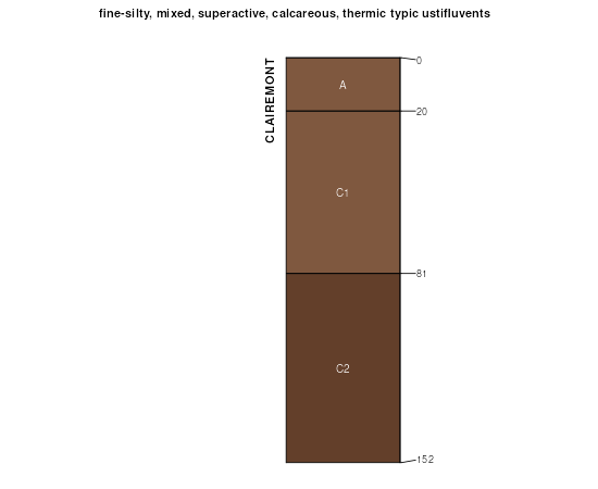
| Clairemont soils, channeled, frequently flooded | 5314 | 26747 | 1382468 | 2wrw3 | ks007 | 1973 | 1:24000 |
Clairemont silt loam, 0 to 1 percent slopes, occasionally flooded, cool | 5312 | 11601 | 1382467 | 2wrvy | ks007 | 1973 | 1:24000 |
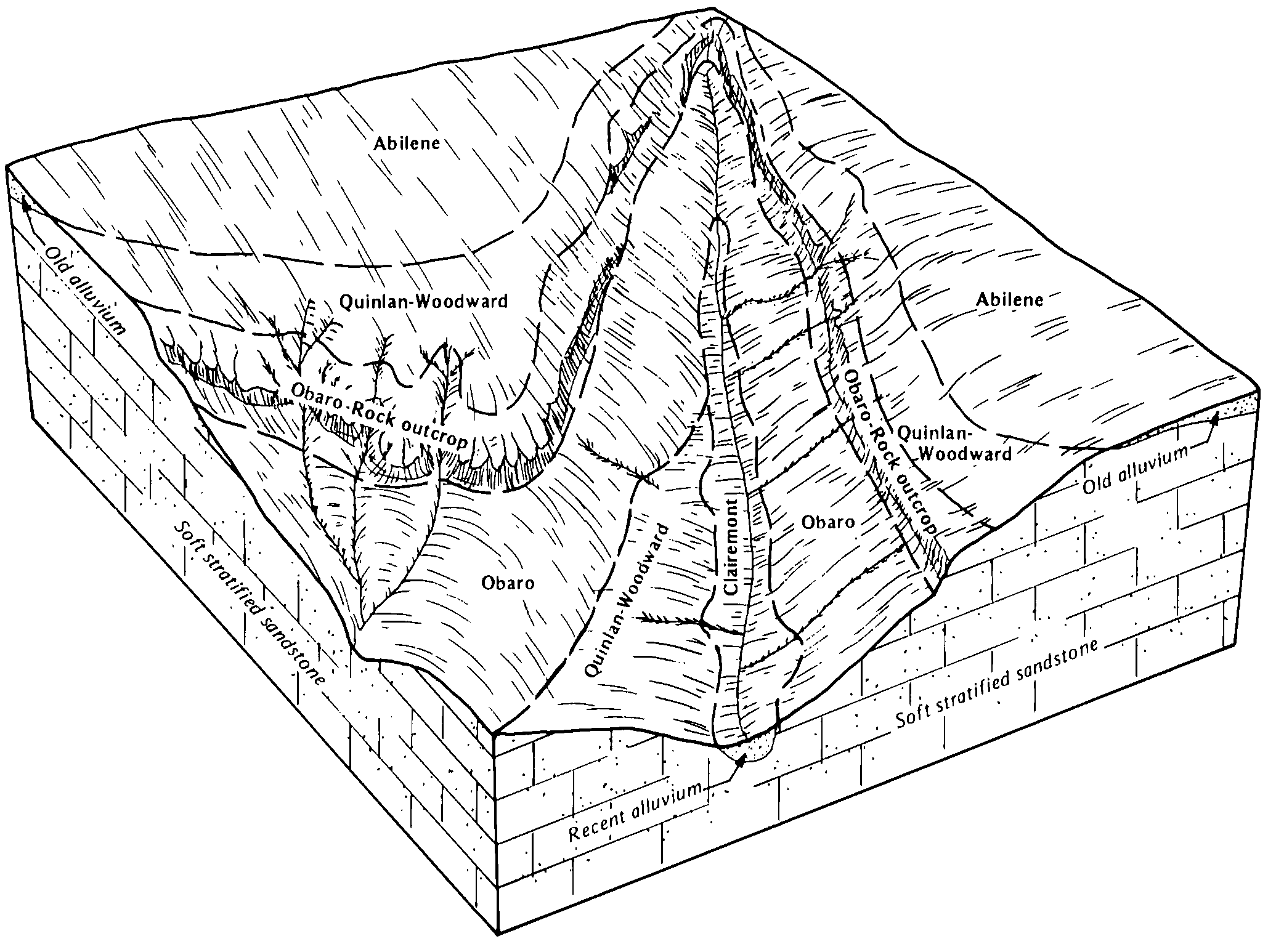
Quinlan-Clairemont complex, 0 to 50 percent slopes | 5451 | 10004 | 1382517 | 1hdmb | ks007 | 1973 | 1:24000 |
Clairemont soils, saline, channeled, frequently flooded | 5316 | 2344 | 1382469 | 2wrw4 | ks007 | 1973 | 1:24000 |
Clairemont loam, channeled, frequently flooded | 5310 | 1144 | 1382466 | 2wrw8 | ks007 | 1973 | 1:24000 |
Clairemont loam, channeled, frequently flooded | 5310 | 4216 | 1381249 | 2wrw8 | ks033 | 1987 | 1:24000 |
Clairemont silt loam, 0 to 1 percent slopes, occasionally flooded, cool | 5312 | 3459 | 1381250 | 2wrvy | ks033 | 1987 | 1:24000 |
Clairemont soils, saline, channeled, frequently flooded | 5316 | 639 | 1382675 | 2wrw4 | ks077 | 1965 | 1:24000 |
Clairemont soils, channeled, frequently flooded | 5314 | 10 | 1380497 | 2wrw3 | ks097 | 1983 | 1:24000 |
Clairemont silt loam, 0 to 1 percent slopes, occasionally flooded, cool | 8 | 9794 | 381708 | 2wrvy | ok009 | 1978 | 1:24000 |
Clairemont silt loam, 0 to 1 percent slopes, frequently flooded | 9 | 3434 | 381709 | 2wrw1 | ok009 | 1978 | 1:24000 |
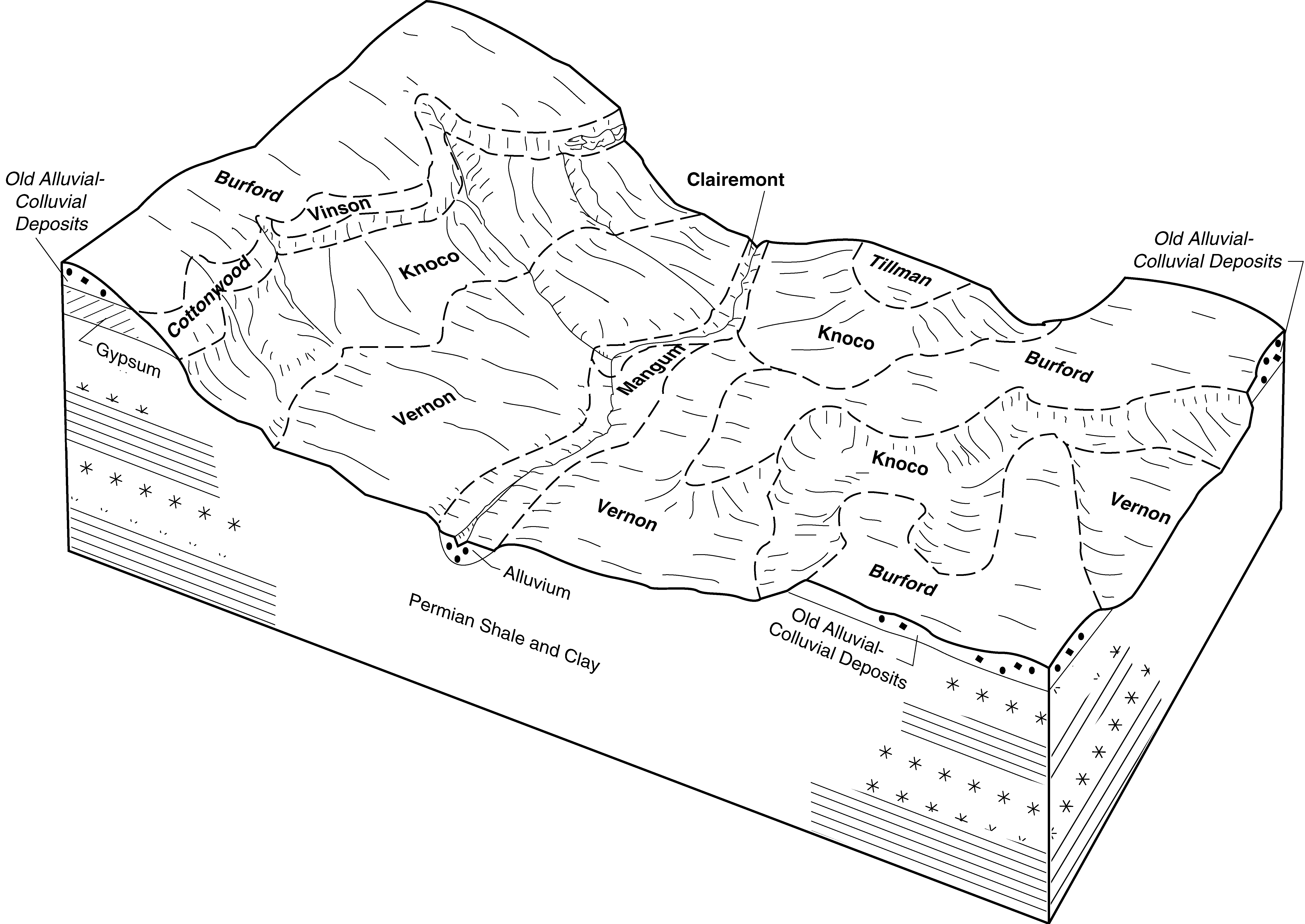
Vernon-Clairemont frequently flooded complex, 0 to 12 percent slopes | Bk | 16381 | 382165 | 2t025 | ok031 | 1965 | 1:24000 |
Clairemont silt loam, 0 to 1 percent slopes, occasionally flooded, cool | Cc | 27742 | 382312 | 2wrvy | ok039 | 1973 | 1:24000 |
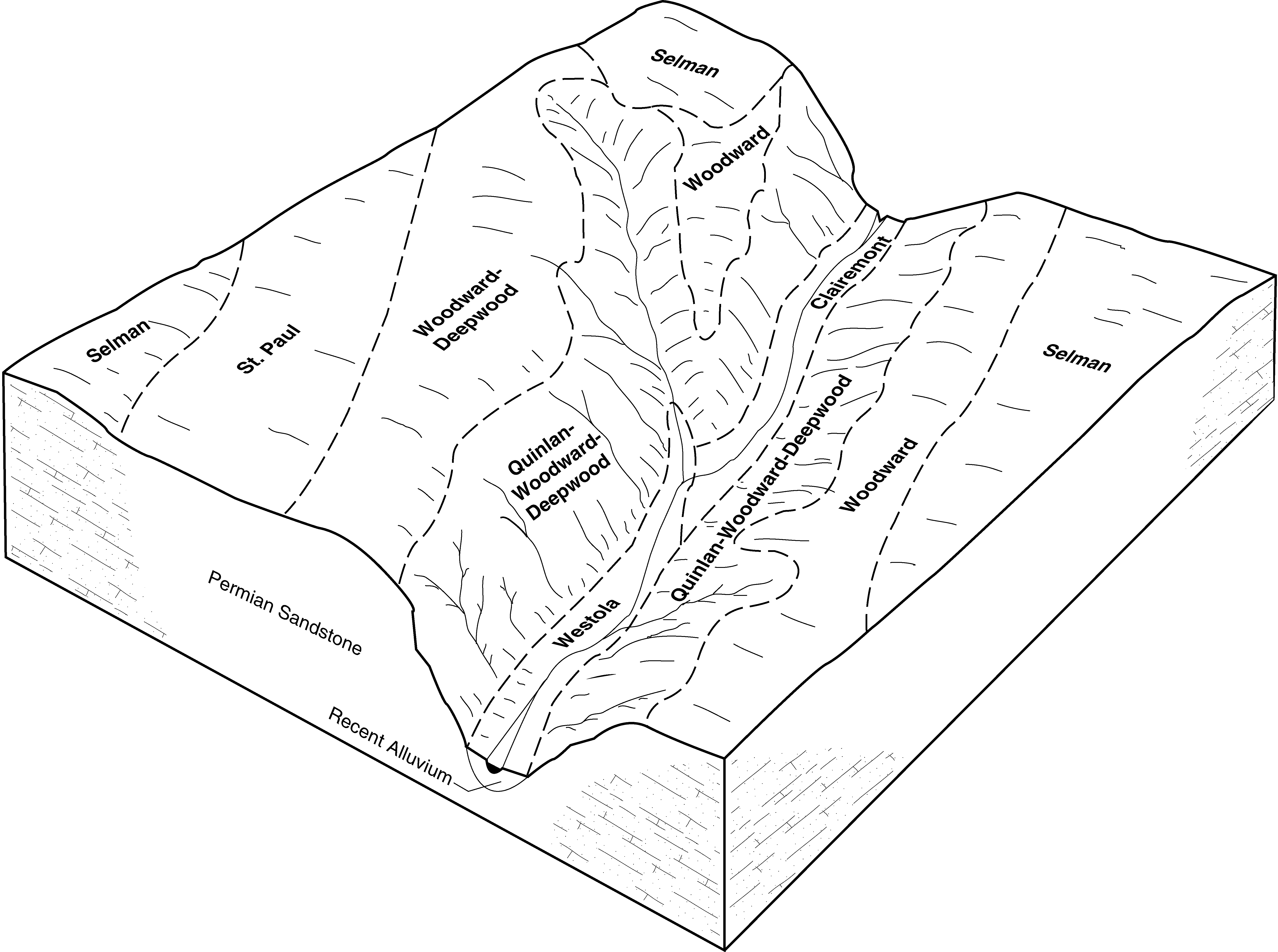
Woodward-Clairemont complex, 0 to 12 percent slopes | Wt | 7565 | 382349 | 2w5q2 | ok039 | 1973 | 1:24000 |
Clairemont silt loam, 0 to 1 percent slopes, frequently flooded | Cf | 1990 | 382314 | 2wrw1 | ok039 | 1973 | 1:24000 |
Clairemont silt loam, saline, 0 to 1 percent slopes, occasionally flooded | Ce | 1213 | 382313 | dttp | ok039 | 1973 | 1:24000 |
Clairemont silt loam, 0 to 1 percent slopes, occasionally flooded | 12 | 1763 | 975443 | 2s7n7 | ok057 | 1982 | 1:24000 |
Clairemont and Mangum soils, 0 to 1 percent slopes, frequently flooded | Cm | 25389 | 383442 | dw03 | ok075 | 1973 | 1:24000 |
Clairemont silt loam, 0 to 1 percent slopes, occasionally flooded, cool | No | 17754 | 384758 | 2wrvy | ok129 | 1961 | 1:24000 |
Clairemont silty clay loam, 0 to 1 percent slopes, channeled, frequently flooded | Ca | 19863 | 384938 | dxkc | ok141 | 1968 | 1:24000 |
Clairemont silty clay loam, saline, 0 to 1 percent slopes, frequently flooded | Ce | 6746 | 384939 | dxkd | ok141 | 1968 | 1:24000 |
Wheatwood-Clairemont complex, 0 to 1 percent slopes, occasionally flooded | At | 6386 | 384935 | dxk8 | ok141 | 1968 | 1:24000 |
Vernon-Clairemont frequently flooded complex, 0 to 12 percent slopes | Vn | 4159 | 384987 | 2t025 | ok141 | 1968 | 1:24000 |
Clairemont silt loam, 0 to 1 percent slopes, occasionally flooded, cool | 9 | 27309 | 385047 | 2wrvy | ok149 | 1976 | 1:24000 |
Woodward-Clairemont complex, 0 to 12 percent slopes | 53 | 9987 | 385040 | 2w5q2 | ok149 | 1976 | 1:24000 |
Clairemont silt loam, 0 to 1 percent slopes, frequently flooded | 10 | 5676 | 384993 | 2wrw1 | ok149 | 1976 | 1:24000 |
Clairemont silt loam, 0 to 1 percent slopes, occasionally flooded, cool | ClgA | 8167 | 385169 | 2wrvy | ok151 | 1995 | 1:24000 |
Clairemont silt loam, 0 to 1 percent slopes, frequently flooded | ClfA | 931 | 385168 | 2wrw1 | ok151 | 1995 | 1:24000 |
Clairemont silt loam, moist, 0 to 1 percent slopes, occasionally flooded | Cm | 38530 | 362702 | 2s7n9 | tx023 | 1971 | 1:24000 |
Clairemont silty clay loam, dry, 0 to 1 percent slopes, occasionally flooded | Cm | 989 | 363274 | 2y85b | tx045 | 1972 | 1:20000 |
Clairemont silt loam, 0 to 1 percent slopes, occasionally flooded | Ca | 3880 | 363967 | 2s7n7 | tx081 | 1968 | 1:24000 |
Clairemont silt loam, 0 to 1 percent slopes, rarely flooded | Cm | 1565 | 364008 | 2s7n8 | tx083 | 1968 | 1:24000 |
Clairemont silt loam, 0 to 1 percent slopes, occasionally flooded | Ca | 1777 | 365168 | 2s7n7 | tx129 | 1975 | 1:24000 |
Clairemont silt loam, 0 to 1 percent slopes, occasionally flooded | Ca | 2181 | 378327 | 2s7n7 | tx169 | 1965 | 1:24000 |
Clairemont silt loam, 0 to 1 percent slopes, occasionally flooded | Ca | 544 | 367909 | dbv1 | tx233 | 1972 | 1:24000 |
Clairemont silt loam, 0 to 1 percent slopes, occasionally flooded | Ca | 5452 | 368475 | 2s7n7 | tx263 | 1968 | 1:31680 |
Clairemont silt loam, 0 to 1 percent slopes, frequently flooded | 6 | 12987 | 368751 | 2wrw1 | tx275 | 1975 | 1:24000 |
Clairemont silt loam, moist, 0 to 1 percent slopes, occasionally flooded | 5 | 3755 | 368750 | 2s7n9 | tx275 | 1975 | 1:24000 |
Clairemont silt loam, 0 to 1 percent slopes, rarely flooded | Cn | 4308 | 369938 | 2s7n8 | tx307 | 1970 | 1:24000 |
Clairemont loam, saline, frequently flooded | Mm | 1835 | 370343 | dfck | tx317 | 1968 | 1:24000 |
Clairemont clay loam, slightly saline, rarely flooded | St | 249 | 370356 | dfcz | tx317 | 1968 | 1:24000 |
Clairemont silty clay loam, 0 to 2 percent slopes, occasionally flooded | Cc | 11371 | 3124137 | dg5b | tx359 | 1978 | 1:24000 |
Clairemont silty clay loam, 0 to 2 percent slopes, occasionally flooded | Cc | 11046 | 3124214 | dgd9 | tx375 | 1974 | 1:24000 |
Clairemont and Mangum soils, 0 to 1 percent slopes, frequently flooded | Cm | 6177 | 3124215 | dgdb | tx375 | 1974 | 1:24000 |
Clairemont silt loam, frequently flooded | Cm | 942 | 371941 | dh13 | tx411 | 1980 | 1:24000 |
Clairemont silty clay loam, moist, 0 to 1 percent slopes, occasionally flooded | Cm | 3199 | 372054 | 2y85c | tx417 | 1985 | 1:24000 |
Clairemont silty clay loam, 0 to 2 percent slopes, frequently flooded, channeled | Cn | 2898 | 372055 | 2y85d | tx417 | 1985 | 1:24000 |
Clairemont silty clay loam, 0 to 2 percent slopes, frequently flooded, channeled | Cn | 3191 | 372175 | 2y85d | tx429 | 1985 | 1:24000 |
Clairemont silty clay loam, moist, 0 to 1 percent slopes, occasionally flooded | Cm | 2310 | 372174 | 2y85c | tx429 | 1985 | 1:24000 |
Clairemont silt loam, 0 to 1 percent slopes, occasionally flooded | Ca | 3058 | 372263 | 2s7n7 | tx433 | 1970 | 1:24000 |
Clairemont silty clay loam, 0 to 1 percent slopes, occasionally flooded | Ca | 7856 | 391507 | 2y85g | tx441 | 1971 | 1:20000 |
Clairemont-Urban land complex, 0 to 1 percent slopes, occasionally flooded | Cn | 2976 | 391508 | 2y85h | tx441 | 1971 | 1:20000 |
Clairemont silt loam, moist, 0 to 2 percent slopes, occasionally flooded | Cm | 11827 | 372682 | 2z16c | tx447 | 1991 | 1:24000 |
Clairemont silt loam, 0 to 1 percent slopes, occasionally flooded, cool | Cm | 1614 | 373285 | 2wrvy | tx483 | 1970 | 1:24000 |
Clairemont silt loam, moist, 0 to 1 percent slopes, occasionally flooded | Ca | 14791 | 373338 | 2s7n9 | tx485 | 1972 | 1:20000 |
Clairemont-Urban land complex | Cb | 1145 | 373339 | djh6 | tx485 | 1972 | 1:20000 |
Clairemont soils, wet | Cc | 456 | 373340 | djh7 | tx485 | 1972 | 1:20000 |
Clairemont clay loam, 0 to 1 percent slopes, frequently flooded | Lo | 32730 | 373423 | 2z16d | tx487 | 1960 | 1:20000 |
Clairemont clay loam, 0 to 1 percent slopes, occasionally flooded | Nc | 15141 | 373436 | 2rhnm | tx487 | 1960 | 1:20000 |
Clairemont silt loam, moist, 0 to 1 percent slopes, occasionally flooded | No | 1312 | 373437 | 2s7n9 | tx487 | 1960 | 1:20000 |
Clairemont soils, 0 to 1 percent slopes, frequently flooded | 24 | 5264 | 390998 | f3vv | tx602 | 1975 | 1:24000 |