| Leaps family-Bonneville, very stony-Haydenfork family complex, 1 to 40 percent slopes, landslides | 420B | 12100 | 507543 | k14c | co650 | | 1:24000 |
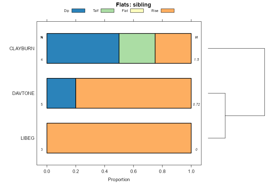
Clayburn, warm-Booneville-Needleton family complex, 25 to 65 percent slopes | 121 | 24164 | 509468 | k34g | co660 | 1994 | 1:24000 |
Booneville, warm-Doughspon complex, 5 to 15 percent slopes, very stony | 105 | 16045 | 509445 | k33q | co660 | 1994 | 1:24000 |
Booneville-Needleton family-Doughspon complex, 5 to 25 percent slopes, very stony | 106 | 15375 | 509446 | k33r | co660 | 1994 | 1:24000 |
Booneville-Clayburn association, 5 to 40 percent slopes | 107 | 4195 | 2453660 | 2nc7b | co664 | 1987 | 1:24000 |
Parkay-Dehana-Booneville association, 5 to 50 percent slopes | 1220 | 13427 | 3270929 | j9nb | id675 | 1992 | 1:24000 |
Southmount-Booneville complex, 5 to 40 percent slopes | 161 | 4371 | 486021 | j9r3 | id675 | 1992 | 1:24000 |
Booneville family-Enentah family-Zeebar complex, 20 to 60 percent slopes | 127AY | 6363 | 3239012 | 2ztdl | id703 | | 1:24000 |
Warshod family, extremely stony surface-Booneville-Camelback complex, 20 to 55 percent slopes | 86-CNF | 128 | 3173237 | 2rfzx | id711 | 1983 | 1:24000 |
Broad Canyon, very stony surface-Booneville-Moonlight complex, 35 to 65 percent slopes | 412 | 56 | 3173247 | 2pwvn | id711 | 1983 | 1:24000 |
Booneville-Davtone family-Dranburn complex, 25 to 60 percent slopes | 416 | 27 | 3173248 | 2rfzz | id711 | 1983 | 1:24000 |
Dranburn-Winnemucca-Booneville complex, 10 to 40 percent slopes, MLRA 47 | 1011w | 92 | 3173294 | 2wzzq | id712 | 2008 | 1:24000 |
Broad Canyon, very stony surface-Booneville-Moonlight complex, 35 to 65 percent slopes | 412 | 38 | 3173267 | 2pwvn | id712 | 2008 | 1:24000 |
Booneville-Dranyon-Zeebar family, very stony surface, complex, 15 to 40 percent slopes | 1058 | 21 | 3173297 | 2x006 | id712 | 2008 | 1:24000 |
Spearhead family-Spearhead family, warm-Booneville complex, 30 to 60 percent slopes | 1027 | 11554 | 2917034 | 2w9rs | id713 | | 1:24000 |
Broad Canyon, very stony surface-Booneville-Moonlight complex, 35 to 65 percent slopes | 412 | 7653 | 2497415 | 2pwvn | id713 | | 1:24000 |
Booneville-Davtone family-Dranburn complex, 25 to 60 percent slopes | 416 | 4906 | 2619867 | 2rfzz | id713 | | 1:24000 |
Booneville-Ezbin-Davtone family, complex, 20 to 50 percent slopes | 1086a | 4134 | 2980859 | 2x00p | id713 | | 1:24000 |
Booneville-Groomer family, complex, 20 to 50 percent slopes | 843 | 4105 | 2733453 | 2slrq | id713 | | 1:24000 |
Dranburn-Winnemucca-Booneville complex, 10 to 40 percent slopes, MLRA 47 | 1011w | 3989 | 2980830 | 2wzzq | id713 | | 1:24000 |
Booneville-Stringam complex, 10 to 35 percent slopes | 891 | 3567 | 2984163 | 2x03h | id713 | | 1:24000 |
Booneville-Dranyon-Zeebar family, very stony surface, complex, 15 to 40 percent slopes | 1058 | 2820 | 2980844 | 2x006 | id713 | | 1:24000 |
Trapper-Booneville, very bouldery surface, families, complex, 6 to 20 percent slopes | 1070 | 2542 | 2980854 | 2x00j | id713 | | 1:24000 |
Broad Canyon-Dranburn-Booneville, stony surface, complex, 20 to 60 percent slopes | 975 | 2388 | 2968254 | 2wxbx | id713 | | 1:24000 |
Booneville loam, 15 to 40 percent slopes | 926 | 2299 | 2733510 | 2slt6 | id713 | | 1:24000 |
Daisypeak-Boonville-Cavemountain complex, 25 to 65 percent slopes | 983 | 2190 | 2963888 | 2wv3h | id713 | | 1:24000 |
Warshod family, extremely stony surface-Booneville-Camelback complex, 20 to 55 percent slopes | 86 | 1856 | 2619865 | 2rfzx | id713 | | 1:24000 |
Booneville-Farlow family, very stony surface-Dranyon complex, 25 to 50 percent slopes | 1058a | 1646 | 2980845 | 2x007 | id713 | | 1:24000 |
Sedgway family-Booneville complex, 15 to 35 percent slopes | 1020 | 1629 | 2899446 | 2w1g2 | id713 | | 1:24000 |
Booneville-Sponsor family, complex, 35 to 75 percent slopes | 892 | 1314 | 2984165 | 2x03k | id713 | | 1:24000 |
Yeates Hollow family, extremely stony surface-Manila family, very stony surface, perched water table-Booneville complex, 5 to 35 percent slopes | 1088 | 948 | 2980916 | 2x029 | id713 | | 1:24000 |
Dranburn-Winnemucca-Booneville, complex, 15 to 35 percent slopes, MLRA 43B | 861 | 866 | 2984242 | 2x03n | id713 | | 1:24000 |
Dailybasin family-Geemore family-Booneville complex, 10 to 55 percent slopes | 973 | 749 | 2968252 | 2wxbv | id713 | | 1:24000 |
Dranyon-Booneville-Hagenbarth complex, 5 to 30 percent slopes | 7005 | 169 | 2981067 | 2xxdj | id713 | | 1:24000 |
Booneville-Dranyon-Ireland complex, 20 to 55 percent slopes | 7010 | 31 | 2980919 | 2xxdk | id713 | | 1:24000 |
Booneville-Davtone family-Dranburn complex, 25 to 60 percent slopes | 416 | 153 | 3173343 | 2rfzz | id714 | 1997 | 1:24000 |
Broad Canyon, very stony surface-Booneville-Moonlight complex, 35 to 65 percent slopes | 412 | 57 | 3173339 | 2pwvn | id714 | 1997 | 1:24000 |
Yeates Hollow family, extremely stony surface-Manila family, very stony surface, perched water table-Booneville complex, 5 to 35 percent slopes | 1088 | 8 | 3173403 | 2x029 | id714 | 1997 | 1:24000 |
Booneville-Ezbin-Davtone family, complex, 20 to 50 percent slopes | 1086a | 5 | 3173352 | 2x00p | id714 | 1997 | 1:24000 |
Dranburn-Winnemucca-Booneville complex, 10 to 40 percent slopes, MLRA 47 | 1011w | 0 | 3173350 | 2wzzq | id714 | 1997 | 1:24000 |
Booneville-Davtone family-Dranburn complex, 25 to 60 percent slopes | 416 | 0 | 3173371 | 2rfzz | id715 | 1994 | 1:24000 |
Booneville-Dranyon-Ireland complex, 20 to 55 percent slopes | 7010 | 3821 | 3074036 | 2xxdk | id716 | | 1:24000 |
Mayhill-Booneville-Dateman complex, 15 to 60 percent slopes | 7030 | 2392 | 2989729 | 2x3mr | id716 | | 1:24000 |
Dranyon-Booneville-Hagenbarth complex, 5 to 30 percent slopes | 7005 | 2072 | 3074035 | 2xxdj | id716 | | 1:24000 |
Booneville-Stringam complex, 10 to 35 percent slopes | 891 | 1220 | 3163462 | 2x03h | id716 | | 1:24000 |
Booneville loam, 15 to 40 percent slopes | 926 | 105 | 3163473 | 2slt6 | id716 | | 1:24000 |
Spearhead family-Spearhead family, warm-Booneville complex, 30 to 60 percent slopes | 1027 | 74 | 2984400 | 2w9rs | id716 | | 1:24000 |
Booneville-Sponsor family, complex, 35 to 75 percent slopes | 892 | 21 | 3163463 | 2x03k | id716 | | 1:24000 |
Booneville family-Enentah family-Zeebar complex, 20 to 60 percent slopes | 127AY | 321 | 3320466 | 2ztdl | id720 | | 1:24000 |
Booneville-Groomer family, complex, 20 to 50 percent slopes | 843 | 185 | 2858649 | 2slrq | id758 | 1998 | 1:24000 |
Booneville-Hagenbarth, moist complex, 10 to 50 percent slopes | 9 | 1408 | 83808 | 2t6h | id762 | 1988 | 1:24000 |
Booneville-Crystalbutte complex, 4 to 20 percent slopes | 8 | 373 | 83797 | 2t64 | id762 | 1988 | 1:24000 |
Mayhill-Booneville-Dateman complex, 15 to 60 percent slopes | 7030 | 95 | 3238996 | 2x3mr | id770 | 1968 | 1:24000 |
Booneville, very stony-Drywolf, very rubbly families-Rubble land complex, 25 to 60 percent slopes | 1467F | 49 | 3039672 | 2qbzk | mt602 | 1963 | 1:20000 |
Elkpeak, stony-Booneville-Adel complex, 4 to 25 percent slopes | 920E | 439 | 2598015 | 2ppb5 | mt605 | 2007 | 1:24000 |
Lonniebee, bouldery-Wesdy, very stony-Booneville complex, 8 to 35 percent slopes, landslides | 746E | 4426 | 2512550 | 2pphy | mt612 | 2011 | 1:24000 |
Elkpeak, stony-Booneville-Adel complex, 4 to 25 percent slopes | 920E | 1317 | 2518722 | 2ppb5 | mt614 | 2012 | 1:24000 |
Booneville, family-Bigcoulee-Slidemountain, stony family, complex, 20 to 60 percent slopes | 1290F | 275 | 3044842 | 2v1mz | mt615 | 1992 | 1:24000 |
Booneville-Lingshire-Adel complex, 15 to 60 percent slopes | 335F | 4106 | 2486253 | 2pg4q | mt632 | | 1:24000 |
Booneville, very stony-Drywolf, very rubbly families-Rubble land complex, 25 to 60 percent slopes | 1467F | 1591 | 2632240 | 2qbzk | mt632 | | 1:24000 |
Elkpeak, stony-Booneville families-Rubble land complex, 2 to 25 percent slopes | 1467E | 1529 | 2632239 | 2qbzj | mt632 | | 1:24000 |
Booneville, family-Bigcoulee-Slidemountain, stony family, complex, 20 to 60 percent slopes | 1290F | 1472 | 2833638 | 2v1mz | mt632 | | 1:24000 |
Booneville-Lingshire-Adel complex, 15 to 60 percent slopes | 335F | 2979 | 2398256 | 2lhl3 | mt637 | 2014 | 1:24000 |
Spanpeak, stony-Booneville-Surdal, stony complex, 35 to 70 percent slopes | 8605F | 3662 | 156769 | 5842 | mt669 | | 1:24000 |
Booneville-Tiban, extremely bouldery-Rocko, extremely stony, complex, 15 to 60 percent slopes | 5618F | 3022 | 156459 | 57t2 | mt669 | | 1:24000 |
Boneville, stony-Woodhurst-Arrowpeak, very stony, complex, 25 to 60 percent slopes | 5658F | 2837 | 741528 | swm8 | mt669 | | 1:24000 |
Odark-Booneville loams, 15 to 45 percent slopes | 5647F | 2663 | 711079 | rvy1 | mt669 | | 1:24000 |
Wineglass-Booneville, complex, extremely bouldery, 15 to 60 percent slopes | 5621F | 2278 | 699328 | rgpz | mt669 | | 1:24000 |
Booneville-Odark complex, 15 to 60 percent slopes | 3619F | 1917 | 696034 | rc8q | mt669 | | 1:24000 |
Bavdark-Booneville, stony-Libeg, very stony, complex, 8 to 35 percent slopes | 5505E | 1434 | 156729 | 582s | mt669 | | 1:24000 |
Booneville very stony -Adel -Copenhaver stony complex ,moist, 15 to 60 percent slopes | 3616F | 1058 | 697430 | rdqr | mt669 | | 1:24000 |
Boonville, extremely bouldery-Adel-Spanpeak, bouldery complex, 8 to 45 percent slopes | 3502F | 854 | 156637 | 57zt | mt669 | | 1:24000 |
Booneville stony-Tepete-Foolhen complex, 8 to 25 percent slopes | 3536E | 391 | 697312 | rdly | mt669 | | 1:24000 |
Booneville family, fire, 15 to 40 percent slopes | 255 | 1531 | 2934303 | 2wgkv | nm678 | | 1:24000 |
Booneville-Stringam complex, 10 to 35 percent slopes | 891 | 110 | 3083477 | 2x03h | wy623 | 1971 | 1:20000 |
Sedimentary Till-Mantled Sideslopes (West), Subalpine Fir Complex | 3648 | 7776 | 151873 | 5314 | wy662 | 1998 | 1:24000 |
Booneville-Mayflower-Wetopa, moderately deep, families, complex, 10 to 40 percent slopes | 224 | 6139 | 151965 | 5343 | wy663 | 2012 | 1:24000 |