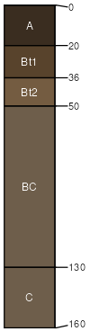
Sawbuck-Catgulch, stony, complex, 8 to 45 percent slopes
Sawbuck
(65%)
Upland Sagebrush Shrubland Group
Typic Argiustolls
Well drained
Hydric: No
PAWS: 11 cm
escarpments
hillsides
mountain slopes
alluvial fans
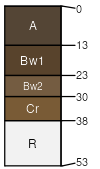
Catgulch
(20%)
Shallow Grassland Group
Lithic Haplustolls
Well drained
Hydric: No
PAWS: 2 cm
escarpments
ridges
hillsides
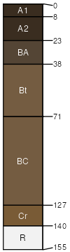
Crackerville
(6%)
Upland Shrubland Group
Typic Argiustolls
Well drained
Hydric: No
PAWS: 6 cm
ridges
hillsides
escarpments
Sawicki
(4%)
Upland Shrubland Group
Typic Argiustolls
Well drained
Hydric: No
PAWS: 14 cm
alluvial fans
mountain slopes
escarpments
hillsides
Bielenberg
(3%)
Upland Sagebrush Shrubland Group
Typic Argiustolls
Well drained
Hydric: No
PAWS: 16 cm
ridges
hillsides
Rock outcrop
(2%)
Hydric: No
PAWS: NA
SSA
Scale
Published
Export
mt627
1:24,000
1998
2025-08-31