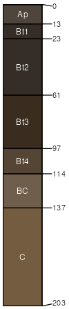
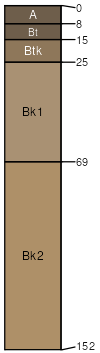
Kimst (45%)
Loamy Plains
Aridic Ustorthents
Well drained
Hydric: No
PAWS: 27 cm |
|
|
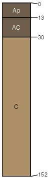
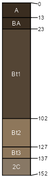
Richfield (30%)
Loamy Plains
Aridic Argiustolls
Well drained
Hydric: No
PAWS: 28 cm |
|
|
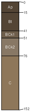
Rago (10%)
Overflow
Pachic Argiustolls
Well drained
Hydric: No
PAWS: 27 cm |
|
|
Stoneham (5%)
Loamy Plains
Aridic Haplustalfs
Well drained
Hydric: No
PAWS: 27 cm |
|
|
Bethune (5%)
Loamy Plains
Aridic Argiustolls
Well drained
Hydric: No
PAWS: 11 cm |

|
|
Rock outcrop (2%)
Hydric: No
PAWS: 0 cm |

|
|
Pleasant (2%)
Closed Depression
Torrertic Argiustolls
Moderately well drained
Hydric: No
PAWS: 27 cm |
|
|
|