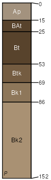
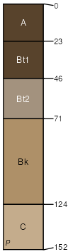
Ascalon-Platner association, 0 to 5 percent slopes
Ascalon
(60%)
Sandy Plains
Aridic Argiustolls
Well drained
Hydric: No
PAWS: 22 cm
interfluves / Summit
interfluves / Backslope
Platner
(40%)
Loamy Plains
Aridic Paleustolls
Well drained
Hydric: No
PAWS: 25 cm
interfluves / Summit
SSA
Scale
Published
Export
co001
1:20,000
1968
2025-08-29