Cedargap, frequently flooded-Pinerun, occasionally flooded complex, 1 to 3 percent slopes
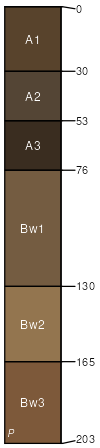
Cedargap
(65%)
Gravelly/Loamy Upland Drainageway Forest
Cumulic Hapludolls
Well drained
Hydric: No
PAWS: 9 cm
drainageways
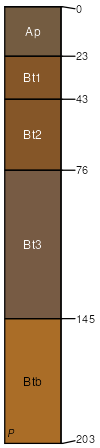
Pinerun
(25%)
Gravelly/Loamy Upland Drainageway Forest
Typic Hapludalfs
Well drained
Hydric: No
PAWS: 12 cm
drainageways
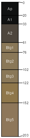
Farewell
(10%)
Wet Upland Drainageway Forest
Typic Argiaquolls
Somewhat poorly drained
Hydric: Yes
PAWS: 28 cm
flood plains
SSA
Scale
Published
Export
mo119
1:24,000
2004
2025-09-02