Grangemont-Riswold complex, 10 to 35 percent slopes
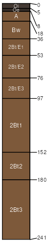
Grangemont
(45%)
Ashy Hills and Mountains 30-45 PZ Frigid Western Bitterroot Foothills
Andic Glossudalfs
Well drained
Hydric: No
PAWS: 48 cm
mountain slopes
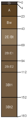
Riswold
(35%)
Ashy Basalt Hills and Canyons 30-45 PZ Frigid Eastern Columbia Plateau Embayments
Andic Hapludalfs
Well drained
Hydric: No
PAWS: 29 cm
mountain slopes
SSA
Scale
Published
Export
id612
1:24,000
2003
2025-08-27