Lewhand-Burntcreek complex, 0 to 2 percent slopes
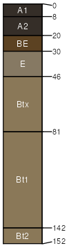
Lewhand
(65%)
Loamy High Water Table Floodplains 19-24 PZ Frigid Western Bitterroot Foothills
Vitrandic Fragiudalfs
Poorly drained
Hydric: Yes
PAWS: 21 cm
flood plains
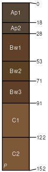
Burntcreek
(20%)
Vitrandic Hills and Mountains 30-45 PZ Frigid Western Bitterroot Foothills
Vitrandic Hapludolls
Somewhat poorly drained
Hydric: No
PAWS: 21 cm
flood plains
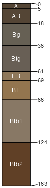
Teneb
(2%)
MEADOW
Aquandic Epiaqualfs
Poorly drained
Hydric: Yes
PAWS: 32 cm
drainageways
SSA
Scale
Published
Export
id612
1:24,000
2003
2025-08-27