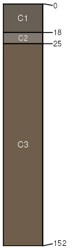
Carrolls sand, flooded, 0 to 2 percent slopes
Carrolls
(85%)
Portland Basin Riparian Forest
Typic Psammaquents
Somewhat poorly drained
Hydric: Yes
PAWS: 14 cm
flood plains
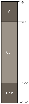
Mountsolo
(10%)
Somewhat poorly drained
Hydric: No
PAWS: NA
terraces
Cowlitz
(5%)
Somewhat excessively drained
Hydric: No
PAWS: NA
SSA
Scale
Published
Export
wa015
1:24,000
1994
2025-08-28